

Places
2 places found.
Those places high-lighted have photos. All locations may have maps, books and memories.
Photos
11 photos found. Showing results 1 to 11.


Maps
10 maps found.


Books
Sorry, no books were found that related to your search.
Memories
102 memories found. Showing results 1 to 10.
Nostalgia
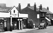
The garage, owned if memory serves by the Harrison family, was always a magnet for a small boy, because in addition to selling petrol and repairing cars it also sold Meccano and Dinky toys. I also remember my grandmother buying me the Sunny ...Read more
A memory of Langwith in 1948 by
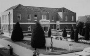
Happy Hours Of Reading But Also Destruction.
So many hours of reading here in this library. The children's section was in the main door and to the right served by the 2 windows shown on the ground floor. I recall taking out every Arthur Ransome title ...Read more
A memory of Wallington by
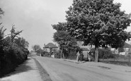
Hornchurch, Wingletye Lane Circa 1950
For the first part of my life from 1947 I lived in Glanville Drive which ran parallel to Wingletye Lane about 100 yards to the West of where the photograph was taken. The railings to the right of the photograph ...Read more
A memory of Hornchurch by
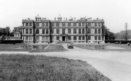
Sixties Longleat
Many fond memories of Longleat over the last 46 years: the freedom we all enjoyed as villagers to roam across the estate - the sixth Marquess was always very generous in this respect. The remains of the American hospital were still ...Read more
A memory of Longleat in 1966 by
Memories Of Childhood
I was born 1943 in Purley Cottage Hospital, lived at 2 The Mount, christened at St Peters and taught at Woodmansterne Primary for a while. Walked to school via Hatch Lane and Rectory Lane and where they joined is, I think, ...Read more
A memory of Woodmansterne by
Grand Living At Moresdale Hall, Lambrigg
We came to a deserted Moresdale Hall in the 1980s and spent several years refurbishing it. Because it had 2 front doors and 2 staircases we were able to divide it and share it with my brother's family. It ...Read more
A memory of Moresdale Hall
Plashet Grove
Before & during the Second World War my uncle was an electrical engineer & had a shop in Plashet Grove opposite Washington Road. Unfortunately I wasn't born until 1946 & so I have no knowledge of the shop except some photos ...Read more
A memory of Upton Park by
Harworth 'old' Village
The large Horse Chestnut tree to the right was very popular when conkers were in season with boys searching the ground and throwing whatever came to hand at the tree to try and dislodge the nuts that were temptingly out of ...Read more
A memory of Harworth in 1964 by
Where I Was Born
My Beginning, at Sole Street near Cobham Kent. (9th March 1946 - 2nd January 1951) I was born on Saturday March 9th 1946 at 3.29pm at Temperley, The Street, Sole Street, Kent. I was delivered at home by the ...Read more
A memory of Sole Street in 1946
Dunsmore People And Happenings Remembered
PREFACE TO THE SECOND EDITION In 1995, when the first edition of this history was published, it seemed incredibly optimistic to have had three hundred copies printed for a market which was ...Read more
A memory of Dunsmore by
Captions
233 captions found. Showing results 1 to 24.

Burford sits right on the county boundary with Herefordshire - the boundary is defined by the River Teme at this point.

Parish boundaries cross and re-cross with those of Myerscough and Barton - one boundary cuts through the bowling green of the Roebuck Inn, as it was known in earlier days.

Along the Sywell Road, from the 1950s on, closes of expensive houses were built within the park boundary, retaining many of the specimen trees.

The parish boundary runs along the river, and was formerly the county boundary too, for Welford was in Gloucestershire until 1931.

It served the Sutton New Town development to the east of Manor Park up to the Carshalton parish boundary.

At one time the county boundary, now defined by the River Tamar two miles to the north, ran between the two villages, and the old boundary stone can still be seen beside the road.

Local government boundary changes brought Leighton Buzzard and Linslade together into the town of Leighton- Linslade and placed them both in Bedfordshire.

The parish boundaries meet here with those of Myerscough and Barton; indeed, one boundary cuts through the Roebuck's bowling green.

The line of the paling on the left marked the boundary of the old Borough of Petersfield.

Hocombe Road is the northern boundary of Hiltingbury, and indeed of the borough.

In 1951 the Borough of Swindon purchased Penhill Farm, which lay in the parish of Stratton St Margaret, just outside the borough boundary north of the town, for housing.

The medieval bridge, built about 1340, crosses the Wensum into Bishopgate, which continues around the Cathedral boundary until it becomes Palace Street.
The medieval bridge, built about 1340, crosses the Wensum into Bishopgate, which continues around the Cathedral boundary until it becomes Palace Street.

With rose beds, trees and the river Wye on its boundary, it is small wonder that this is such a popular place.

At one time straddling the county boundary with Huntingdonshire, Everton was listed as Euretone in the Domesday Book.

Close to the county boundary, Roydon retains a timeless air.

Over the Town Bridge, which forms the old county boundary, the power station has been replaced with a shopping centre.

Tetbury lies near the boundary of Gloucestershire and Wiltshire on the long stretch of high road between Stroud and Malmesbury.

Not far beyond the town the journey through Dorset ends as the boundary of Hampshire is reached.
As to the rest of the photograph, the cottages are now one dwelling but even the boundary walls have changed little in over a century.

When Holy Trinity became an ecclesiastical parish in its own right in 1841 it included the West Park area, though this was taken away when the boundaries were adjusted in 1908.

The county boundary between Cambridgeshire and Norfolk actually runs along the middle of the river at this point, so the church is in Norfolk, while the pub is in Cambridgeshire!

Only a fragment of the original boundary wall remains in Judges Walk.

The Waveney forms the boundary between Suffolk and Norfolk, where the boys are fishing.
Places (2)
Photos (11)
Memories (102)
Books (0)
Maps (10)

