Places
Sorry, no places were found that related to your search.
Photos
Sorry, no photos were found that related to your search.
Maps
1,353 maps found.


Books
3 books found. Showing results 937 to 3.
Memories
2,048 memories found. Showing results 391 to 400.
Inholmes
My aunt and uncle became the caretakers at Inholmes after it was converted to offices. I remember the magnificent staircase which had a huge eagle as a newel post. The range in the kitchen was the biggest I have ever seen, and the ...Read more
A memory of Burgess Hill in 1952
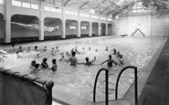
Seaton Carew Baths 1951
My memory of the Baths was getting up at 6.30am to get there for the First Session at 7am. I would swim until 8am then either ride on my bike or walk along the Seafront and Mainsforth Terrace, past the Coal Staithes to ...Read more
A memory of Seaton Carew in 1951 by
Born On Sutton Flats
I was born on Sutton Flats (now demolished) Pendleton in 1941. My first vague memory was sitting under a table with a blanket draped over it and a lit candle (must have been an air-raid on at the time). My first real memory ...Read more
A memory of Salford by
What A Scare
It was a cold and wet evening when I had arrived in Peterborough, and having little money on me certainly not enough to pay for some hotel. I had been thumbing lifts from various towns, but as it was teeming it down with rain, I did not ...Read more
A memory of Eye in 1971 by
Hemsby In The 70s And 80s
We started holidaying in Hemsby in the late 1970s. My parents loved it as we'd always had caravan holidays previously but now we had a chalet!! They always stayed at Belle Aire site. Hemsby was pretty spartan in those ...Read more
A memory of Hemsby by
My Mother Was Evacuated To Buckinghamshire Twice!
Britain declared war on Germany in September 1939, and this country's involvement in the Second World War began. German air-raids and gas attacks were expected imminently, and many ...Read more
A memory of Princes Risborough in 1940 by
The Cross
Most of the names state the obvious. This is an important crossroad. Turn right to go to Mill Green along Mill Lane. Turn left to go to Vye's Stores (pre-1960) and then to the Church in Church Lane or down Brook Lane, where we assume the ...Read more
A memory of Eastry by
Illy Owley
My name is Andrew Tate, I was born in Thornlaw South at my grandparents house in 1944. I was a twin and my brother was called Alexander [Aleck]. I have quite a few memories of Thornley, I remember watching a cricket match in the Illey ...Read more
A memory of Thornley in 1949 by
The Old Days
Hi, I am Linda Atkinson, nee Halford, I was brought up on the Gypsy Lane estate, attending Woodhouse Junior school and remember the carnivals/parades held on the village green. My best friends were Nancy and Maria Churms, and ...Read more
A memory of Normanton by
Longley Road, Tooting 1950
Hi. I lived in Longley Road, Tooting opposite the bus station at the Tooting Junction end of Longley Road from 1950. We lived in a flat above Cussons grocery store until the site was bought and demolished by the council, for ...Read more
A memory of Tooting
Captions
1,059 captions found. Showing results 937 to 960.

Looking along the High Street past the beleaguered Burton Memorial, one would see little change today in the buildingscape.

This is the main shopping area of the town; the architecture matches the period of rapid development after the railway arrived.

On the right of the photograph is the 15th-century God's House Tower, formerly the south-east gate of the old town and one of the earliest artillery fortifications in Europe.

Bath Street curves away northwards from the Square and its junction with the High Street.

A water mill has stood here since Norman times, but this red brick corn mill dates from the early 1800s.

A scattered village on a hilltop in the centre of Sussex. Friendly societies began here at the Five Bells Inn in 1782.

Tenby was described thus in a Victorian guidebook of 1895: 'Tenby stands on a tongue of limestone rock, ending in a green promontory, which is crowned by the ruins of the old castle, and is now pleasantly
Tenby was described thus in a Victorian guidebook of 1895: 'Tenby stands on a tongue of limestone rock, ending in a green promontory, which is crowned by the ruins of the old castle, and is now pleasantly

The Marine Lake covered what had been fifty acres of wet sand, which was one of the favourite haunts of sand yacht enthusiasts.

Aberdour in the Kingdom of Fife, lies between Burntisland and Dalgety Bay, just across the Firth of Forth from Edinburgh.

The size of the Looe Hotel in Fore Street reflects the growing tourist industry, which was stimulated at Looe by a railway branch that had been connected to the main line system just seven years before

The camera looks north across the Golders Green Road/North End Road crossing.

This was originally a terrace of very large houses built by Edward Welby Pugin. They failed to sell, and the terrace was converted to a hotel in 1869. In 1873, Pugin was bankrupted.

This pond with its island is a most attractive feature in the outer part of the town. While it is somewhat municipalised nowadays, it is very ancient.

The church of St Margaret was rebuilt in 1852 and has a tower dating from 1507, which is just visible through the trees. The Pigeon House is a medieval yeoman's house.

As well as excursions up the Fal, ferries operated to Flushing and St Mawes Castle. Larger excursion steamers were employed on runs to the Lizard and Penzance.
The Marine Lake covered what had been fifty acres of wet sand, which was one of the favourite haunts of sand yacht enthusiasts.

This old coaching inn is one of many in Daventry which stood on the London to Holyhead turnpike.

Shaw developed as part of Crompton and by the early 1900s it had 29 spinning mills.

This village stands on the south-west edge of the Isle of Ely. In the 17th century the fens around Sutton were drained by farmers with the help of wind pumps.

Seaside bustle on the promenade, built as the old Upper Walk between the town and the Cobb Harbour in 1817; it is now known as Marine Parade.

In thirty years, this scene would be reinterpreted to become the Broadway. Gone would be the village pump, the pond and the water splash.

This village of great beauty is said to be the most photographed in Hertfordshire.

Now around to the south-west side of Glastonbury, where Wearyall Hill lies between the town and the river Brue. The name is a corruption of 'Wirral Hill', a deer-park established by the Abbots.
Places (0)
Photos (0)
Memories (2048)
Books (3)
Maps (1353)

