Places
17 places found.
Those places high-lighted have photos. All locations may have maps, books and memories.
- Bridge End, Oxfordshire
- Bridge End, Lincolnshire
- Bridge End, Essex
- Bridge End, Bedfordshire
- Bridge End, Clwyd
- Bridge End, Warwickshire
- Bridge End, Surrey
- Bridge End, Durham (near Frosterley)
- Bridge End, Northumberland (near Hexham)
- Bridge End, Hereford & Worcester (near Tirley)
- Bridge End, Hereford & Worcester (near Bosbury)
- Bridge End, Shetland Islands
- Bridge End, Cumbria (near Carlisle)
- Bridge End, Northumberland (near Hexham)
- Bridge End, Devon (near Kingsbridge)
- Bridge End, Devon (near Sidmouth)
- West End, Yorkshire (near Pateley Bridge)
Photos
40 photos found. Showing results 241 to 40.
Maps
520 maps found.


Books
2 books found. Showing results 289 to 2.
Memories
1,924 memories found. Showing results 121 to 130.
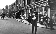
Chelmsford, Shops In The High Streeet, 1919.
This view is taken from outside the island where the current Lloyds Bank stands, and shows the view down the High Street. In the background can be seen the spire, which was the Wesleyan Church, and ...Read more
A memory of Chelmsford by
Short Memories Of Burnt Oak
Writing this is difficult. I lived in Burnt Oak as far as I know from 1949 to 1953. I recall living in a top floor flat in 100 Littlefield Road. I attended a school off Gervas Road but cannot remember the name. I do ...Read more
A memory of Edgware in 1951
Motorboats
My parents had a caravan in Heachem and as children we used to visit Hunstanton all the time. My fondest memory was the motorboats. I used to feel very grown up driving the boat on my own under the little bridge. It probably wasn't as big as I remember but was the highlight of my holidays.
A memory of Hunstanton in 1880
The Railway Inn
My Gran - Katherine Thomas - ran the Railway Inn (the Tap) for many years. My grandfather Thomas died shortly after I was born. My mother Hilda Jeffery (nee Thomas), my father William Jeffery and myself lived there. My mum died ...Read more
A memory of Llansamlet by
Fishing 1965 On The North Forty Drain
We all went to stop on a farm near Landgrick Road in the year 1965 for one week of fishing, we all came from Pinxton and South Normanton, Nottinghamshire and Derbyshire, catching loads of fish, bream, ...Read more
A memory of Brothertoft
Carrog Memory, As A Ww2 Evacuee.
I first visited Carrog in 1939 as an evacuee, at the start of World War 2. I was accompanied by my two sisters, having travelled by train from Birkenhead on the Wirral. All the evacuees were escorted to the Church ...Read more
A memory of Carrog in 1940 by
The Bathing Hole
The stream in front of the war memorial ran down to the Browney river a few hundred yards below the Dean, where half of the Witton school kids learned to swim in deep pools created by dams made by Harry Bell and Davy ...Read more
A memory of Witton Gilbert in 1954 by
Childhood Memories
My granny used to live in Hole House, Lane Little Leigh, her name was Ellen Frances Hough, and I remember she used to live next door to Mr and Mrs Astbury. My dad used to take me there on a Friday night and pick me up on a ...Read more
A memory of Little Leigh in 1961 by
Memories Of Leadgate And Iveston 1938 1943
I came to live at Leadgate when I was 12 years old and attended Leadgate Council School which was a large red brick building for infants and juniors, boys and girls. I was at the school for only 2 years, ...Read more
A memory of Leadgate in 1930 by
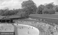
Open Air Swimming Pool Colchester
Many a happy day was spent at the open air swimming pool in the late 1950s - early 1960s. The changing rooms, under the road bridge, were not nice and always covered in water. I had swimming lessons with Mr ...Read more
A memory of Colchester in 1957
Captions
1,770 captions found. Showing results 289 to 312.

This splendidly atmospheric view along the High Street looks across towards the great medieval minster church which dominates the city and the countryside for miles around.

In this village churchyard there is a 19th-century memorial to thirty hop pickers who drowned when their cart slipped over a crumbling bridge and dragged them into the depths of the River Medway.

This view was taken from the top of Brunel's railway viaduct and looks down New Road to the bridge and the beginning of the High Street.

This bridge is a railway bridge, and is now part of the west coast main line.Another railway bridge (to Blackburn) can be seen in the distance.

When digging foundations for the footings on the far side of the railway bridge the Victorian engineers discovered the remains of a Saxon fortification built in AD 915 by Queen Ethelfleda
This bridge is a railway bridge, and is now part of the west coast main line. Another railway bridge (to Blackburn) can be seen in the distance.

The masts of sailing ships are visible beyond the bridge, and a fine collection of rowing boats can be seen around the boathouse.

The mill could take advantage of the canal for carrying its grain and flour all over the country.

In 1831 there were only 150 people living in and around Consett.

This wonderful nostalgic photograph shows steam engine 'black 5', the work-horse of the LMS region, heading south with non-corridor stock on a local, probably to Bamber Bridge and on to Blackburn.

The car carrying vehicles and foot passengers usually took up to four minutes to cross from one side to the other.

In celebration of the new crossing that carried the railway over the river, the 18th-century sandstone inn we see here was renamed The Severn Bridge Hotel in 1879.

Anchor Wood is a narrow band of trees with a pleas- ant walk overlooking marshy ground downstream of the Long Bridge and at the foot of Sticklepath.

The Union Canal Bill was approved by Parliament in 1793, and work began in 1794, reaching Fleckney in 1796.

This splendid branch railway ran from Ulverston to Newby Bridge and Lakeside at the foot of Windermere.

This was not only a freight line for the reservoirs, but also a passenger railway between Pateley Bridge and Lofthouse from 1901 to 1929.

Both the 800-tonne Swing Aqueduct and the swing road bridge have been opened to allow the passage of a steamer on the MSC.

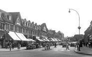
The photograph gives an unusual perspective in that the exit from the bridge and the High Street beyond appears to be restrictive for both traffic and pedestrians.

In an area of outstanding beauty and ancient and quaint villages, its hard to be noticed.

Roads pass by leading to Dunsop Bridge and Slaidburn. The young John Bright attended school here to improve his knowledge and physique.

Our photographer is standing on Doctors Bridge over the Bridgewater Canal, and High Street runs left and right from the top of the square.

A lane leads left to the church and manor house, and to the right is Burycroft, which leads to the medieval bridge and then Abingdon.

We are upstream of the bridges. Nag's Head Island is in the centre with its hotel fronting the bridge, and Stevens's Boatyard are the white buildings to the left.

Here we see the river bridges and Nag's Head island, which separates the main river on the right and the back water on its left.
Places (17)
Photos (40)
Memories (1924)
Books (2)
Maps (520)

