Places
2 places found.
Those places high-lighted have photos. All locations may have maps, books and memories.
Photos
3 photos found. Showing results 541 to 3.
Maps
29 maps found.
Books
1 books found. Showing results 649 to 1.
Memories
1,365 memories found. Showing results 271 to 280.
Trevelyan Road Tooting
I was born on 8th May 1945 (the day the war ended) at 61 Trevelyan Road Tooting. My mum told me that there was a heatwave on the 8th May and whilst she was trying to get some rest there was a street party going n which she ...Read more
A memory of Tooting in 1945 by
Hop Picking
My memories of Rolvenden will never be forgotten. I was eight years old, we lived in Brighton on the south coast, but every year our families would go hop picking at Little Holden farm. The farm was owned by Mr/Mrs Hilder - they ...Read more
A memory of Rolvenden in 1945 by
My Childhood In Meopham Green
I came to live in Meopham in May 1953 when I was 5 months old. I lived in a house called Kesteven right on the bend in the road at Meopham Green. Derham's the bakers was opposite, where Ken Derham used to bake all ...Read more
A memory of Meopham in 1953 by
Langley High St '60
Lived here during that time and it's nice to see the old photos as I remembered them.
A memory of Langley
Steam Trains
If I was out with my mother in the town as a small boy in the 1950s, I would pester to go to the station to see the steam trains through the railings. The journey home would take us up Windmill Hill past Enfield Chase station, but you couldn't get as near the engines there.
A memory of Enfield by
A Wonderful Time In Copper Street
My name is Carole McCarthy (nee MALONE) I was born in December 1951 in a maternity unit on Rochdale Road near to the Embassy Club. I lived in Copper Street in Collyhurst which had Barney's at the bottom of the ...Read more
A memory of Collyhurst by
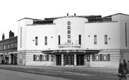
The Odeon
I remember going to The Odeon on Saturday mornings with my cousins. My family lived in Stephenson's Way then before we moved to Chelveston Drive. It was a long walk from what was The Lodge Park Estate and we'd go in a gang and replay the ...Read more
A memory of Corby in 1950 by
Inholmes
My aunt and uncle became the caretakers at Inholmes after it was converted to offices. I remember the magnificent staircase which had a huge eagle as a newel post. The range in the kitchen was the biggest I have ever seen, and the ...Read more
A memory of Burgess Hill in 1952
Blyth Then And Now
I was born in Newsham in 1952 and then moved to Malvins Close shortly after my sister Joyce was born at the end of 1953. I t was a great place to live and Ken Dawson and I roamed all over the place: the beach, ...Read more
A memory of Blyth by
Country Memories
I was born at Caroland Close and then moved to Bridge House next to John Childs garage; in those days owned by my grandad, Mathew Ward, where my mother worked in the office. My cousins lived nearby and great fun was had in ...Read more
A memory of Brabourne Lees in 1955 by
Captions
918 captions found. Showing results 649 to 672.

Here we see the top of the High Street, which is little changed today.The porchway on the left belongs to the Moot Hall, which was the town hall until 1974 and is now open to the public.

Fore Street and the triangular medieval market place are the heart of the town: here we see the south side, behind the Market House's stand of horse-drawn cabs.

with houses on both sides that gradually spread between the railway station at the north end of the village to a group of fishermen's houses built in the lee of a promontory at the south end – we can see the

Here we see the 13th-century Buddle Bridge (centre) and the buildings of Bridge Street which crossed it until demolitions for road widening in 1913.

We are now close to the lock, and can see the pound lock constructed in 1802, albeit with renewed lock gates or paddles.

On the right you can see the Nissen huts put up in the 1939-45 war for soldiers and the Home Guard, who were based here to keep supplies flowing during the war years.

Here we see the By Brook flowing placidly past the rows of exquisite cottages, with their steep stone-slated roofs and dormers. A man sits on the bank with his granddaughter enjoying the tranquillity.
The boat, with two men relaxing beneath their drying life jackets, represents a local variation from a standard type of craft (see the introduction).

Here we see the Grammar School from another angle, looking from East Road back into the city.

Here we see the area at the start of the West End Pier.

Here we see the top of the High Street, which is little changed today.The porchway on the left belongs to the Moot Hall, which was the town hall until 1974 and is now open to the public.

In this picture we can see the winch mechanism and cables of the ferry; it looks as though it will be a while before a crossing is made.

The impoverished duke died here in 1820, though not before he had taken the child in his arms to see the sea, telling locals 'one day she will be your queen'.

We can see the heavy industrial scene, the chimney stacks and the Courtaulds building in the distance (left).

In this view we can see the squat tower and castellated wing designed by George Devey for Lord Dunraven and built in 1886-88.

It was the wool trade that built the town, with its seething market and vast numbers of ships.

Here we see the busy High Street in the days long before it was pedestrianised. The large building at the end of the road is the impressive Shire Hall, built 1789-1791; it serves as the courthouse.

The Garden of Rest is on the left of this photograph, in which we can also see the colonnade which enabled visitors to shop under cover all down one side of the Pantiles.

Here we see the River Ceiriog, which is also the border between England and Wales: the cameraman is on the Welsh side.

At Parkmill we can see the earth bank or pale, with its wall and inside ditch, which marks the boundary of the deer park known as Park le Breos. The medieval deer-park was divided into three farms.

We can just see the church spirelet.

Can you see the two motor bikes and sidecars in our photograph?

The school was nearby and the children could see the memorial from the school yard, and workmen going to Bearpark Colliery passed it on their way to work every day.

From this favourite picnic spot, we can see the parish church standing proudly in the centre of the picture with the trees to its right covering the new market and car parks.
Places (2)
Photos (3)
Memories (1365)
Books (1)
Maps (29)

