Places
17 places found.
Those places high-lighted have photos. All locations may have maps, books and memories.
- Bridge End, Oxfordshire
- Bridge End, Lincolnshire
- Bridge End, Essex
- Bridge End, Bedfordshire
- Bridge End, Clwyd
- Bridge End, Warwickshire
- Bridge End, Surrey
- Bridge End, Durham (near Frosterley)
- Bridge End, Northumberland (near Hexham)
- Bridge End, Hereford & Worcester (near Tirley)
- Bridge End, Hereford & Worcester (near Bosbury)
- Bridge End, Shetland Islands
- Bridge End, Cumbria (near Carlisle)
- Bridge End, Northumberland (near Hexham)
- Bridge End, Devon (near Kingsbridge)
- Bridge End, Devon (near Sidmouth)
- West End, Yorkshire (near Pateley Bridge)
Photos
40 photos found. Showing results 241 to 40.
Maps
524 maps found.


Books
2 books found. Showing results 289 to 2.
Memories
1,914 memories found. Showing results 121 to 130.
Sunny 1950''s Sunday Mornings
I have many memories about the old St Mary's Church. Until I started thinking of them I realised that I have not got one involving a rainy day apart from when my Grandad was buried in the churchyard. He was ...Read more
A memory of Clayton-Le-Moors in 1954 by
A History Lesson
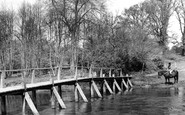
I have lived nearby for 10 years and this place eluded me for a while. Tancreds Ford is still a ford but the bridge is the modern equivalent. The reason I am posting this is because it was on the old smugglers route! Contraband ...Read more
A memory of Frensham by
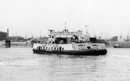
Woolwich Ferry
There has been a ferry at Woolwich for many centuries but the people of Woolwich complained in the 1880s that West London had free access across the River Thames by bridges so why couldn't they have free travel? The river was too ...Read more
A memory of Woolwich by
Air Raids
These memories are as fresh in my mind as if they happened last week. Boston had its share of air raids, the first one was on a rainy Monday, it was July, the first day of our summer school holidays. It would be about 7.15 am when we ...Read more
A memory of Boston in 1940 by
Happy Days 1950s And 60s
I was born and brought up in Weaverham until I left to move to Altrincham with my new wife (and job). Over that 20 year period I have so many happy memories; too many to record in 1000 words. Lived in Lime Avenue all ...Read more
A memory of Weaverham by
The Sun
The building on the left is the Sun pub, which we used to visit when in the sixth form at Stanborough school in the 1970s . Our teachers used it too as it wasn't far from our school so we used to go there more on weekend evenings... We ...Read more
A memory of Lemsford
School At Burslem Junior Tech
I lived in Blythe Bridge and travelled to school at the Burslem Junior Technical College in Moorland Road, Burslem over a period between 1943 to 1945. The journey by train on the old loop line was a lot of fun. I ...Read more
A memory of Burslem in 1944 by
My Memories Of Selly Oak And Bournbrook
I was born Anne Shirley Crofts back of 622 Bristol Road (opposite where Aldi is now) in July 1944, brother Ronnie was born 1940, sister Vivienne was born 1942, and Alan was born 1947, between Riverton Road ...Read more
A memory of Selly Oak in 1954 by
Lawrence Family In East Molesey
On a holiday from Australia, today my husband and I visited East Molesey & Hampton Court. My mother's paternal family were the Lawrence's - Edward was a master butcher and had a shop in 156 Walton Road (now ...Read more
A memory of East Molesey by
Bicycles And A Happy Hunting Ground.
Being the offspring of parents otherwise engaged, and only partially supervised by a succession of Nannies, whose only concern was that we should be clean and respectably dressed when we got up to mischief, ...Read more
A memory of New Milton in 1950 by
Captions
1,770 captions found. Showing results 289 to 312.

When digging foundations for the footings on the far side of the railway bridge the Victorian engineers discovered the remains of a Saxon fortification built in AD 915 by Queen Ethelfleda

This view was taken from the top of Brunel's railway viaduct and looks down New Road to the bridge and the beginning of the High Street.

This bridge is a railway bridge, and is now part of the west coast main line.Another railway bridge (to Blackburn) can be seen in the distance.

In this village churchyard there is a 19th-century memorial to thirty hop pickers who drowned when their cart slipped over a crumbling bridge and dragged them into the depths of the River Medway.

This splendidly atmospheric view along the High Street looks across towards the great medieval minster church which dominates the city and the countryside for miles around.

The car carrying vehicles and foot passengers usually took up to four minutes to cross from one side to the other.

This wonderful nostalgic photograph shows steam engine 'black 5', the work-horse of the LMS region, heading south with non-corridor stock on a local, probably to Bamber Bridge and on to Blackburn.

In 1831 there were only 150 people living in and around Consett.

The mill could take advantage of the canal for carrying its grain and flour all over the country.

The masts of sailing ships are visible beyond the bridge, and a fine collection of rowing boats can be seen around the boathouse.
This bridge is a railway bridge, and is now part of the west coast main line.

Anchor Wood is a narrow band of trees with a pleas- ant walk overlooking marshy ground downstream of the Long Bridge and at the foot of Sticklepath.

The Union Canal Bill was approved by Parliament in 1793, and work began in 1794, reaching Fleckney in 1796.

In celebration of the new crossing that carried the railway over the river, the 18th-century sandstone inn we see here was renamed The Severn Bridge Hotel in 1879.

Both the 800-tonne Swing Aqueduct and the swing road bridge have been opened to allow the passage of a steamer on the MSC.

This splendid branch railway ran from Ulverston to Newby Bridge and Lakeside at the foot of Windermere.

This was not only a freight line for the reservoirs, but also a passenger railway between Pateley Bridge and Lofthouse from 1901 to 1929.

A lane leads left to the church and manor house, and to the right is Burycroft, which leads to the medieval bridge and then Abingdon.

Roads pass by leading to Dunsop Bridge and Slaidburn.

In an area of outstanding beauty and ancient and quaint villages, its hard to be noticed.

The photograph gives an unusual perspective in that the exit from the bridge and the High Street beyond appears to be restrictive for both traffic and pedestrians.

The River Medway traditionally separates the Men of Kent on its east side from the Kentish Men on the west, but bridges such as this one unite the two 'tribes'.
Roads pass by leading to Dunsop Bridge and Slaidburn.

We are upstream of the bridges.
Places (17)
Photos (40)
Memories (1914)
Books (2)
Maps (524)

