Photos
Sorry, no photos were found that related to your search.
Maps
9 maps found.


Books
Sorry, no books were found that related to your search.
Memories
26 memories found. Showing results 1 to 10.
Middleton Family
Hi - My family history research finds that my mother Isobella Stephenson was born in Houghton in 1917. Her family may have been in the pub buisness, but her father Harry John Middleton worked for the railways. They ...Read more
A memory of Houghton in 1910 by
From Woodland Road To Cheshire Via The Penllwyn
On June 11th 1952 in the front downstairs room, (or close by) of 14 Woodland Road I let out my first cry. My early days of Pont are blurred, because they were not happy days. But I do remember ...Read more
A memory of Pontllanfraith by
Bombing Raids In 1940
Bristol's premier shopping centre was turned into a wasteland of burned out buildings after major bombing raids in 1940, during the Second World War. Bridge Street Summary Bridge Street ran from High Street, rising up a ...Read more
A memory of Bristol by
Bristol Blitz
The High Street - the scene of many stirring events in Bristol's history and the heart of the city - was destroyed and lost forever during the Second World War. As a city with docks and industry at its heart, Bristol was a natural ...Read more
A memory of Bristol by
Looking For Old Memories
Both my parents lived in Woodford for most of their childhood. Mum lived in Uplands Road, and Dad lived in Chalford Walk. They got married in Broadmead Baptist Church in 1964. I'm trying to find any records, memories anything at all that might relate to either of them. Can anyone help?
A memory of Woodford Bridge by
On Our Way To Longleat.....
After walking the footpath from Rodden Farm we would end up on the main Frome /Warminster road, not far from the start of Friggle Street. This was our route to Longleat we often took on foot during our school holidays. ...Read more
A memory of Elliots Green in 1980 by
Moston
My grandparents, Horald and Edith Hughes, lived in Moston Cottage, Booley. Also living in the cottage were 3 of their sons; John, Douglas and Tony. My father, Basil, was no longer living at home. John and Douglas worked on the ...Read more
A memory of Moston in 1957 by
Palmers Green
My grandmother lived at 50 Old Park Road, opposite Bloomfield Park, and I went to school at Franklin House School in Palmerston Road from 1955 to 1960, then the Winchmore Hill Collegiate School from 1960 to 1962. I used to ...Read more
A memory of Palmers Green in 1959 by
Growing Up In Holbeach St Marks (The Marsh)
Although I was actually born in Holbeach Bank, and spent the first 3 1/2 years of my life in Holbeach St Matthews, I spent my childhood in Holbeach St Marks. My mother and father Ray and Greta ...Read more
A memory of Holbeach St Marks in 1955 by
Broadmead The Horsefair Bristol Bs1
This 1960s photograph of Bristol's Horsefair in Broadmead shows the two swish large department stores of Lewis's (far right of photo) and and its huge neighbour Jones. (Lewis's now John Lewis no connection and ...Read more
A memory of Bristol in 1953 by
Captions
15 captions found. Showing results 1 to 15.

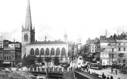
Broadmead runs between Union Street and Penn Street, and was a part of the regeneration of the city centre following the destruction of the Second World War.

The broad expanse of the A24 London Road heading towards Stonecot Hill and Morden is lined with parked cars and bicycles outside the shops.

Ardleigh Green Road reaches the Southend Arterial Road (A127) and beyond is Squirrel's Heath Road heading for Harold Wood.

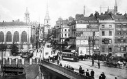
The centre was heavily bombed during World War II, and a new shopping area was built at Broadmead, beyond the tower.

Continuing uphill past the end of The Paragon and at the junction with Guinea Lane, Roman Road heads for the junction with a steeply climbing Walcot Street and London Road.

This is the extremely busy A15 main road heading north to Folkingham, Lincoln and eventually the Humber Bridge and south (the way we are facing) to Market Deeping and Peterborough.

Immediately opposite is the Broadmead Hotel, later to become the Picture House (the Torbay Cinema).

The row of council houses is at Broadmead (left foreground).
This is the extremely busy A15 main road heading north to Folkingham, Lincoln and eventually the Humber Bridge and south (the way we are facing) to Market Deeping and Peterborough.

From the Crown and Anchor pub on the left, the A6 trunk road heads away to Hadley Wood and on to Coventry, while on the right, the gleaming frontage of Clark's shoe shop reflects the passing scene.

The Star pub stands at the junction of the Crawley road, leading to the left, and the old Roman road heading towards London via the Caterham Valley.

This view is taken on the Portsmouth Road, now the A3100, with Church Road, the A286 Midhurst and Chichester road, heading to the left of the painted brick shop on the corner, which is now an Alldays

Two phases of Victorian expansion are shown here in this view along the Brighton Road heading south-east from the town.

The road heading off to the right leads to St Wilfrid`s Church, and not unsurprisingly is called Church Road.

At the top of the road was the Broadmead Hotel, the future site of Paignton's Picture House (the Torbay Cinema) which followed.

