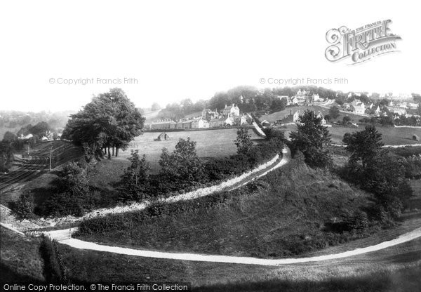
Walls Quarry 1901 & The Cresta Run In 1963
A Memory of Brimscombe.
This is a very rare photo which is taken from a grass slope below a small coppice in a valley known as the "Moors" from the bottom of what is now called Orchard Lane.
This unusual photo looks up the lane, (from its nearest lowest point), SE towards the Brimscombe Hill & Walls Quarry.
The lowest point is actually underneath the railway bridge, just emerging as a stone wall, (bottom left).
The railway lines lead towards Brimscombe Halt ,(on the mid left edge), on the UP line to Swindon and is part of the GWR, Swindon to Gloucester section through the Golden Valley..
As the lines go out of view they will go under the Brimscombe Hill Tunnel, (which is said to be the shortest in the UK, barely 30 foot long) and immediately behind the tunnel is a road bridge, (just below the current day entrance to Brimscombe C of E school) which takes the winding road up and around Brimscombe Hill to pass across the entrance at the top of Orchard Lane.
Down at the Bottom of the lane through, (the out of sight), railway bridge is the Stroud Water Canal and Gough's Orchard lock, (with the canal following the same direction as the rail line), towards the Port of Brimscombe.
If you went through the bridge and headed down the toe path the other way, towards Stroud, you would have passed the Abdella Boat Building Co, which was still in operation at the time of the photo
The light coloured track merging off orchard lane at the bottom looks wider than today, (and could have been a cart track when taken), and today is a narrow tarmaced path which leads up through the Moors to Swells Hill and Bagpath Lane.
The greatest change in this photo is the foreground of the field above and edging Orchard Road up towards the row of houses at the field top edge.
This row of houses is on Victoria Road and all the houses still exist in 2020.
The field with the haystack belonged to two WW1 widows who lived in the largest house on Victoria Road called "The Manse". Some time in the 30s they sold the whole field to the SDC for council housing and created Albert Road making a rectangular road with semi detached council houses, on both sides of the new road. The estate still exists today
Finally the small trees edging Orchard Lane were full grown when I arrived as a 5 year old in 1958 to live at No 7 Victoria Road with my parents 2 brothers & a sister.
The trees are so tall today that field, (which was our "play field") would obscure all the houses including a small extension to that estate in the 60s.
I believe that ALL the houses that can be seen still exists to day, and Walls quarry, (which is the only level part of Brimscombe Hill up to Minchinampton Common), is the only flat bit.
The facing bank at the bottom of Orchard Lane remains as wild today as it was rough pasture then. The Trinity C of E Church is hidden in trees at the top of Orchard Lane as it is today and the "Steep Road", (a shortcut to Burleigh and "Devils Bridge") is already built as is the road up past the church to the Walls Quarries who produced Cotswold stone for house building.
Finally the photo is some what misleading in its prospective as the open field belies just how steep this lane is very near 1:1 and in the winter of 62/63 this lane was full of compact snow and covered in ice. It became the Orchard Lane " Cresta run" the fastest sleigh run in the valley.
Add your comment
You must be signed-in to your Frith account to post a comment.
Add to Album
You must be signed in to save to an album
Sign inSparked a Memory for you?
If this has sparked a memory, why not share it here?


Comments & Feedback
Be the first to comment on this Memory! Starting a conversation is a great way to share, and get involved! Why not give some feedback on this Memory, add your own recollections, or ask questions below.