Places
17 places found.
Those places high-lighted have photos. All locations may have maps, books and memories.
- Bridge End, Oxfordshire
- Bridge End, Lincolnshire
- Bridge End, Essex
- Bridge End, Bedfordshire
- Bridge End, Clwyd
- Bridge End, Warwickshire
- Bridge End, Surrey
- Bridge End, Durham (near Frosterley)
- Bridge End, Northumberland (near Hexham)
- Bridge End, Hereford & Worcester (near Tirley)
- Bridge End, Hereford & Worcester (near Bosbury)
- Bridge End, Shetland Islands
- Bridge End, Cumbria (near Carlisle)
- Bridge End, Northumberland (near Hexham)
- Bridge End, Devon (near Kingsbridge)
- Bridge End, Devon (near Sidmouth)
- West End, Yorkshire (near Pateley Bridge)
Photos
40 photos found. Showing results 81 to 40.
Maps
524 maps found.


Books
2 books found. Showing results 97 to 2.
Memories
1,914 memories found. Showing results 41 to 50.
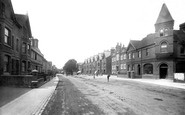
The Pyramid Roof Has Gone!
This is the view from near the iron railway bridge (built c1859) looking back towards the town. The pyramid shaped roof was in place up until the end of WWII. Between then and now it has been removed but I do not know why! ...Read more
A memory of Horsham by
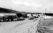
Sun, Sea & Sandhills At Gronant
I remember going on our holiday in dad's car to Nan & Grandad's holiday bungalows, driving over the railway bridge and on to what I always knew as Gronant (The Warren). The first thing we would see would be the ...Read more
A memory of Gronant in 1966 by
Island Cottage
My nanna and grandad Noden lived at Island Cottage. Grandad was a bridgekeeper along with Jack Powell and Syd Bebbington at Acton swing bridge from 1945-1960. There was an enormous flood in 1946 when my grandparents were the ...Read more
A memory of Acton Bridge in 1955 by
Doon The Brae In 1950
When my family moved here I was only 7 and there was only a cottage on the left at bottom of Brae and a row of four terraced houses on the left, they were holiday homes for my grandmother and her sisters. We lived there with ...Read more
A memory of Mid Calder by
Featured Buildings.
The large building on the left edge of the photograph is Ruswarp Mill. A mill has been here since Saxon times and the first written record of this mill appears in the Domesday book. The name Ruswarp may have originated from the ...Read more
A memory of Ruswarp by
Fair And Lake Wandle Park, Croydon
A travelling fair each summer here was both a delight and a way to earn a few shillings when the fair ended. I would help dismantle the rides and stalls, working hard from morning to evening for about five ...Read more
A memory of Croydon in 1947 by
My Memories Teresa Shackell/ Torrington.
I'm Teresa Shackell/Torrington I remember very well my nana used to work washing the dishes and I used to go regularly over to the three salmons hotel and help her she was in her 90s then she never gave up her ...Read more
A memory of Usk by
Hornchurch, Wingletye Lane, Photograph C.1950
I lived in Glanville Drive, a residential road off Upminster Road about 100 yards to the west of Wingletye Lane, for the first part of my life from 1947 so I knew the area well. The building on the ...Read more
A memory of Hornchurch by
Woodhall Parade, Wingletye Lane, Hornchurch
I lived in Glanville Drive for the first part of my life from 1947. Out nearest post office was in Woodhall Parade, just over the railway bridge in Wingletye Lane, One thing that sticks in my mind is that ...Read more
A memory of Hornchurch by
Bailey Bridge Pontoon Canal Cruisers.
I built the boat shown on the right hand side of the photograph. Bailey Bridge pontoon MKVI N0.19053 was manufactured by Gee Walker & Slater Ltd, Uttoxeter Road, Derby and sent to Engineers Stores, US ...Read more
A memory of Great Haywood in 0 by
Captions
1,770 captions found. Showing results 97 to 120.

At the junction of Gold Street and Bridge Street, with The Drapery to the right, this view looks west from the end of Mercers Row.

This view looks south-westwards from Broad Ledge to Long Ledge (foreground) below Gun Cliff to the Guildhall (top right), the Fossil Depot beside Buddle Bridge and the Assembly Rooms (centre), with the

In this view the northern wing, which turns the corner into Bridge Street, is still virtually brand new.

The Square lies at the north end of the Long Bridge.

It stands at the end of a narrow muddy creek, the haunt of the heron and kingfisher, that winds a course between luxuriant woodland.

Amberley church lies between the castle and the village at the western end of a ridge of high ground, which is about one mile north of Houghton Bridge.

This photograph shows the Cannon Street end of King William Street, which heads south-east from the Mansion House towards London Bridge.

Its rugged stone bridges and its proximity to the Pennines make it a most picturesque line.

Just behind the camera at the north end of the town lies Yarm Bridge, reminding us that for centuries the River Tees was navigable; Yarm operated as an important port, until it was superseded later by
The Square lies at the north end of the Long Bridge.

Ware is packed full of interesting buildings and streets, but nothing it has to offer surpasses Amwell End.

By 1900 the tenements appear; their gable-ends were obviously a popular advertising site.

This renowned thoroughfare, a continuation of Oxford Street, links the West End with the City.

The Exel Bowling Lanes replaced it and live entertainment moved to the end of the pier.

After a serious fire in 1975, the 18th-century building with the black cross facing us at the end of Bridge Street, formerly the Crown Inn, was demolished; this caused a major outcry.

Serving both a rural area round about, and hundreds of overseas ports by way of trade, Plymouth reached its mercantile heyday in Victorian times.

This view shows the junction of Boar Lane and Briggate, looking towards the Corn Exchange.
This view shows the junction of Boar Lane and Briggate, looking towards the Corn Exchange.

The road is named after the Tontine Hotel, which was built in 1783 to accommodate visitors coming to see the new bridge.
This view shows the junction of Boar Lane and Briggate, looking towards the Corn Exchange.

The weir, a mile up the river from Totnes Bridge, was built in 1581 to provide water for the town mills, and marks the end of the freshwater Dart - below here the river is tidal.
Serving both a rural area round about, and hundreds of overseas ports by way of trade, Plymouth reached its mercantile heyday in Victorian times.
Serving both a rural area round about, and hundreds of overseas ports by way of trade, Plymouth reached its mercantile heyday in Victorian times.

Five years after the end of the Second World War, there was still much evidence of the severe bombing around the cathedral.
Places (17)
Photos (40)
Memories (1914)
Books (2)
Maps (524)

