

Places
17 places found.
Those places high-lighted have photos. All locations may have maps, books and memories.
- Green Street Green, Greater London
- Green Street Green, Kent
- Green Street, Essex
- Bodle Street Green, Sussex
- Wicker Street Green, Suffolk
- Broad Street Green, Essex
- High Street Green, Suffolk
- Green Street, Gloucestershire (near Gloucester)
- Green Street, Hereford & Worcester (near Upton upon Severn)
- Green Street, Hertfordshire (near Borehamwood)
- Green Street, Gloucestershire (near Upper Cam)
- Green Street, Hertfordshire (near Bishop's Stortford)
- Green Street, Hereford & Worcester (near Worcester)
- Green Street, Sussex (near Billingshurst)
- Green Street, Sussex (near Bexhill)
- Wickham Street, Suffolk (near Clopton Green)
- West Street, Kent (near Woodside Green)
Photos
8 photos found. Showing results 1 to 8.


Maps
74 maps found.


Books
Sorry, no books were found that related to your search.
Memories
646 memories found. Showing results 1 to 10.
Green Street Green
My Dad, Sandy Leonard was the Group Scout Leader of the 1st Green Street Green Scout Group in the 1960’s. We lived just up from the Crescent Way. Best to all Peter
A memory of Green Street Green by
Mandrake Road
My siblings and I were all born at Weir maternity hospital in Balham, we lived on Mandrake road and we all went to Fircroft primary school opposite our house. I was at Fircroft from 1976-1982. Mr. Chaimings was the headmaster then, Mr ...Read more
A memory of Tooting by
Reflections Of My Life
I was born in Argoed Blackwood in a condemned house by candlelight in 1950 We moved to 26 Underwood road Oakdale when I was still quite young. I can still remember so much from all those years ago. The Bic. Browns, Parry, Yem ...Read more
A memory of Oakdale by
Talke A Forgotten Village
As you proceed north along the A34 towards the Cheshire border you will approach Talke traffic lights and on the left and right side of the road there are two areas of grassed land. This grassed area was once the village of ...Read more
A memory of Talke in 1959
Newarthill 1950/60s Tosh And I Part 2
Like everyone else growing up in Newarthill, life wasn’t easy, as times were tough in the 50s and 60s and I suppose in many ways it is today. But back then people really had nothing, but one thing I do remember - ...Read more
A memory of Newarthill by
A Schoolboy's View Of Bexleyheath In The Early 1950s
I went to school in Bexleyheath between 1950 and 1954. I believe the school was in Pelham Road but I can't be sure. Maybe there was a separate infants department in North Street? My first (very ...Read more
A memory of Bexleyheath in 1950 by
Ryders Folklore
These cottages are now known as Ryders, but it appears that in Edwardian times the place (or maybe this corner) may also have been known as "Seven Trees Well": I have a postcard with this picture on it sent on 7th May 1906 to a ...Read more
A memory of Okewood Hill in 1900 by
The Coronation
I was only 3 years old and we lived in Elthorne Rd just across the street from The Militia Canteen on the corner of Villier St. I do remember the flags and bunting draped across the front of the buildingl and the coronation childrens ...Read more
A memory of Uxbridge in 1952 by
Gants Hill Smiths Bus Stop
I used to live in Montreal Road, off Perth Road, and remember the bus-stop outside Smiths stationers. There was also a real butchers, greengrocers, shoe shop, Woolworths, banks, a small dress shop and later a Jewish ...Read more
A memory of Gants Hill in 1961
Growing Up In Burnham
In this year I was 5 years old, and just starting school in the church hall in Gore Road, which is the road in which I also grew up. I remember Burnham as a small, close-knit community, we went to church every Sunday, it was ...Read more
A memory of Burnham in 1962 by
Captions
165 captions found. Showing results 1 to 24.

The market originally took place on the Green, but was confined to the south side of it after the Chapel on the Green was built in 1805.
The market originally took place on the Green, but was confined to the south side of it after the Chapel on the Green was built in 1805.

The eight daily coaches would have passed the Bull and Horseshoes at Potter Street, the Queen's Head at Churchgate Street, the Green Man at Mulberry Green and the George at the end of the High Street.

Fair Green lies past the junction of Bell Street and Knight Street and of the site of the town pump.

This view is in the heart of the village, where Green Street meets the High Street at a small green with a 1920s War Memorial cross.

The eastern end of Bell Street is crossed by Knight Street, a wide road leading from Station Road to Fair Green where a market and fair have been held since the charter was granted in 1306.

The first village settlement was around a huge green beside the Car Dyke, a Roman ditch that connected Cambridge with Peterborough and the north.

Further west, the High Street meets Abingdon Road (right) and Steventon Road (left) in a small green.

From this elevated view point we get the impression of what must have appeared a somewhat green street.

Nowadays the green is edged with lime trees; attractive Georgian and later cottages surround it, and the Baptist Chapel of 1823 faces its north side.

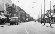
An open-top bus heading for Redhill via Epsom overtakes a lone cyclist outside the Green Man public house (right), with its swinging sign showing a figure dressed in forester's green.

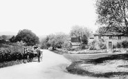
A herd of contented pigs rootle opposite the post office on the green which runs alongside a two-and-a-half mile stretch of the Romans' Stane Street.

Formerly named `Hill of St Thomas`, or `Hill Street`, it runs from St Thomas` Green to Market Street.

This is taken from the north end of the Green, looking south towards Hall Street, showing the wide expanse of the Green, where fairs are still held.

Looking down the street to the green hills of County Tyrone beyond.
Formerly named 'Hill of St Thomas' or 'Hilstret', it runs from St Thomas's Green to Market Street.

A view looking east along the green to Trinity College, with the Bank of Ireland on the left.

We are looking from the start of the High Street towards the green. A

Looking back over the Lawn towards Bear Street, the view is instantly recognisable today.

There was a great fire in 1600 in Gamlingay, and most of the buildings along Church Street were burnt down.

To the left, Crown Street runs up towards St Mary's and Greene King's brewery.

Bus shelters, one with a shopper waiting, occupy Tudor Square, once called Bally Green, at the end of Market Street, which is Dalton's main shopping street.

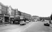
Local bus services used Terminus Street, and so did the Green Line and National Express.

The buildings to the left are the river side of Quay Street and served as port facilities for the town.
Places (17)
Photos (8)
Memories (646)
Books (0)
Maps (74)

