Merry Christmas & Happy New Year!
Christmas Deliveries: If you placed an order on or before midday on Friday 19th December for Christmas delivery it was despatched before the Royal Mail or Parcel Force deadline and therefore should be received in time for Christmas. Orders placed after midday on Friday 19th December will be delivered in the New Year.
Please Note: Our offices and factory are now closed until Monday 5th January when we will be pleased to deal with any queries that have arisen during the holiday period.
During the holiday our Gift Cards may still be ordered for any last minute orders and will be sent automatically by email direct to your recipient - see here: Gift Cards
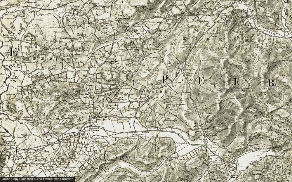
Historic Ordnance Survey Map of Skirling, 1904-1905

Taken from original individual sheets and digitally stitched together to form a single seamless layer, this fascinating Historic Ordnance Survey map of Langlawhill, Borders is available in a wide range of products, including prints, canvas prints, jigsaws, mugs, tea towels etc.
Buy a Print
Unframed, Mounted, Framed and Canvas prints in a range of sizes and styles.
 Size: 420 x 297mm (16.5 x 11.7")
View Sizes & Prices
Add to Album
You must be signed in to save to an album
Sign in
About This Map
- Original scale: 50000
- Year drawn: 1904-1905
- Series: Ordnance Survey Revised New Colour Series
- Series survey years: 1893-1898
- Map reference: rnc832207
- Learn about Revised New Colour Series maps
Explore the Revised New Map Series (Colour)
Surveyed and Revised 1842-1898. Published in colour 1897-1904. Scale is 1:50,000.
In late 1896, the Ordnance Survey concluded that sales of the new maps to civilians would help subsidise the costs, a consideration which helped drive forward production of the first colour one-inch map the following year. Even then, the debate continued, and some features, such as the use of green for woodland (which only appeared on sheets 1 to 73, north of the Preston to Hull line), were amended as the series progressed. Although the final results were something of a compromise between the often incompatible aims of the military, the Treasury and the Ordnance Survey, the Revised New Series in colour stands as an elegant portrait of late-Victorian Britain.
 Map")
The Revised New Map Series (Colour) is an immaculate record of a vibrant society on the threshold of a still greater period of development and urbanisation. It records countless reminders of the past, many of which were about to be swept away for good.
For local historians, this is the final record of your part of the country before the changes brought by the motor car. If your interest is genealogical, the series coincides with the 1901 Census, showing the landscape your ancestors inhabited.
Whatever your reason for being interested in your area’s past, prepared to be entranced by these maps – enlarged and combined to match the present-day OS Landrangers, they will reveal secrets of a familiar landscape you never knew existed.
