Places
Sorry, no places were found that related to your search.
Photos
Sorry, no photos were found that related to your search.
Maps
7,034 maps found.


Books
163 books found. Showing results 3,577 to 3,600.
Memories
22,912 memories found. Showing results 1,491 to 1,500.
Oldcotes & Langold
The Priories Historical Society based in Oldcotes are looking for any old photos, maps, books, documents to facilitate our research into this important archaeological area. The Priories have talks every month at Oldcotes Village ...Read more
A memory of Langold by
Valence Park
During the 1940's my Mother worked as a part time Park Keeper at Valence Park, I and my older sister spent many hours in the park, it was the safest place to be during an air raid, I remember the doodle bug hitting the houses in ...Read more
A memory of Dagenham in 1944 by
My Youth
I was born at Springend near Horbury in 1948, lived at 40 Northfield Lane, Horbury emigrated to Australia in 1961. I remember the Library, spent hours there reading the famous five books and secret seven, still do. Whites fish and chip ...Read more
A memory of Horbury in 1950 by
Growing Up In Stafford Until 1975
I grew up on the Weston Park Estate and my close friends were Ann Parker and Linda Jay, as we all lived a few doors away. We used to go to Riverside disco approximate 1970 and the Young Farmers disco on Friday ...Read more
A memory of Stafford by
County Oak Tushmore Sports And Social Club
So named because members were from north of Crawley on the main A23 Brighton Road, not big enough to be a village, but a hamlet stretching half a mile north and south of todays Manor Royal Estate ...Read more
A memory of Crawley in 1954 by
The Old School Memories
I attended Pengam school until 1945, when spotty Willliams was the head master, only a little man but he could swish the cane on you which I remember well. During the war we all had to carry our gas masks with us ...Read more
A memory of Pengam in 1940 by
Growing Up In The War Years In Prees & Whitchurch
Although I was born in Whitchurch [Bark Hill], we moved to Prees soon after. However, I was sent to stay with my grandmother most weekends and for a period I was sent to the Wesleyan school. My ...Read more
A memory of Whitchurch in 1940 by
Recollection Of June 1953
I recall receiving a Coronation Commemoration Mug, in my nursery school in June 1953. I was 5 at the time. My father was a resident Doctor in St. Michaels Hospital in Braintree. Does anyone know the name of the school ? ...Read more
A memory of Braintree by
Bombing Of Morland Avenue
Written by my mother when she was 70. She lived in Swaisland Road I think one of the things you would have noticed was the number of barrage balloons all around, high in the sky. The first sound of guns which we heard ...Read more
A memory of Dartford in 1945
Brooksby Hall Agricultural College, Leicestershire,England
Like Gwilym Evans I was enlisted into HM Forces in 1944, along with my twin brother. We were born in May 1926. Served with RASC as drivers first in Wiltshire, England, driving 3 ton ...Read more
A memory of Nantgwynant in 1949 by
Your search returned a large number of results. Please try to refine your search further.
Captions
9,654 captions found. Showing results 3,577 to 3,600.

The parish church of St James, Finchampstead was first recorded in the early 12th century. One of its later additions was the brick tower in 1720.

Newport has always been an important trading town, and at the height of its fortunes carried goods such as timber, malt, wheat and flour.

East of Market Deeping and joined to it is Deeping St James village. At its heart is this curious structure in medieval stone.

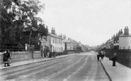
The Bishop of Winchester granted a weekly market here in the 13th century, and looking at this photograph of one of the village streets, little has changed since the mid 1950s.

This little town, on the Yorkshire/Lancashire border, has been famed for its potteries since Roman times. Coal mining and quarrying also sustained the population.

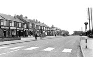
This is another view of the High Street, although here the road is much wider. The London Co-operative Society shop can be seen on the right.

Whickam is not noted for much save that it was the birthplace in 1748 of William Shield, musician and composer, who rose to become the Master of the King's Music.

The rugged nature and scale of the cliffs at Beachy Head, seen here to the east of the lighthouse, is clearly shown in this view.

The Romans had a settlement here at Ospringe.

A minimal circular fountain typical of the 1930s is Uren's only gesture to forecourt landscaping.

This is without doubt the best-known building in Ipswich: the Ancient House (or Sparrowe's House) and its incredible plasterwork.

We are looking east along a lively Brighton Beach towards the unfinished Palace Pier at the close of the 19th century.

To the left of the River Stour is the Bell Hotel; the town records report that the mayor 'presented King Charles II with a glass of sack at the Bell tavern door' when his Majesty rode in

The Warden Bay Caravan Park also had chalets, which we can just see at the top right of the photograph. Note the 5mph speed limit sign just inside the narrow gates.

This is taken from Old Kirton Road, looking towards the capped top of the mill, now Mill Close. The cottages are Victorian and Edwardian, and some of them may have been built for workers at the kiln.

The Dam is still the popular name for Clowne's reservoir at Harlesthorpe, north of the former coal-mining village.

The Derbyshire and Lancashire Gliding Club, based at Camphill, 1,360ft up on Hucklow Edge, had its finest moment when the World Gliding Championships, during which this photograph was taken, were held

The bus station managed to combine functionalism with aesthetics. The mosaic along its fascia measures 315?×?13ft, and consists of 16,000 hand-printed tiles. The artist was John Gordon.

Burton is considered by many to be one of the most picturesque villages in the Wirral, and it is enhanced by the wonderful panorama over the Dee Estuary to the hills of Wales.

It is interesting to note that the brick cottages in the centre have a timber-framed gable end, revealing a much older origin than the brickwork suggests.

The scene today would be very similar to that captured in the photograph, with crowds of people hunting for a good bargain.

Bath Road is an extension of the village, which grew with the wool trade in the 17th and 18th centuries. Until a by-pass came in 1990, it carried both the A36 and A361.

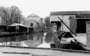
This is down-town Lydney in the days when books could be loaned from the newsagents for a few coppers a week via the Argosy Lending Library, and a liquid night out at the Fleece could be had for less than

St Luke's is a fine church in an equally well-proportioned village.
Places (0)
Photos (0)
Memories (22912)
Books (163)
Maps (7034)

