Places
Sorry, no places were found that related to your search.
Photos
Sorry, no photos were found that related to your search.
Maps
Sorry, no maps were found that related to your search.
Books
Sorry, no books were found that related to your search.
Memories
3,644 memories found. Showing results 31 to 40.
Looking Back
I was born in St Peters St, Islington, 1935, bombed out late 1943, with nowhere to go, had a makeshift home in Aloysius College for a time until we were given a place in 4 Montague Road, Honsey, N8, that's where I knew what it was like ...Read more
A memory of Hornsey in 1944 by
School Days
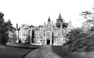
Before becoming the home of George Harrison of the Beatles, Friar Park was run as a school by sisters of the St. John Bosco order. This was my first school and I remember having to walk all the way to the main door along the ...Read more
A memory of Henley-on-Thames in 1960 by
The Hut Grounds
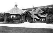
Seeing this photograph reminded me of the name by which we used to know this site, namely 'The Hut Grounds'. Nowadays it is mostly referred to as 'Bradda Glen Cafe', but in my childhood it was 'The Hut Grounds'! In the height of ...Read more
A memory of Port Erin in 1962 by
Ffoselig Farm
Lived on a wonderful farm. The Welsh farmer living there still to this day runs this farm which has been in his family for generations. Would love to go back there again. Very fond memories of hay making, feeding cattle and ...Read more
A memory of Maesymeillion in 1994 by
Coombes Of Church Farm
I believe my Great Grandparents Annie and Maurice (Frank) Coombes lived and farmed at Church Farm during the 1920s. My father Thomas (Aubrey) Coombes used to spend most of his school holidays there as a boy. This ...Read more
A memory of Sixpenny Handley in 1920 by
Living In North Boarhunt 1965 1968
My parents moved to North Boarhunt in 1964/65. We lived at the top of Trampers Lane - sideways to what was then Doney's Garage. Our house was called "Tryfan". I went to Newton Primary School and have very ...Read more
A memory of North Boarhunt in 1965 by
The Bell Inn
I moved to Outwood 10 years ago to work at the Bell Inn. With its own unique charm I was taken with it from the moment I entered. Originally run by a Mr. John Lane the pub was sold a few years later to a private investor and was sold ...Read more
A memory of Outwood in 2008 by
Visiting This Shop
I started Gainford School in 1954 & remember Miss Browns little shop crammed full with habberdashery, stockings (nylons) hankies, knitting-wool, etc., everything you could possibly want - an oasis in this small village. ...Read more
A memory of Gainford in 1955 by
Early Years Of My Life
I was born in 1936 in Shipley nursing home and we lived at 1 The Green, Micklethwaite until 1944. My father died in 1941 and my mother was left with me and brother John, surname Walker, to bring up on her own. ...Read more
A memory of Micklethwaite in 1930 by
Princess Christian College
26 Willbraham Road used to be the home of the Princess Christian College of Nursery Nursing where I spent a happy if hectic 18 months - in those days my surname was Smith. We used to be able to go out through the back ...Read more
A memory of Manchester in 1968 by
Captions
1,151 captions found. Showing results 73 to 96.

The name means simply 'long street', and the village is spread along the main road, originally the Roman road running from London to Caistor St Edmund, the Roman town just south of Norwich.

A scene which is familiar to us all, even in the rush of today's 'rat-run' world. Plodding cows head for the milking parlour, guided by the farmer on his wobbly upright bicycle.

Formerly named `Hill of St Thomas`, or `Hill Street`, it runs from St Thomas` Green to Market Street. Note the `parked` cars to the left and the busy traffic!

At the western end of Westgate, we see very clearly how the trees planted at either side of the road created a very attractive avenue effect when entering the town in this direction.

The late 19th-century industrial face of the village percolates through the photograph, providing a dramatic contrast to Church Lane, which runs almost picturesquely away to the right of the cross.

An evangelical mission wagon lies idle in the quiet village street. This large parish runs along the eastern bank of the Severn for several miles.

A feature of several East Devon villages is a brook running alongside a main street.

Undercliff Drive runs the long distance eastwards from Bournemouth's Pier to the pier at Boscombe.
South of Bakewell, the river runs through elegant parkland that forms the grounds of Haddon Hall. In this view, the lush nature of this wonderful valley is clearly illustrated.

This building was once a pin factory and dates from the mid 16th century.

The railway at Datchet runs between the Thames and the village centre. Datchet is mentioned in Shakespeare's 'Merry Wives of Windsor' and Jerome K Jerome's 'Three Men in a Boat'.

Built in the late 1700s by 'Capability' Brown, who is usually better known for his gardens, this extravagant mansion was demolished in 1954. Today the M54 motorway runs right over the site.

Running above the course of the Flete brook, this broad street, now one of Torquay's premiere shopping malls, was constructed in 1865 to replace the narrow lane of slums and fishermen's cottages that originally

The Furness Railway paddle-steamer 'Philomel' entering Fleetwood. Built in 1899 for the General Steam Navigation Co, the paddler was purchased by the Furness Railway in 1907.

A source of water was essential for the use of the monks and the parishioners. The small River Eea (or Ay) is the largest stream in the area, and it runs through the centre of Cartmel.

This view of the rear of the Town Hall is taken from Town Hall Gardens.

This photograph shows Cornmarket Street running down to Carfax, with the outline of Tom Tower dominating St Aldates on the far side.

Westover Road, with its clean-cut and dramatic lines, runs from the direction of the sea to the square; it is still an important shopping street.

Northgate Street runs north from The Cross; it is here, in the basement of No 23, that remains thought to belong to the headquarters building of the XXth Legion can be seen.

St Thomas Becket church is at the east end of Cliffe High Street, which runs west to cross the Ouse into School Hill and Lewes proper.

The Guernsey Steam Tug & Trading Co's 'Assistance' appears to have been on a luggage run, as cases and trunks are being unloaded and placed upon a cart.

Some of the water off the surrounding high ground runs through Glen Rushen and Glen Mooar before entering the sea by way of Glen Maye.

This is the view from Rochester Castle looking across the River Medway.
Lightermen pose on barges at low tide at one of the many working wharves.
Places (0)
Photos (0)
Memories (3644)
Books (0)
Maps (0)

