Places
2 places found.
Those places high-lighted have photos. All locations may have maps, books and memories.
Photos
11 photos found. Showing results 121 to 11.
Maps
10 maps found.
Books
Sorry, no books were found that related to your search.
Memories
102 memories found. Showing results 61 to 70.
Happy Days At Elmcroft Crescent
Hi, I came across this site by accident but I am delighted to recap on happy days spent living in North Harrow. We lived in Elmcroft Crescent off Headstone Lane and attended the comprehensive school at the ...Read more
A memory of North Harrow in 1957 by
Eastville Park Bs5
Eastville Park is a large park with a small lake, just to the east of the M32. The lake at Eastville Park was instigated as part of a social scheme by Ernest Bevin (a well respected westcountryman) who later became Minister of ...Read more
A memory of Bristol by
Gascoigne Road
I was born in Gascoigne Road in 1946, right opposite the school, 2 doors from Molly's sweet shop. My sisters Brenda and Betty along with our parents Rose and Arthur Cox. I have wonderful and happy memories of our life in Gascoigne ...Read more
A memory of Barking by
My First Day At School
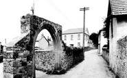
The old arch extends the boundary wall of the Baptist graveyard and juts into Abbey Road. The Primary School is further along the road. On my first day at the school, in 1942, the new infants were enrolled for the ...Read more
A memory of Bovey Tracey in 1942 by
Old Dagenham
I REMEMBER THE NAME O'DELL AND WHEN I SAW THE ADDRESS IT RANG BELLS. I LIVED IN FARM CLOSE AND MY NAME WAS MARGARET CLARK . OUR NEIGHBOURS WERE THE WOODARDS, THE READES, HART, MARKS, JAMES, BUTCHER. Others on the estate were the ...Read more
A memory of Dagenham by
Laird Street And Boundary Road 1938 1947
I moved to 120 Boundary Road, Bidston in 1938, from 11 Clifford Street, off Laird Street. Attended Bidston Avenue School and later Tollemache Road School - Mr Gidney. head master, Pollett. Evans, Blackmore, ...Read more
A memory of Bidston in 1940 by
One Of The Worst And Two Of Best Years Of My Childhood
wake house (hereward the wake)1966 till 1969 I too was an inmate at that time ,the bullying from the bigger older boys made the place hell for the first year .then one evening i flipped out ...Read more
A memory of Tiffield in 1966 by
Park Hill Farm Stramshall Parish
My grandfather was enlightened in many ways. He permitted the children from the western side of the town, to bathe and swim, at The Pipe, boundary with campbells, The Basin, near to stramshall footpath, subject ...Read more
A memory of Stramshall by
Flying Bombs In 1944
I went to live with my grandparents in November 1943 and lived with them until March 1945. I lived at "Briar End" Mount Park in Carshalton. I was 6 years of age and remember clearly when the first flying bomb dropped a half ...Read more
A memory of Carshalton in 1944 by
Great Museum
There used to be a museum in the park with a huge stuffed tiger, the first time I ever saw it I nearly jumped out of my skin with fright. What a great park before they removed the boundary wall. I used to go stickleback ...Read more
A memory of St Helens by
Captions
233 captions found. Showing results 145 to 168.

Here the river Trent is the boundary between Lincolnshire and Nottinghamshire.

The Waveney forms a natural boundary between Norfolk and Suffolk.

Dunstable Street housed most of the 'household' shops in 1955 - the situation has considerably altered since then as the town has expanded its boundaries.

At Parkmill we can see the earth bank or pale, with its wall and inside ditch, which marks the boundary of the deer park known as Park le Breos.

Denmead started to grow when Portsea Island began to expand its boundaries and creep up over Portsdown Hill.

Today, no other city in England has such a large area of public common, and within its boundaries more than 350 species of flowering plants and over 100 species of birds have been identified.

Cobbled Church Street leads to the church of St Michael and All Angels - the parish boundaries once extended to Chorley.

Dinas Powis would thus attract incomers in need of accommodation, and an extensive building plan would rapidly expand the boundaries of the town.

Further away from the waterfront are Victorian houses behind the low boundary walls.

This view is taken further down West Street, with the churchyard on the left and the boundary walls of the Victorian Baptist Church on the right.

This is an almost ideal two- storey chocolate box cottage, with its thatched roof and door hood, small pane timber casement windows, and a profusion of flowers and creepers adorning the boundary
Here the river Trent is the boundary between Lincolnshire and Nottinghamshire.

Over the parish boundary in Carshalton in what was named Carshalton Beeches, lavender fields were developed in the years after after 1905.

Bridge Street on the left and Gordon Street on the right-hand side were the boundaries of 'old' Luton, and the architectural changes between the 19th and 20th centuries are clearly visible.

The 500 acres of deer park was incorporated in the city boundaries in 1932, but only the east side, a strip along the north side, and a strip along the west side were developed for

To the right, the stone wall is the south boundary of the Grammar School (now Abingdon School) grounds, with Albert Park in the middle distance.

Although not designated an Ancient Monument, it is with its extensive boundary banks the best example of its type in Middlesex.

In Church Road there are some older houses and the parish church; the south churchyard boundary runs along Church Lane to the left.

Of interest are the heavy slate boundary walls between the buildings.

The boundary runs along the A45 and veers left by the Lawn Works to meet the A5, Watling Street.

At the other end of Frimley High Street, we cross the River Blackwater, which is the boundary between Surrey and Hampshire.

The district is also divided into four meres, an old term for boundary, comprising Quickmere, Shawmere, Lordsmere, and Friarsmere; they come together at Delph.

The houses on the right, including The Little House facing the camera (and now painted a bright pink), have the River Thames as their south boundary.

We are now in the Lias clay country along the Leicestershire boundary.
Places (2)
Photos (11)
Memories (102)
Books (0)
Maps (10)

