Places
17 places found.
Those places high-lighted have photos. All locations may have maps, books and memories.
- Bridge End, Oxfordshire
- Bridge End, Lincolnshire
- Bridge End, Essex
- Bridge End, Bedfordshire
- Bridge End, Clwyd
- Bridge End, Warwickshire
- Bridge End, Surrey
- Bridge End, Durham (near Frosterley)
- Bridge End, Northumberland (near Hexham)
- Bridge End, Hereford & Worcester (near Tirley)
- Bridge End, Hereford & Worcester (near Bosbury)
- Bridge End, Shetland Islands
- Bridge End, Cumbria (near Carlisle)
- Bridge End, Northumberland (near Hexham)
- Bridge End, Devon (near Kingsbridge)
- Bridge End, Devon (near Sidmouth)
- West End, Yorkshire (near Pateley Bridge)
Photos
38 photos found. Showing results 961 to 38.
Maps
520 maps found.
Books
Sorry, no books were found that related to your search.
Memories
1,928 memories found. Showing results 481 to 490.
Fishing Under The Arches
I was born Marilynne Thompson at 17, The Lynch, Polesworth in January 1952. My mam and dad, Peg and Geoff Thompson both worked at Ensor's brickyard. When I was about two or three years old we moved to a cottage ...Read more
A memory of Polesworth in 1961 by
The Union Canal Falkirk
I have explored the Union Canal in Falkirk over the past 15 years as a local resident and canal user - I have walked, and traveled its length several times over on boats, too ( in short sections of course). The journey ...Read more
A memory of Maddiston in 1997 by
Daily Chats
I remember when I was a van salesman with Sunblest in Aberdeen - my round was Royal Deeside. My morning started at 02.30hrs in Northfield in Aberdeen. Loaded, I would head for Deeside. I enjoyed my round but more so when I ...Read more
A memory of Bridge of Gairn in 1983 by
Rydal Avenue Winton Eccles
Hi, my name is Roy Mozley & I was born in 1948 in a prefab in Rydal Avenue, Winton. We then moved to Lambton St, Winton. This was our football pitch then, main problem was this guy who, lets say, used to visit a ...Read more
A memory of Eccles in 1950 by
Eastgate
To the right-hand side of the flats was another parade of shops called Eastgate. Here there was Mrs North, the fishmonger, and Apps, the papershop, as well as a hairdresser and greengrocer and petshop where l had my first Saturday job. ...Read more
A memory of Nork in 1965 by
There Was No Smith
This is the title of my memoirs that I published in 2010. I was born in Woodside Nursing Home, Woodford Wells on 30.11.30. My father was Dr.David H Smith, a local G.P. and we lived at 22 Primrose Road, S.Woodford until ...Read more
A memory of Woodford Green in 1930 by
Grinsdale Bridge
Grinsdale Bridge was built to take road traffic over the railway line going into Carlisle. It was always a driving hazard. The main claim to fame of the area was Ron Morton's Auto Wrecking yard. He supplied a treasure trove ...Read more
A memory of Grinsdale in 1965 by
The Bridge Hotel
It is lovely to read all of the memories of those of you who lived in Greenford. I moved there in 1952 when my parents (Herbert and Mary Warman) took over The Bridge Hotel. We were there till 1972. No fly over then to obscure my ...Read more
A memory of Perivale in 1952 by
Evacuee Nee Joan Waddington
I am now an 82 years old great grandmother and I have lived in Australia for many years. My family lived in Coventry, and when I was 12 my sister and brother and I were evacuated to Polesworth. At first the billeting ...Read more
A memory of Polesworth in 1943 by
Caroline Street
My grandma was a Bell before she married Harry Davison and eventually went to live in South Market Street. She, her parents and siblings had lived at 32 Caroline Street, until they all married. Lizzie Maddison (my great-aunt ...Read more
A memory of Hetton-Le-Hole in 1950 by
Captions
1,755 captions found. Showing results 1,153 to 1,176.

We are looking north towards Yarm Bridge, with Stockton beyond.

The Methodist chapel is on the left, whilst ahead is a railway bridge. The station is to the right, on the old London and South Western Railway line from Waterloo to Exeter.

This bridge is first recorded as 'Dertebrygg' on the Assize Rolls of 1356; since then it has been enlarged several times as traffic has grown heavier.

Two Bridges is at the junction of all the ancient packhorse trails that cross the moor, and was thus the obvious meeting place for miners from all points of the compass.

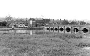
The area south-east of the city was marshy and virtually undeveloped until its draining after the Witham Act of 1812.

This is the first Waterloo Bridge, which was opened in 1817 by the Prince Regent; this view looks from behind Cleopatra's Needle on the north bank. Below are Victoria Embankment Gardens.

The view looks along Bridge Street towards the river. The Original Bakewell Pudding Shop is located further along on the right hand side. Stewarts Clothing Hall is the major building on the right.
This view was taken 70 years after photograph 18642, and apart from the statuary missing from the bridge buttresses, the scene is timeless.

Here we see steamers and pleasure craft on the Thames at Oxford. This photograph was taken from Folly Bridge, which originally had a tower and gatehouse.

We are looking towards Ouse Bridge with South Esplanade on the right.The view has remained virtually the same, except for the difference in the river traffic and a change of use for some of the

We are looking towards Ouse Bridge with South Esplanade on the right.The view has remained virtually the same, except for the difference in the river traffic and a change of use for some of the

This view was taken looking along the backwater from Abingdon Bridge with the gardens of houses in East St Helen Street on the right and a then well-treed Nag's Head Island on the left.

This view, looking west from the present Caversham Bridge past the Reading Rowing Club behind the coach, shows well the flat south bank in contrast to the steep and heavily treed Caversham bank.

This view was taken from Nettlecombe looking towards the thatched Knapp House and St Mary's Parish Church (centre).

The old Roman road drops steeply down onto the green, via a bridge over the short river from Semer Water, two miles away.

This road takes its name from the bridge over the River Colne, visible in the foreground of the picture.

Dell Bridge was built in 1894 to span what was once the upper reaches of Dell Creek, a former tidal creek that once divided the village in half.

This view looks across the River Ise towards the parish church with its graceful 15th-century tower and tall recessed spire.

This was remodelled by Sir Robert Dundas of Loftus Hall, who took a keen personal interest in restoring and developing Loftus.

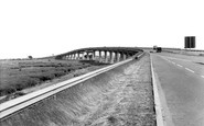
Until the beginning of the 19th century the only crossing of the Hamble was by ferry.The first structure was a toll bridge; today the river is spanned by various busy roads and a motorway—a far

Until the beginning of the 19th century the only crossing of the Hamble was by ferry.The first structure was a toll bridge; today the river is spanned by various busy roads and a motorway—a far

This has its pros and cons: the narrow bridge looks quaint, but it has to take up to 500 coachloads of visitors a year. And there is no car-park.

The River Ashburn rises high on Dartmoor and empties into the River Dart near Buckfastleigh, gurgling through Ashburton as it does so.

The locomotive comes tender first into Newby Bridge station, where it is awaited by the station-master.
Places (17)
Photos (38)
Memories (1928)
Books (0)
Maps (520)

