Merry Christmas & Happy New Year!
Christmas Deliveries: If you placed an order on or before midday on Friday 19th December for Christmas delivery it was despatched before the Royal Mail or Parcel Force deadline and therefore should be received in time for Christmas. Orders placed after midday on Friday 19th December will be delivered in the New Year.
Please Note: Our offices and factory are now closed until Monday 5th January when we will be pleased to deal with any queries that have arisen during the holiday period.
During the holiday our Gift Cards may still be ordered for any last minute orders and will be sent automatically by email direct to your recipient - see here: Gift Cards
Places
26 places found.
Those places high-lighted have photos. All locations may have maps, books and memories.
- Town End, Derbyshire
- Town End, Buckinghamshire
- Town's End, Somerset
- Towns End, Dorset
- Town End, Merseyside
- Town End, Cambridgeshire
- Town's End, Buckinghamshire
- West End Town, Northumberland
- Bolton Town End, Lancashire
- Kearby Town End, Yorkshire
- Town End, Cumbria (near Grange-Over-Sands)
- Town End, Cumbria (near Bowness-On-Windermere)
- Town End, Yorkshire (near Huddersfield)
- Town End, Yorkshire (near Wilberfoss)
- Town End, Cumbria (near Appleby-in-Westmorland)
- Town's End, Dorset (near Melbury Osmond)
- Town's End, Dorset (near Swanage)
- Town End, Cumbria (near Ambleside)
- Town End, Cumbria (near Lakeside)
- Town End, Cumbria (near Kirkby Lonsdale)
- Town End, Cumbria (near Ambleside)
- Town's End, Dorset (near Bere Regis)
- West-end Town, South Glamorgan
- Townend, Derbyshire
- Townend, Strathclyde (near Dumbarton)
- Townend, Staffordshire (near Stone)
Photos
26 photos found. Showing results 3,201 to 26.
Maps
195 maps found.
Books
160 books found. Showing results 3,841 to 3,864.
Memories
3,720 memories found. Showing results 1,601 to 1,610.
Summers In Porch Cottage Luccombe...The Happy House.
Porch Cottage must be called the happy house because as three little girls from a chemical town in the North West we also spent our summers there......of course we are now aged 58, 61 and 63 years ...Read more
A memory of Luccombe in 1958 by
Good Old Feth!
What a joy to read all the memories. I lived in the terrace houses down the side of the Welfare, leaving when I was 12 to live in the new Coal Board estate. All my childhood was spent playing down Green Lane on the pit stacks, ...Read more
A memory of Featherstone in 1950 by
Finchley Road & Frognal Station, Looking East
Having lived from 1938 to 1959 in the adjacent Lymington Road, which backs onto the Richmond-Broad Street Line serving this station and having passed it daily to and from my way to school/work, I ...Read more
A memory of Swiss Cottage in 1950 by
Holidays In Northlew
Re the photo of Northlew Bridge, I am sure this is me, the tallest girl, my sister the smallest girl and the other is my cousin. My grandparents lived in Northlew and we went down from Bolton to visit for holidays.
A memory of Northlew in 1961 by
Drum Roll. Matha Broon Fell Doon
For over thirty years MATHEW BROWN played the BIG BASE DRUM for the local Salvation Army Band. Marching back one morning from an open air service MATHEW slipped on the ice as we marched down a steep hill known as ...Read more
A memory of Kilbirnie in 1970 by
Annie Rowlands Of Stoke Works
I remember staying with my grandmother Annie Rowlands during World War 2 in the village of Stoke Works on Harbors Hill Farm. There was a neighbouring farm there and I remember a John Ford. My grandmother took me on ...Read more
A memory of Bromsgrove in 1947 by
Evacuated To Talsarnau 1940/41
My name is Edward Hughes and at the tender age of 3/4 I was evacuated from my home town of Birkenhead, Wirral, Cheshire to Talsarnau during the second world war; staying around 2 years or so in an allocated home ...Read more
A memory of Talsarnau in 1940 by
Born At Barony Hospital
I was born, illegitimately, in Barony Hospital, Nantwich and lived in Church St, Crewe, moving to Cliffe Road when the "slum" houses were demolished and the police station was built there. I moved from my first school ...Read more
A memory of Crewe in 1954 by
Seaforth Royal Container Dock
I was born in Walton Hospital 1943 and spent a good part of my childhood living in Seaforth. Later in my early 20's moving to Coronation Drive, Crosby. Between 1970 and 71, I worked on the construction of the new ...Read more
A memory of Crosby in 1970 by
Port Regis Catholic School
I never thought I would be commenting on Port Regis. In fact, I have totally forgotten about this place. I could not even remember where it was located. Somehow, the name of Port Regis came into my head tonight and I ...Read more
A memory of Broadstairs in 1960 by
Captions
5,111 captions found. Showing results 3,841 to 3,864.

The name of the town was first recorded in AD 955 as Andeferas. Andover was a municipal borough as long ago as the reign of King John, and later became an established centre for the wool trade.

After the 1850s the new railway from Churston meant that Brixham fish could be sent swiftly to towns and cities throughout Britain.

West Street includes various almshouses and picturesque stone cottages. The Victoria Inn on the left of the picture is now a private house.

Linking the east and west sides of the town over the River Esk, the bridge is now crammed with tourists in the summer months.

This was the parish church in the Earl’s Half; with a floor area of 24,000 sq ft, St Michael’s was one of the most impressive and possibly the largest parish church in England.

Situated east of the town, the total area of the park covers 17 acres. This part is known locally as `the new park`, and it is secluded and peaceful.

This small and delightful riverside town has a bustling quayside with a mix of pleasure boats and commerce in the shape of boat builders and repairers.

On the extreme left is Palmers, with John Bull tyres and cycle lamp batteries on display in the window.

Now very popular because of its proximity to Preston, Longton has burgeoned into a dormitory town with its own medical centre and library.

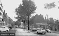
This view was taken looking north along Bridge Street towards the Market Place – indeed, in the left centre of the view we can see the cupola and stair tower of the Town Hall.

The High Street runs parallel to the north wall of the Abbey precinct and has a good range of Georgian and early 19th-century two- and three-storey houses.

The Lynch Walk runs between the deep main channel of the River Lim (left) and the higher-level leat towards Town Mills (right).

Dunstable Street housed most of the 'household' shops in 1955 - the situation has considerably altered since then as the town has expanded its boundaries.

The town is built close to St Osyth's creek, and takes its name from the wife of a 7th-century Essex king. The remains of a superb abbey are to be found close by.

The wooded nature of the river banks is noticeable, and only the industrial scene on the far right of the picture would suggest that this is near the centre of a busy modern industrial town.

As tourism expanded, and smart visitors arrived in ever greater numbers, such untidiness was frowned on by local businesses - the town had to smarten up its image.

Since 1955 two architectural nonentities have appeared on the right of the photograph to mar the already indifferent quality of the market place, and road markings are becoming a prominent feature.

A final view of Epsom town, with its wide High Street and only a little traffic. The clock tower, with public lavatories at its base, was about 100 years old when this picture was taken.

In 1835 Whitty's factory closed, and its machines were sold to a weaver in Wilton. It was not until 1937 that a new carpet factory opened in the town.

Sherborne is, by some people's estimation, the most beautiful of the Dorset towns.

The town centre was constructed on a plateau halfway between Laindon and Vange. The block of 41 shops facing Market Square was the first to be built.

The international aspect of the town's trade can be seen by the sign outside Joseph Hird's grocery in the centre of the picture. It advertises him as a 'French and Italian Warehouseman'.

King's Norton, 'a praty uplandyshe towne', according to the topographer Leland, lies a few miles south of Birmingham, to which city - rather than Worcestershire - it now belongs.

This small seaside town on the west coast overlooks the wide sandy expanse of the Dyfi estuary.
Places (26)
Photos (26)
Memories (3720)
Books (160)
Maps (195)

