Places
17 places found.
Those places high-lighted have photos. All locations may have maps, books and memories.
- Bridge End, Oxfordshire
- Bridge End, Lincolnshire
- Bridge End, Essex
- Bridge End, Bedfordshire
- Bridge End, Clwyd
- Bridge End, Warwickshire
- Bridge End, Surrey
- Bridge End, Durham (near Frosterley)
- Bridge End, Northumberland (near Hexham)
- Bridge End, Hereford & Worcester (near Tirley)
- Bridge End, Hereford & Worcester (near Bosbury)
- Bridge End, Shetland Islands
- Bridge End, Cumbria (near Carlisle)
- Bridge End, Northumberland (near Hexham)
- Bridge End, Devon (near Kingsbridge)
- Bridge End, Devon (near Sidmouth)
- West End, Yorkshire (near Pateley Bridge)
Photos
40 photos found. Showing results 1,041 to 40.
Maps
520 maps found.
Books
2 books found. Showing results 1,249 to 2.
Memories
1,925 memories found. Showing results 521 to 530.
Childhood Memories
I have lived in Mitcham all my life. I was born at St Helier Hospital in 1955 and we lived in the nissan huts opposite what was then Pollards Hill High School in Wide Way, we lived next to a family called the Butlers and I went ...Read more
A memory of Mitcham in 1955 by
Country Memories
I was born at Caroland Close and then moved to Bridge House next to John Childs garage; in those days owned by my grandad, Mathew Ward, where my mother worked in the office. My cousins lived nearby and great fun was had in ...Read more
A memory of Brabourne Lees in 1955 by
High Bridge
When I was very young, just before 1950, I can remember High Bridge was like this without the footbridge beside it. Without so much traffic it was safe to walk over the main bridge. Then the river was tidal and had banks of mud on ...Read more
A memory of Spalding in 1955 by
I Was Eight And Fishing And You Caught Me!
Surprisingly I remember a man setting up the tripod to take this, a short time before I had seen the same process under taken for the school photos. I wondered what he was photographing. I wasn't ...Read more
A memory of Godmanchester in 1955 by
Biography And Memories
I am writing this on behalf of my wife, nee Gena Brown from the old Stirling Castle, otherwise known as the Bottom House, but the one she remembers best is the Staneford Arms where her mother held the licence. Her Auntie ...Read more
A memory of Consett in 1955 by
Park Court ~ Balham Park Road
My Aunt & Uncle (Ella & Cecil Forbes) lived in a two bedroom flat in Park Court in Balham Park Road from 1948 & throughout the 1950s and I spent much time staying with them as my parents ran pubs in The City. ...Read more
A memory of Balham in 1955
Samples Yard
I used to live a few doors from auld Jimmy Sample and his wife Carrie, his son John was married to June and they lived in Francis Terrace. They had their rag and bone yard down the Winnin, anyway I would spend summer nights, weekends ...Read more
A memory of Newburn in 1955 by
The Local Dances And Playing Pool
In the mid 1950s to early 1960s there were local dance halls, one at Newburn which was down Station Road, take a left towards the bridge and it was just there on the left side opposite the level crossings near ...Read more
A memory of Newburn in 1955 by
Holidays
It's just great to look at the old pictures of Blakeney's High Street, it seems almost like yesterday when I used to walk from my gran's house in the row of cottages where the railway bridge used to be. We used to go on ...Read more
A memory of Blakeney in 1955 by
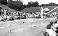
A Pool Of Evocative Tears
I was 8 years old when this picture was taken. It is hard to express how evocative this innocuous little picture is to me. Is that a box of tissues on the right?. Well this picture really set me off blubbing. At this ...Read more
A memory of Barnehurst in 1955 by
Captions
1,770 captions found. Showing results 1,249 to 1,272.

The Shropshire Union Canal, engineered by Thomas Telford and con- structed between 1827 and 1835, was the last of the major canals.

By 1928, the Rustic Bridge seen in photo 40743 had been taken down. The two houses on the left were owned by Spicer Brothers, who owned the paper mill, and were called Orps Mill Cottages.

Perhaps the best-known feature of Burnsall is its magnificent, five-arched stone bridge across the River Wharfe, seen here from the river.

In the background is the ivy-clad nine-arched bridge spanning the Fowey River.

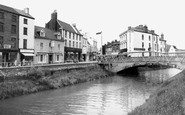
This splendid view of the High Street as it ascends the hill towards the Guildhall was taken from the Town Bridge crossing the River Wey.

Looking down the hill from above the station, we see the bridge carrying the Settle- Carlisle railway line running along the edge of the village.

Thomas Hardy used the Manor at Wool as the setting for the disastrous honeymoon of Tess and Angel Clare in his novel 'Tess of the D'Urbervilles'.

This was designed by John Oldrid Scott, second son of the great Victorian architect, George Gilbert Scott, who built Clifton Hampden's bridge over the Thames further upstream, as well as St Pancras station

Seen from the footbridge to the Oxfordshire bank, the eleven-arch bridge is an 18th-century one that carries a vast amount of traffic, for Sonning is in effect Reading's eastern by-pass.

The corner of Eastgate Street and Bridge Street. The buildings are from the Victorian half-timber revival period, designed by T M Lockwood in 1888. This area of the city is known as The Cross.

A little further downstream, just through the railway bridge, the view down river from the Staines bank has changed; now there is extensive housing development on both banks, much fortunately still hidden

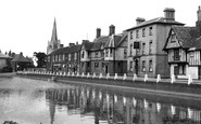
In 1924, this compact little town had (and still has) its own town council.

The Maidstone tramway system opened in 1904, but by 1930 had been replaced by buses and trolleybuses. Maidstone Bridge, which spans the River Medway, lies at the bottom of the hill.

The whole area shown in these two photographs vanished when the new bridge over the river and the new Churchill Road were built to ease congestion in the town centre in 1971.

A fishing boat lies in the tidal section of the canal that linked it to the River Nene, which can be seen under Sluice Bridge.

The river upstream from Kingston Bridge was largely free from commercial traffic, and consequently safer for yachtsmen.

The whole area shown in these two photographs vanished when the new bridge over the river and the new Churchill Road were built to ease congestion in the town centre in 1971.

Note the Malvern Hills in the distance, and the tower of St John's Church, adding interest to this view of Worcester Bridge, which had been substantially widened just a few years before the picture was

With the removal of both the main shopping and administrative areas of Runcorn some miles away these photographs show a town that, in the last 40 years, has changed enormously.

The bridge carries the Padiham road over Sabden Brook into the village.

The view is northwards, towards Chideock, and the mixed herd of cattle - including long-horns - had crossed an ancient packhorse bridge on their way into the hamlet from the eastern pastures.

Ulverston's railway station, dating from 1878, is below the wall to the left - this view was taken from the railway bridge.

This photograph, taken from the east bank of the river, south of the Barley Mow pub, manages to exclude George Gilbert Scott's rather fine 1864 seven-arched brick bridge over the river.

As we look back towards Cookham from near the viewpoint of photograph No 77588 towards the bridge onto Odney, since rebuilt, the Thames is beyond the trees with its two channels.
Places (17)
Photos (40)
Memories (1925)
Books (2)
Maps (520)

