Places
Sorry, no places were found that related to your search.
Photos
Sorry, no photos were found that related to your search.
Maps
Sorry, no maps were found that related to your search.
Books
Sorry, no books were found that related to your search.
Memories
3,644 memories found. Showing results 361 to 370.
Cookridge Once Fields And Farms
I moved from Holbeck in 1948 into one of the first estates to be built in North West Leeds, Ireland Wood (Raynels). In 1950 I went to Cookridge School, then a wooden hut right slap bang opposite where Cookridge ...Read more
A memory of Cookridge in 1950 by
Happy Days
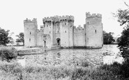
I have many fond memories of Bodiam and the Castle, from when I was 1 year old in 1943, until I was 15. Along with dear Mum and my two sisters, our whole extended family on my mum's side consisting of several families would move to ...Read more
A memory of Bodiam in 1950 by
Stonehurst Five Ashes
We lived at Stone Cottage, and then Stonehurst on the road between Five Ashes and Jarvis Brook for 7 years whilst I was a child. Wonderful freedom absorbing the Wealden countryside. We used the grocers shop, run by Mr ...Read more
A memory of Five Ashes in 1959 by
Wickham Bishops Born And Bred
In 1950 I was born on a cold winter's night to my mother Rosemary Jesse, at 'The Black Houses', Kelvedon Road, Wickham Bishops, built by architect, designer and socio-economic theorist Arthur Heygate Macmurdo. ...Read more
A memory of Wickham Bishops by
Redhill 1961
I remember the Teddy Boys and 'winkle pickers'. Our baby-sitter used to rock and roll in the living room, and us kids used to laugh because we could see her underwear when her flared skirt twirled! She used to paint our nails for us ...Read more
A memory of Redhill in 1961 by
Lamberts Castle
I remember going to Lamberts Castle fair as a small child sometime around 1955. The fair was run by the Herbert family but they stopped running it sometime in the mid 1950s because it was not financially viable. I ...Read more
A memory of Lambert's Castle by
1939 Onwards I Remember
I was born in 1939, the year war started, and remember being lifted out of bed in the middle of the night and the barrage balloons looked like big elephants in the sky. I also remember the table shelter in the lounge which ...Read more
A memory of Harborne in 1940 by
The Capitol Cinema
I remember being taken to the Capitol by my sister to watch the Disney film Bambi. We sat through it three times, I was taken ill the next day and my sister got the blame. The Capitol had a ventilation fan under a hole in the ...Read more
A memory of Barking in 1950 by
My Granddad Stevens
Years ago my grandad had a small garage and workshop at the side of the Du-Cane Arms. My dad was born there and went to scool at Great Tottom. My grandad is buried in Great Braxted Church and my nanna is there too. In the ...Read more
A memory of Great Braxted in 1900 by
St Mark's School In The 1960s
I too have wonderful memories of going to St Mark's, the teachers I remember are Mr Freemantle, Mrs Carmichael, Miss Holmes, Miss Catherine and Mr Legg. The headmistress at the time was Miss Bowley, who everyone was ...Read more
A memory of Mitcham by
Captions
1,151 captions found. Showing results 865 to 888.

This is arguably the most fascinating building in Combe Martin, built in 1690 and Grade II listed.

This photograph was taken at a time when Solva's harbour was reaching the end of its time as a working harbour - the quay with its array of small boats looks somewhat run down.

A place familiar to all train travellers through Devon, Dawlish nestles across the sides of a broad combe, with the railway line protecting the town from the sea.
The entire heart of the town has been moved over the hill to a new site, so that the little that remains of the old High Street is now totally run down.

Going north to the Godstone to Reigate road, that part of the A25 that runs along the greensand ridge south of the North Downs, we reach the village of Bletchingley.

Burgh Heath is very suburban, and its east side is blighted by the roaring traffic of the dual carriageway A217 Reigate road, which merges with the A23 Brighton road at Horley, south of Redhill

Consisting of little more than one long street running east to west, Glanton enjoyed a reputation for the healing properties of the water from the Keppin or Keppie Well situated behind the old school

Although somewhat overshadowed by Pontcysyllte Aqueduct, the beautifully proportioned Chirk Aqueduct ranks as a major work in its own right.

Beyond Crescent Terrace lies the Royal Hotel corner, which is in North Terrace.

Though it passes through an industrial landscape, this canal has many quiet rural stretches where the narrow boats chug along under a dense canopy of green.

The foundation stone of the new Odeon Cinema was laid in 1959 by the actress Lauren Bacall.

Prior to 1582, documents referred to this village as 'Blechingley', meaning 'the ley (or clearing) of the Blaecci people', and its origins probably date back to the 7th or 8th century.
This long straggling village, in the centre of the old tin mining district, sits on a steep hill running down to the Tamar. We are at the bottom of Fore Street looking towards Newbridge Hill.

The boat we saw in photograph M32031R (No 33) is now seen climbing the 5 locks at Tyrley.

By the date this picture was taken, Doncaster had been a racing centre for nearly three hundred years and had been the home of the oldest classic race, the St Leger, since its first running in 1778.

Geese run loose on the grass at Mannington hamlet, midway between the villages of Holt and Horton in the hills north of Wimborne.

Now a tree-clad hilltop fort, this is another example of the many forts built by the Iron Age people. To date it has never been excavated.

Holme is a hamlet on the east bank of the Trent slightly north of Winthorpe. The church was rebuilt in 1485 by John Barton of Calais.

Barnoldswick is pronounced 'Barlick' by the locals. This is another village that has moved with boundary changes.

The vessel approaching the beach, probably on an excursion, is the 'Reindeer', a ferry launched in 1875 as the successor to the 18-ton 'Queen', which had run from 1860.

Coronation Gardens commemorate the crowning of Queen Elizabeth II. The flower beds are a riot of colour in high summer; they lie alongside the stream that runs through the main street.

This is a village of two halves, each bisected by fast-running streams rushing towards the sea. Sandsend was once a centre for alum mining, and remains can still be observed along the coast.

Swain Street runs south from the harbour; it is narrow and mixed architecturally, as can be seen in this Edwardian view.

Burnt Oak will never be at the cutting edge of the tourist industry, but as we look north towards Edgware, we can see that the buildings on the left of this view are of some interest.
Places (0)
Photos (0)
Memories (3644)
Books (0)
Maps (0)

