Merry Christmas & Happy New Year!
Christmas Deliveries: If you placed an order on or before midday on Friday 19th December for Christmas delivery it was despatched before the Royal Mail or Parcel Force deadline and therefore should be received in time for Christmas. Orders placed after midday on Friday 19th December will be delivered in the New Year.
Please Note: Our offices and factory are now closed until Monday 5th January when we will be pleased to deal with any queries that have arisen during the holiday period.
During the holiday our Gift Cards may still be ordered for any last minute orders and will be sent automatically by email direct to your recipient - see here: Gift Cards
Places
Sorry, no places were found that related to your search.
Photos
Sorry, no photos were found that related to your search.
Maps
7,034 maps found.


Books
163 books found. Showing results 7,825 to 7,848.
Memories
22,913 memories found. Showing results 3,261 to 3,270.
Fifty Years Since I Left Crewe
On the 12th of June 1964, I emigrated to New Zealand and sailed aboard the Rangitoto, the voyage took 5 weeks, and called at Curacao, Panama and the beautiful island of Tahiti before arriving in Wellington on the 15th of ...Read more
A memory of Crewe by
Carr Road
I was born in the maisonettes at 191a Carr Road in 1945 and lived there for 20 years until I married my brother is Alan Jackson. I now live in Farnborough Hampshire. My cousin Pat Hodge lived next door as did Ronnie Pickering. Went to all ...Read more
A memory of Northolt by
Carr Road Northolt
I was born 1945 at 191a Carr Road and lived there for 20 years when I married and moved to Hayes. I lived there with my brother Alan, my cousins Roy and Pat Hodge lived next door as well as Ronnie Pickering. Went to all the Wood ...Read more
A memory of Northolt by
Wartime Wycombe
Evacuated here just before the war, I went to Wycombe Preparatory School for six months. I later went to the High School, which was then up Amersham Hill. The School Sports field was at the top of the hill, adjacent to the boys' ...Read more
A memory of High Wycombe by
Fond Memories
My family moved to Bracknell in 1961 from Lancashire. I can remember some of the shops in Crossway. At the top end by the High Street was a toyshop, next door was a gents clothes shop nearly opposite that was Miller Morris and ...Read more
A memory of Bracknell by
A Great Place To Live And Grow Up
Moved up in about 1945/46 into a prefab, our first home., I was about 1 year old so cannot remember the move. I used to help the prisoners of war build the roads, I had a wheelbarrow. We lived at 133 Castle ...Read more
A memory of New Addington by
60's In Hatch End
\yes remember this so well, I live in Pinner now and the modern picture would be full of cars of a day and especially in the evening of people eating out, this must have the most concentrated restaurants in the UK. The only ...Read more
A memory of Hatch End by

Our First Bomb Of The War
Firstly, I must say I was prompted to write this on reading the previous article, I went to school with that writer, Alan Tutt, at Crofton lane School, in 1939 I think it was, or perhaps 1941, anyway we were just starting ...Read more
A memory of Petts Wood by
Northern Drive
hi my name is trevor reece I was born in 1968 my mum and dad lived at 28 northern drive arround the time of the murderd women who livedat 35 god rest her soul.I went to st james school. I remember the park next to polise ...Read more
A memory of Collyhurst by
Big Stars
I saw Little Stevie Wonder at The Orchid when I was about 13 and he not much older, in the early 60s. Amazing young man in his red bolero type jacket and red trousers, playing his mouth organ. Also saw The Drifters there, great group, and ...Read more
A memory of Croydon by
Your search returned a large number of results. Please try to refine your search further.
Captions
9,654 captions found. Showing results 7,825 to 7,848.

It is drained by England's shortest river, the Bain, which runs into Wensleydale at Bainbridge. In this peaceful scene we see two boats tied up waiting for visitors in the shallows of Semer Water.

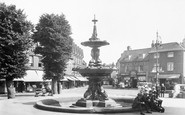
The narrow high street leading to a small square boasted a varied selection of businesses at the turn of the last century.

Until the 1960s, most people relied on public transport, and the green-liveried buses of United Counties carried workers and shoppers in and out of town on busy timetables.

There were two inns in Riverside, the Anchor, still a prominent feature although the front has been reconstructed, and the Anglers, affectionately known to locals as the Annie Miles, the name of the lady

The Lock from Downstream 1890 Downstream, you reach the market town of Abingdon, once noted for its important medieval abbey, dissolved in 1538.

The circle has an attractive setting on a little rise against Castlerigg Fell. To the east there is an outlying stone, over which the sun rises at the spring and autumn equinoxes.

This is a detail of the frontage of 34 West Street, which was the 'Bridport News' office and West Dorset Printing Works in 1909.

Oakfield Corner, built around 1910 and part of the earlier phase of Amersham on the Hill's expansion, chose the vernacular and timber-framed tradition for its shops with flats above.

The town was once under the control of the powerful de Montfort family. At Evesham on 4 August 1265, Simon de Montfort led the barons against the forces of Henry III.

Its replacement, the Railway Hotel that we see here, was built between the wars at the Station Lane junction. The pub became especially well-known for its home-cooked hams.

The amusements are down on the beach, with the old museum ship on the right.

There had been a house (probably half-timbered) at Bank Hall in the Middle Ages, but in about 1780 it was decided to improve the building, and the structure seen in the picture was the result.

Castle Street is 'the finest Georgian street in Cornwall', according to Sir John Betjeman, who knew a thing or two about the county.
Castle Street is 'the finest Georgian street in Cornwall', according to Sir John Betjeman, who knew a thing or two about the county.

Bourne, at the junction where two Roman roads met, had a Roman station to guard the Car Dyke, the great Roman dyke 56 miles long and still surviving for long stretches.

Reaching Spalding we are in the heart of the bulb-growing country; the surrounding countryside is a glorious carpet of daffodils, tulips and other flowers at different times of the year.

Horstead's old mill would have seen many wherries drawn up at its wharf. Coltishall is the gateway to the Broads, set on a low hill above the winding Bure.

Though it passes through an industrial landscape, this canal has many quiet rural stretches where the narrow boats chug along under a dense canopy of green.

The timbered toll-bridge carrying the York road over the Ouse was erected in 1791, and was one of the earliest of its type in the country.

Kendal Castle was built by the Normans to the east of the town, probably by Ivo de Tailbois, the first Lord of Kendal in the late 12th century.

Great Mill is a yellow brick tower windmill standing on a ridge, with panoramic views of the flat fenland.

Although Alfred Waterhouse's Town Hall dominates the scene, it is the small round building almost in the middle of our picture that intrigues me.

The mid 12th-century Great Hall of Robert le Bossu survives in Castle Yard; up to modern times it has been in use as an Assizes Court and Crown Court.

The gardens are on the right of the picture; together with the Imperial Gardens, they testify to Cheltenham's love of flowers. The rotunda (now occupied by a bank) can be seen on the left.
Places (0)
Photos (0)
Memories (22913)
Books (163)
Maps (7034)

