Places
36 places found.
Those places high-lighted have photos. All locations may have maps, books and memories.
- Pentre-cwrt, Dyfed
- Pentre Halkyn, Clwyd
- Pentre, Mid Glamorgan
- Ton Pentre, Mid Glamorgan
- Pentre, Powys (near Llangynog)
- Pentre, Powys (near Guilsfield)
- Pentre, Powys (near Bishop's Castle)
- Pentre, Dyfed (near Pontyates)
- Pentre, Powys (near Newtown)
- Pentre, Clwyd (near Mold)
- Pentre, Clwyd (near Ruabon)
- Pentre, Shropshire (near Chirk)
- Pentre, Clwyd (near Hawarden)
- Pentre, Clwyd (near Chirk)
- Pentre, Clwyd (near Ruthin)
- Pentre, Clwyd (near Mold)
- Pentre, Shropshire (near Oswestry)
- Pentre, Powys (near Welshpool)
- Pentre, Clwyd (near Mold)
- Pentre, Shropshire (near Forton)
- Pentre Broughton, Clwyd
- Pentre Gwynfryn, Gwynedd
- Pentre Maelor, Clwyd
- Pentre-clawdd, Shropshire
- Pentre Galar, Dyfed
- Pentre Llifior, Powys
- Pentre-cefn, Shropshire
- Pentre-Gwenlais, Dyfed
- Pentre-Poeth, Dyfed
- Burntwood Pentre, Clwyd
- Pentre Berw, Gwynedd
- Pentre Hodre, Shropshire
- Pentre Llanrhaeadr, Clwyd
- Pentre-celyn, Clwyd
- Pentre Cilgwyn, Clwyd
- Pentre Morgan, Dyfed
Photos
98 photos found. Showing results 2,141 to 98.
Maps
316 maps found.
Books
2 books found. Showing results 2,569 to 2.
Memories
1,253 memories found. Showing results 1,071 to 1,080.
Growing Up
I moved to Combpyne when I was 4 years old with my mum, dad, brother and sister. We lived in the house in the centre of the village called Clock House. Its garden backed on to the churchyard. I spent many happy hours on the Webbers' farm ...Read more
A memory of Combpyne in 1958 by
Hop Picking
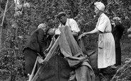
Paddock Wood, in particular Beltring, the home of the famous Whitebread Oasts, was the centre of the Hop Gardens of Kent. The Gardens were set out with rows of elevated wire tressles which were supported at intervals by poles. In ...Read more
A memory of Paddock Wood in 1940 by
My Bus To School From Hatch End To Pinner Grammar School
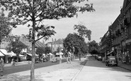
My bus to school, Pinner Grammar, went from this stop in Uxbridge Road in the centre of the picture. It was a red London Transport double-decker route 209 that took us all the way to Cannon ...Read more
A memory of Hatch End in 1956 by
My Childhood
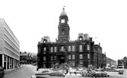
This picture reminds me of the time when a petrol tanker careered down Wakefield Road and crashed into the side entrance of the town hall. This road (pictured) was closed off for a day while the fire brigade dealt with the crash. I can ...Read more
A memory of Dewsbury in 1970 by
Grandfather
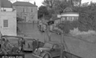
My Grandfather, Reginald Cornish, is standing in front of the car (waiting to embark) in the centre of the photo. He was County Engineer for Monmouthshire. I still live in Chepstow and the buildings to the top and left were demolished after the Severn Bridge was built directly above the slip way.
A memory of Chepstow in 1950 by
No Houses!
This photo shows the street on which we lived around 1948 - but before the houses were built! We lived at 15 Woodcock Road, right across from what was known as Donkey Lane, which was a short cut to the centre of the village and to ...Read more
A memory of Flamborough in 1948 by
John Delves
This is Alan Edgar Fullwood's memory and the reference to Slinfold is right at the bottom of this narration: Edgar Fullwood was my father. He was born in Birmingham England in what is to me the beginning of our history in 1875 on ...Read more
A memory of Slinfold in 1870 by
North Lane
Not so sure of the date, I was born in the cottage hospital in 1936 and spent all my holidays with my grandparents the Brockbanks who had a pub in North Lane called the Heroes of Lucknow. I had many trips to the Lido with my brother, ...Read more
A memory of Aldershot in 1947 by
Rainsford Road
My grandfather owned a music shop in Rainsford Road during the late 1920's and early 30's. It was called Crayfourd's Music Centre. Does anyone have any information on his shop?
A memory of Chelmsford in 1930 by
People, People, People.........
My sister, Helen, and I lived at No. 3 Plasnewydd Street and, although Helen now lives in Lechlade in Gloucestershire and I have finally come to rest (no, not dead - yet) in Cardiff, we talk every week and often reminisce ...Read more
A memory of Maesteg in 1947 by
Captions
3,593 captions found. Showing results 2,569 to 2,592.

The small boatyard on the right is surrounded with corrugated iron-clad buildings, whilst the stone building in the centre proclaims tea gardens on a gable sign, ready for business on this early spring

The turning for Glebe Road is by the double-fronted house in the centre, and the National Provincial Bank was later built on the opposite corner.

An unusual view of the Abbey Gateway—in the centre—and the bridge over the Cornmill Stream, a tributary of the River Lea, with people relaxing around the broken walls.

The fine market cross at the entrance to the Market Place has an elaborate medieval polygonal centre, with three storeys of arched niches; the crocketed pinnacle emerges from a plainer arched

Here in the centre of the village in the market place is a three-sided cross: three arches carry a spirelet, all in mellow golden limestone.

The north-eastern end of Sherborne Lane descends to Lym House and the Angel Inn (centre left).

The windowed building in the centre was lodgings added to the castle around 1690, some of the last new construction on the site.

The founders of the modern Billingham Town Centre felt the need to introduce features which helped to take away the starkness of the new surroundings.

In the 1970s it was re-developed for the Civic Centre, magistrates' courts and police headquarters.

This is a famous town centre view. This clock was originally a project by the Redcar Urban District Council to celebrate the coronation of King Edward VII in 1902.

Beyond it is the former Globe Theatre, and Maxwell's Corner Shop stands in the centre distance.

The sign is on the Red Lion (centre left), which closed in 2000. Opposite is H E Rose, the butcher. The market pump (right) stands outside Wright's newsagents shop.

The Swan, the Town Hall next door and F C Munt, the chemist's (on the corner, left of centre) are unchanged, but the shop between is now Somerfield's.

Next to the thatched cottage in the centre, the houses show a good example of limestone banding in ironstone.

Along with its neighbouring villages of Betteshanger and Tilmanstone, this settlement was a centre of the short-lived Kent coal industry, which began when coal was discovered when borings for a proposed

Behind is Southampton's Civic Centre housing the civic offices, the police station, Southampton lending library and an art gallery. Its tower is 158 ft high.

The Buttercross is to be found in the centre of the village market place. The railings have gone, as have the brick wall and the trees behind it.

However, it was once a more substantial settlement and a significant market centre for the locality.

The 13th-century church of St Mary is on a knoll in the centre of the village. The Lychgate, c1520, is a half-timbered cottage by the churchyard with an upper floor extending above.

The ducks still paddle on the river beside the main road, but the Post Office and Stores (centre) is just a house now.

Beyond is the medieval tower of Skirbeck church, the centre of the village in whose parish medieval Boston was planted: indeed the mighty St Botolph's church was a mere chapel of ease to Skirbeck until

Formerly Garbrand Hall, this two-storied, five-bayed stuccoed house stands at the centre of the village, and was built on a Tudor site around 1775.

The station and crossing is at the bottom of the hill, and next to the Station Tavern (centre right) is now a new signal box.

We are looking south-eastwards from the Yetminster road towards the mediaeval Hamstone cross in a triangle of cobbles (centre), with roads at the junction signed to Sherborne (left) and Chetnole (right
Places (57)
Photos (98)
Memories (1253)
Books (2)
Maps (316)

