Places
Sorry, no places were found that related to your search.
Photos
Sorry, no photos were found that related to your search.
Maps
7,034 maps found.


Books
163 books found. Showing results 2,761 to 2,784.
Memories
22,912 memories found. Showing results 1,151 to 1,160.
Greenford Gardens
We moved to 1 Greenford Gardens in 1936 from Northolt; it was a great place to grow up. Spent most of the time in Ravenor Park playing football/cricket, went to Bethams then Costons Junior with Mr Blount the Headmaster who ...Read more
A memory of Greenford in 1940 by
Patricroft, Liverpool Road.
Just over the bridge at approx 112 Liverpool Rd use to be a grocers shop which Joseph Schofield ran. He was Mayor of Eccles in 1904-06 approx and is my Great Uncle. Also attended the Whit Walks where we walked from ...Read more
A memory of Patricroft by
Hulme Schools And Green Grocers
My girlfriend's mum went to Mulberry Street School in the 1950s and went on to Jackson Street School in Hulme, Manchester, and my grandparents on my mum's side had a green grocers in Moss Side. My ...Read more
A memory of Hulme in 1940
Guildford Area
I remember the castle well, as my family lived in Castle Street, and just after the war, for about two weeks (I'm not sure, but I think it could have been for National savings bonds), the castle was lit at night with a ...Read more
A memory of Guildford in 1940 by
37 Fore Street
My dad's family lived at No 37, Fore Street, Westbury. My grandfathe'rs name was Fredrick Collier.
A memory of Westbury by

Growing Up In The 'ceiber
I have fond memories of growing up in the 'Ceiber'. My family lived on Penrhiwceiber road - the road was full of kids. We constantly played together, roamed over the disused colliery and up the nearby mountain. I ...Read more
A memory of Penrhiwceiber by
Mud And Beer
Although we lived in Ashingdon, my mum used to take me and my siblings swimming at Stambridge Mill. The Cherry Tree pub nearby was where I used to go under-age drinking before I left school. As a very young child I remember visiting ...Read more
A memory of Rochford in 1964 by
St Anne''s
I was baptized, made my first commmunion and was confirmed, at St Anne's Church. I was chosen to be May Queen. I crowned our Lady on May 7, 1961. That same year I went to St. Bede's School in September 1961. I then joined the Handmaids ...Read more
A memory of Ormskirk in 1949 by
The Halcyon 1950's
I lived with my family in Connaught Gardens from being born in 1949 to late 1960 when we moved to Shiremoor. At the end of our street was an overgrown, rubble strewn wasteland which we called 'The Croft'. A natural childrens ...Read more
A memory of Forest Hall in 1950 by
Wallsend 1954 68
Born in the Green Maternity Hosp 1954, lived in Windsor Drive, Howden, Sandown Gardens, Howden and Prospect Ave. I remember being taken to the Masons Arms at Bigges Main in a pushchair, parked outside the corrugated iron lean to ...Read more
A memory of Wallsend by
Your search returned a large number of results. Please try to refine your search further.
Captions
9,654 captions found. Showing results 2,761 to 2,784.

The parish church of All Saints stands on the banks of the River Ouse. Like a watch tower overlooking the river, the tower is embattled and has pinnacles at the corners.

Looking at this beautiful 16th-century thatched cottage, it is not difficult to see what attracted Kenneth Graham, author of The Wind in The Willows, and Dick Francis, ex-jockey and thriller writer, to

Springtime daffodils adorn the bank in front of the battlemented, mostly 15th-century parish church of St Cuthbert at Crayke, a lovely village overlooking the Vale of York.

Southbourne maintains its air of tranquillity even today, compared to the bustle of Bournemouth. It is bordered by the sea on one side and a meandering river on the other.

By the 1950s motor traffic was beginning to dominate the centre of Bournemouth, though it was still possible for drivers to easily pull in at the side of the road.

At Stourport, cargoes were transhipped between Staffs & Worcs narrowboats and Severn trows - these were sailing barges that operated to and from the Bristol Channel ports.

At first glance, this row of modern shops, named after the local Anstey Hall, has not changed since 1960; but closer inspection reveals new tenants in the shops, larger trees and flower beds, and more

The 'Salford City' passes numerous stacks of imported timber at the yard in Station Road, Latchford.

We are standing on the northern shore of the wide and shallow Usk, looking at the grand bridge. It is 17th-century in origin with 13 arches in total, but only 12 are visible from the west.

Camborne's massive Dolcoath mine reached a depth of over 3000 feet. To work it economically many thousands of gallons of water had to be pumped out.

The pleasure of children playing contentedly around their sand castle, on the far side of the river, creates a charming picture often repeated with the passing years.

The rugged nature of the cliffs is typical of the Cornish coastline, where at low water level jagged rocks continue to cause hazards to the unwary mariner.

Thurlestone takes its name from a holed, or thirled, rock just out at sea in Bigbury Bay, which was mentioned in a Saxon charter way back in 845.

The eastern end of Market Place was opened up in the 1830s as the Dewsbury and Gomersal turnpike road.

Constantine's fine terraces are built with granite dug from one of the many quarries nearby, which also furnished the stone for Waterloo Bridge.

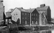
Yet another vanished Surrey watermill, testimony to a virtually forgotten source of power. This mill stood on the Pippbroook, a tributary of the Mole, but has now been demolished.

The view from Constitution Hill across Poole and its harbour remains a tourist attraction today. We can see a tram climbing North Road.

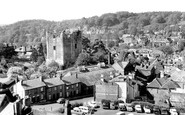
We have an attractive glimpse of the medieval castle keep on its mound, which dominates the roofs of the town and the surrounding countryside.

The men standing at the door on the left are customers of the Lion Inn, which burned down on 8 November 1908 and was never rebuilt. The Congregational Chapel in the background was built in 1831.

As at Clovelly, donkeys were much in use here, ferrying herrings and lime from the kiln (centre) up the hill.

Yachts and motor launches idle in the Yacht Basin under the gaze of the Royal Norfolk and Suffolk Yacht Club, housed in the startling white building at the end of the harbour.

Holiday-makers gather round one of the seaside entertainments. Unfortunately, we have no idea what they were watching, as the Frith cameraman didn't bother to record the details.

Linking the east and west sides of the town over the River Esk, the bridge is now crammed with tourists in the summer months.

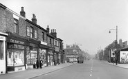
In 1901 the main road to the south was Park Street. The lane to the right leads to Gosmore, and at the top of the hill in front of us, hidden by the bushes, is the Moorhens public house.
Places (0)
Photos (0)
Memories (22912)
Books (163)
Maps (7034)

