Places
Sorry, no places were found that related to your search.
Photos
134 photos found. Showing results 581 to 134.
Maps
896 maps found.


Books
4 books found. Showing results 697 to 4.
Memories
542 memories found. Showing results 291 to 300.
Dunoon Best Holidays Ever
Each year, the excitement mounted as summer drew near. Dad would drag out the large wicker hamper and Mum would start to fill it with clothes, wellies and tins of food from Galbraiths or the Co-op. By school's end, the ...Read more
A memory of Dunoon
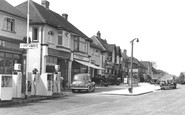
Nork Shops
My Gran lived in the flat above the shop in the photo, next to the garage. Her front door was down the side, and her windows (both open) looked out over shops. The bay window was her living room and her kitchen had the dual aspect windows on ...Read more
A memory of Nork by
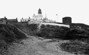
A Broch Childhood
This picture is I would think, the most significant view of Fraserburgh. There are stories surrounding the Wine cave and the Wine tower that all brochers will Know. The entrance to the wine cave is in the corner of this wee bay ...Read more
A memory of Fraserburgh by
Portwood Memories
I have vivid memories of the slippery rock in Vernon Park. Other memories from the park were, the bench in the shelter at the lower entrance, I used to run around on top of the bench. The rhodedendron bushes, they were great for ...Read more
A memory of Stockport by
Newton A Aycliffe In The Sixties
Mu aunt Cecilia Hood lived in Clarence Chare Newton Aycliffe. My Uncle was involved in building the clock in the centre of Newton Aycliffe. My cousin Terence Parnaby and his son Robin also lived in Aycliffe. As ...Read more
A memory of Newton Aycliffe
Medieval Banquets At The Bay Tree
In the early seventies, I was a student at Sarum St Michael College of Education in the Cathedral Close. The weekends were incredibly boring, with nothing to do and nowhere to have fun. Until, a friend asked me if ...Read more
A memory of Salisbury by
The Life Of A .Woolacombe Lad
I was born in the North Devon Royal Infirmary in June 1936 and lived in and around the village for 19 years before doing my national service.I never returned again as i needed a job in a city like Bristol. My father was ...Read more
A memory of Woolacombe by
Fairfield House
I was at Fairfield, late 70s, miss Brooke,was head & she would bounce up drive with tress her Labrador every morning while we were at breakfast,miss coyne became deputy head,& her dogs poppy & berry & that VW She ...Read more
A memory of Broadstairs by
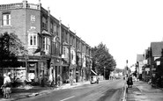
229a Worcester Road/20(?) Merton Road
This picture stirs memories, I stayed in two of the flats above the shops in the 70/80's, & also lived in a house in Merton Road, which is just around the corner from the library - now a betting ...Read more
A memory of Malvern Link by
Thanks For The Memories
Hi I have just read the article "memories of St. Peter's and Broadstairs" by Ronald Taylor, written in 2012. His memories of his childhood in St Peter's could have been mine, I remember everything he mentions including my ...Read more
A memory of Broadstairs
Captions
870 captions found. Showing results 697 to 720.

The railway originally ended at Terminus Place (which is hardly surprising), and housing was laid out along the old lane onto the common: this became Western Road, with Summer Heath Road

The ferry Leatown can be seen tied up alongside the pier, while the Royal Iris waits to dock. The Iris and her sister ship, the Daffodil, entered ferry service in 1906.

This is East Bridge, at the eastern end of East Street (far right), looking eastwards from the north bank of the River Asker.

The High Street is looking remarkably quiet and empty – there are only a few vans and cars, and no road markings.
This is East Bridge, at the eastern end of East Street (far right), looking eastwards from the north bank of the River Asker.

Having accommodated men of the United States 1st Infantry Division before they left Weymouth and Portland to land on Omaha Beach in the D-Day invasion, Freshwater Holiday Camp remains one of the busiest

Close to the road, the solid but impressive ashlar tower dominates the immediate street scene with its substantial angled buttresses and crocketted finials; these are not 15th-century, but were added

This village was once known as Clandon Abbots, for its manor, as in many other Surrey villages, was owned by the local abbey. Here, Chertsey Abbey owned the manor from about 666 AD.

This is the only church in England dedicated to St Cyriac alone – he was a child martyr of the 3rd century.

Situated on the main coast road, this public house is extremely convenient for tourists and the villagers.

We pass under the River Thames via the Blackwall Tunnel - the northbound side dates from the 1890s, an early project of the LCC, which was established in 1888.

Timber from Scandinavia, with a builder's merchant's lorry and cranes, stand on the Quay beside 1864-built Pier Terrace (right).

The post office is on the far left, and immediately next door is A Shenton, dealing in baby linen and ladies' clothes.

In 1842 Port Erin was chosen as the location for a Marine Biological Station; it still exists, though these days it is a part of the University of Liverpool.

This pleasant stone-built Victorian seaside resort, just west of Conwy, clusters beneath the steep craggy slopes of the coastal mountains on Conwy Bay.

This picture of the famous lighthouse on Middle Head was taken from Bracelet Bay.
This ancient port lost much of its importance when the Exeter ship canal was cut in the mid 16th century, causing shipping to bypass its wharves.

Port Talbot's main industries were farming and mining until the early 20th century. Then the steelworks was built, attracting considerable investment.

This view is from the same spot as our last photograph, but roughly ten years later. The narrow road has gone, widened in the name of progress.

A lovely composition of local stone cottages in the lee of the tree-shrouded parish church.

Looking east back downhill from the junction with Bowstridge Lane, the gable on the right is the remnant of a cottage demolished to improve visibility from the lane.

Aberystwyth became a popular resort for the well-to-do, who came here to bathe and socialise from the late 18th century.

Penzance is celebrated as a watering-place on account of its mild climate, which makes it the resort of invalids suffering from pulmonary complaints.

Gourock was among the towns where witch hunts took place during the 17th century. One of the unfortunates who was burnt at the stake was Mary Lamont.
Places (0)
Photos (134)
Memories (542)
Books (4)
Maps (896)

