Places
17 places found.
Those places high-lighted have photos. All locations may have maps, books and memories.
- Bridge End, Oxfordshire
- Bridge End, Lincolnshire
- Bridge End, Essex
- Bridge End, Bedfordshire
- Bridge End, Clwyd
- Bridge End, Warwickshire
- Bridge End, Surrey
- Bridge End, Durham (near Frosterley)
- Bridge End, Northumberland (near Hexham)
- Bridge End, Hereford & Worcester (near Tirley)
- Bridge End, Hereford & Worcester (near Bosbury)
- Bridge End, Shetland Islands
- Bridge End, Cumbria (near Carlisle)
- Bridge End, Northumberland (near Hexham)
- Bridge End, Devon (near Kingsbridge)
- Bridge End, Devon (near Sidmouth)
- West End, Yorkshire (near Pateley Bridge)
Photos
40 photos found. Showing results 921 to 40.
Maps
520 maps found.
Books
2 books found. Showing results 1,105 to 2.
Memories
1,928 memories found. Showing results 461 to 470.
Fig Pudding And A Monkey
I loved Bailiff Bridge - I was there from 1943 (when I was born a Baldwin) to 1961, when I came to college in Hull and settled nearby. I loved my school, with its large shelter in the playground; I loved Miss ...Read more
A memory of Bailiff Bridge in 1949 by
The Wheatsheaf Pub
Crossing the bridge from Woking town into the road where the Wheatsheaf was (and parkland, opposite it) always seemed like going to the posher end of town! It was more classy there with bigger houses surrounding the green! Nice memories!
A memory of Woking
The Old Step Bridge Woking
This memory is very clear to me. As a resident of Horsell I would often walk down Brewery Road to Goldsworth School and over the step bridge, with its iron railings painted green in those days. My brother would take me ...Read more
A memory of Woking in 1957 by
Tideford
This photograph shows Tideford prior to 1961, a quiet village on the road between Trerulefoot and Saltash. That was all about to change when the new Tamar road bridge was opened connecting Saltash with Plymouth in 1961. What had been a ...Read more
A memory of Tideford in 1961 by
Acton Bridge Cruising Club
My memories of Acton Bridge go back to the mid 1950s and early 1960s. The picture of boats at Acton Bridge Cruising Club takes me back to my teenage days. We had a boat called 'Scampi' which was a 32-foot ...Read more
A memory of Acton Bridge in 1957 by
Woodford Bridge And St Paul's Church
I grew up living in Moreton Gardens, my maiden name was Nicholls. I have 2 sisters Pat and Laura. My dear mum used to take us to church every Sunday morning, and I used to sing in the choir. I have some ...Read more
A memory of Woodford Green by
The Dingle
I lived in Colwyn Bay as a child and have fond memories of The Dingle. It seemed like a magical place to a young child. Over the brook, which runs through The Dingle, there was a little bridge which led to a fortune teller's ...Read more
A memory of Colwyn Bay by
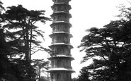
In Line And Two By Two
Miss Cary was short and stout with grey hair in a bun. She always wore a cameo brooch on a white silk blouse, grey skirt and sensible shoes. She was kind and patient, she was also my first teacher. One day as the mothers picked ...Read more
A memory of Kew in 1951 by
My Home Away From Home
I arrived in Totnes January 1944 and lived up at Dartington until a day before the invasion at Normandy. Totnes became our "hometown." I returned for the fiftieth anniversary and honored for being the first American to come ...Read more
A memory of Totnes in 1944 by
Camping Holiday
As a young teenager with fond memories of Evesham and surrounding areas, I enjoyed with two of my male friends, camping at Weir Camping Meadow, which was located by the River Avon down in the lower part of the town. The camping ...Read more
A memory of Evesham in 1940 by
Captions
1,770 captions found. Showing results 1,105 to 1,128.

The park on the south side of the old Dee bridge is known as Edgar's Field in memory of the Saxon king, Edgar.

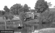
The meeting of the East and West Dart rivers has drawn tourists for as long as transport has been available.

This stretch of the river to the left of the bridge is now Riverside Gardens, but in 1893 it was known as Gunstock Wharf.

The elegant double-span bridge over the River Derwent at Froggatt dates from the 17th century; it is unusual in that it has a large, pointed central arch nearer to the village and a smaller one on the

The last train was on 28 January 1967, and the line is now the Camel Trail, a superb cycleway. The bridge in the picture is just south of Padstow.

The camera is probably on London Bridge, looking downstream across a quieter Pool. To the right is Pickle Herring Quay and Hay's Dock.

This Victorian structure replaced the old bridge. The metal central span was later rebuilt using stone, and until the building of the by-pass in 1974 it carried the heavy traffic of the A30.

Out of sight and beyond the bridge to the left is the new County Hall.

Children and their mothers pose while the men are out at work, fishing or farming. Slate slabs form bridges over the roadside gutters.

This massive medieval structure, formed of flint and ruddy Dutch bricks, squats close by the river, near Bishop Bridge.

By 1904 the quay had gone and larger quantities of heavy goods were being handled on the railway sidings, which had replaced the canal basin.

Here we see the harbour swing bridge, with the important Slate Quay visible on the right. This was connected to the slate mines by a narrow gauge railway.

Here the Rivers Mole and Ember join and enter the Thames. Nearby is Molesey Lock.

Plymouth and Devonport were served by a number of ferries, including these wonderful steam-powered, chain-guided floating bridges on the Torpoint service, which were capable of carrying wheeled vehicles

Further along the bridge we look into the backwater with the lock island on the left and the old lock-keeper's cottage beyond the tree.

This side of Bridge Street in the 1880s and 90s could quite easily have been renamed Ironmongers Row.

Situated about 50 yards below the ferry bridge, the riverside gardens, laid out in 1933, are still well-maintained and attractively stocked.

Bangor's main street runs between the station and the harbour, and today is partly pedestrianised. It is shown here crowded with shoppers and an early car.
Plymouth and Devonport were served by a number of ferries, including these wonderful steam-powered, chain-guided floating bridges on the Torpoint service, which were capable of carrying wheeled vehicles

takes its name from the round stones, or popples (like the pobbles of Budleigh Salterton), that abound in the area; it was a fording place over the Otter for centuries before its stone bridge

It closed in 1974 with the opening of the M5 bridge, which carried a walkway and cycle track along with the motorway. Little commercial traffic now passes through to Bristol.

After crossing the Wye Bridge, our man from Frith captured plenty of activity and detail in this photograph of the main street.

In summer the wooded slopes above are a mass of myrtle and hydrangea. East Looe's cramped main street, edged with a jumble of jettied shops and cottages, tapers down to the quay.

This short, 2-mile canal was opened in 1773, and is an extension of the River Ure. In this view of the stone-walled canal basin we see the cathedral rising over the roofs, and the old arched bridge.
Places (17)
Photos (40)
Memories (1928)
Books (2)
Maps (520)

