Places
26 places found.
Those places high-lighted have photos. All locations may have maps, books and memories.
- Cemmaes Road, Powys
- Six Road Ends, County Down
- Road Weedon, Northamptonshire
- Severn Road Bridge, Gloucestershire
- Roade, Northamptonshire
- Berkeley Road, Gloucestershire
- Harling Road, Norfolk
- Road Green, Devon
- Builth Road, Powys
- Cross Roads, Yorkshire
- Steele Road, Borders
- Cross Roads, Devon
- Four Roads, Dyfed
- Road Green, Norfolk
- Biggar Road, Strathclyde
- Clarbeston Road, Dyfed
- Five Roads, Dyfed
- Eccles Road, Norfolk
- Grampound Road, Cornwall
- Morchard Road, Devon
- Wood Road, Greater Manchester
- Four Roads, Isle of Man
- St Columb Road, Cornwall
- Clipiau, Gwynedd (near Cemmaes Road)
- New Road Side, Yorkshire (near Silsden)
- New Road Side, Yorkshire (near Cleckheaton)
Photos
14,329 photos found. Showing results 961 to 980.


Maps
476 maps found.
Books
5 books found. Showing results 1,153 to 5.
Memories
11,058 memories found. Showing results 481 to 490.
Fondest Memories Of Gt Oakley 1938 To 1961
That was when I was born along with a bunch of other kids who grew up with me and with whom I played during the WW2 years and eventually went to C of E school together. Mr Porter was a teacher there, ...Read more
A memory of Great Oakley by
The Long Walk To Hire A Trike
Millport to me was, as I'm sure it was to most who have visited over the years a place where cars were few and pedal power ruled. All my memories of Millport as a child involved a long walk over the hill from the ferry, ...Read more
A memory of Millport in 1980 by
Scene Of High Street, St. Mary Bourne, Hampshire
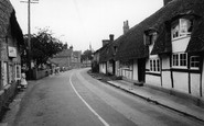
This photograph shows the thatched house of Mr and Mrs Hansford on the right, on the opposite side of the road to the village stores owned by Roy and Ruth Wells. In the centre of the picture, in ...Read more
A memory of St Mary Bourne in 1955 by
Postman Standing On The Corner Of Galgate West With John Street
The Postman is believed to be John Blenkinsop. Five of the entrances to ‘Barney’ have the word ‘gate’ (meaning ‘way’) in their street names. Galgate is the northern way into ...Read more
A memory of Barnard Castle in 1890 by
My Banbury Grans Village
My grandmother's name was Amelia Gough and she lived in the second cottage on the right at the bottom of the green on the road to Mollington. Water was collected by bucket over the road from a tap in the vicarage wall. ...Read more
A memory of Warmington in 1940 by
Victory Parade And The Sudden Downpour
What memories this picture brings back to life again!! I had just been discharged from the Fever Hospital having spent six weeks there with Scarlet Fever. Nothing was going to stop me from taking part in the ...Read more
A memory of Pitsea by
My Family
My father's family moved to Harwich in the early 1900's to cottages below Upper Dovercourt Church and lived there for many years. I was born in 1950 when my parents lived in Ramsey then we moved to Valley Road. I still have family in the ...Read more
A memory of Harwich by
King's Oven
In the 1960s I took my parents to stay in a bungalow a short distance from the Warren House Inn. The bungalow was called The King's Oven, and we rented it for a week. It had been used as accomodation for the tin mine inspector when he ...Read more
A memory of Dartmoor by
Happy Days!
I was born at 1 Woodville Road, Cwm on the 15th November 1940. My Grandfarther was a Miner at the Marine Colliery. His fellow miners called him "Stonejar Morgan" because he took a stonejar full of water to work each day.He was a rescue worker during the "Six Bells" disaster.
A memory of Cwm in 1940 by
Visiting Pontllyfni
I spent two wonderful summers in Pontllyfni in 1974 and 1976. I was a college student from the U.S., visiting Wales with a friend who had a cousin living there. The family owned a small inn just up the road from the beach. ...Read more
A memory of Pontllyfni in 1974 by
Your search returned a large number of results. Please try to refine your search further.
Captions
5,036 captions found. Showing results 1,153 to 1,176.

East Mill stood on the north side of East Road and was powered by the River Asker.

Until the construction of its bypass, most motorists sped through Charmouth on the busy road between Lyme Regis and Bridport, scarcely noticing this charming old village where Charles II hid after the

If the High Street represents remarkable survival, London Road does not. The fine Italianate stucco building of about 1850 on the right survives, and is now Lloyds Bank.

The outbuilding on the right is now The Cat's Whiskers, a hairdresser's whose name wittily puns on the road name.

Despite increases in population and the subsequent rise in road traffic, Herefordshire still manages to retain an aura of peacefulness and serenity, exemplified in this photograph.

This view looks towards Back Road West. (St Ives' streets were often named with commendable simplicity).

The 1898 view shows the earlier type of blinds used by the shops to protect their goods: the awning is supported on wooden posts driven into the road surface.

Westover Road, with its clean-cut and dramatic lines, runs from the direction of the sea to the square; it is still an important shopping street.

It took a number of years to carry out the process of dividing up the land, laying out roads, digging drains, planting thorn hedges, improving the land, and harvesting the crops from more and more

In later years the town became heavily congested with traffic when the Bath Road ran through here.

In the foreground, the road curves to the left round Trinity College. A horse-tram is heading into the city.

The market gardens in the centre are now the Wylie Road housing development. Christ Church was built in 1830-31, high above the town on Sambourne Hill.

Before the A34 ring road, through traffic passed along Northbrook Street - hard to imagine now!
The opposite side of the road from A19709 (above) shows the new frontage of Altham's, now very much a travel firm; the tea sales are a distant memory, although the shop still occupies

For casualties, the Pitsea Health Centre was held at Pitsea School, and was one of just three for Basildon residents of the 1950s; the others were in Craylands, Timberlog Lane, and Florence Road, Laindon

Splendid Georgian buildings line the road. On the right is Agricultural Hall, built in 1882, in more recent years used as the city's main post office, and now as the headquarters of Anglia Television.

This photograph shows Kings Road at the point where it meets Cemetery Junction, to the east of the town.

This aerial view of the Town Centre shows the wide roads threading through the landscape wedges. St Paul's Church was designed to contrast with the building styles of the large buildings around it.

Note the unmetalled surface of the road. The old timbered cottages are now demolished.

The road through the Gap of Dunloe is probably the best-known attraction of Killarney, and starts from the old alehouse, once kept by the infamous Kate Kearney and now named after her.

The road has been widened substantially since this communal water supply was in regular use.

When it was across the road, horses had to drag the boat out to meet the tide.

The banks beside the road show how it has eroded with use over hundreds of years; because of this the houses and small cottages on Church Street have steps down to the pavement.

This view shows the substantial Victorian houses lining Peperharow Road. Note the water tower on the skyline, centre.
Places (26)
Photos (14329)
Memories (11058)
Books (5)
Maps (476)

