Places
12 places found.
Those places high-lighted have photos. All locations may have maps, books and memories.
Photos
191 photos found. Showing results 121 to 140.


Maps
115 maps found.
Books
1 books found. Showing results 145 to 1.
Memories
1,374 memories found. Showing results 61 to 70.
Barry Island In The 50s And 60s
I traveled to Barry Island every summer because it was the nearest seaside to Brynmawr where we lived. The excitement of seeing the sea was overwhelming, and every time I would be sick on the old coach taking us ...Read more
A memory of Barry Island in 1953 by
Wonderful Times
Having spent many happy holidays in Hemsby, my friend Avril and I decided to sign up for a season in Seacroft, we were just 18 and up for what was then an adventure away from home. It was a very happy time, we made many friends with ...Read more
A memory of Hemsby by
East Horsley In The Sixties
I grew up in East Horsley, where I attended St Martin's C of E Primary School. We had no car and we lived nearby so we always walked to the primary school and my mother walked to the shops on Bishopsmeade Parade. When ...Read more
A memory of East Horsley by
Living Opposite The Beach
I was born in Ramsgate in 1953 where we lived for 6 years. We lived in a top floor flat next to the Granville Hotel right opposite the beach. Flat 5, Victoria Mansions, Victoria Parade! Lovely place for early childhood. I ...Read more
A memory of Ramsgate by
Memories Of Hartford
I went to The Little School which was by the crossroads in Hartford. Part of The Grange School. Housed the kindergarten and the 1s. I was there 1964 - 1966. My teachers hers included Mrs Wood, Miss Hatton. The playground ...Read more
A memory of Hartford by
Happiness
Hi in the seventies every summer my late husband, myself and our three children stayed in an old caravan on Plas Hen farm,and they were the happiest of times. We could walk down Lon Geod to go to Afon Wen beach,and a more lovelier walk is ...Read more
A memory of Chwilog by
Happy Days
I, Allen Rix, was born and grew up in Jersey Marine from 1933 to 1951 when I left to join the RAF. Living through World War 2 was hard for a lot of people but for us it was a gat time, even though we had to endure the bombing of ...Read more
A memory of Jersey Marine by
From The Pews Of The Church In Kilinian To Pioneers In Colonial Australia. The Patterson Clan.
The Church at Kilinian during the 18th and 19th century, if not earlier, was a Celtic Presbyterian Church where my ancestors, the Patterson and McClean ...Read more
A memory of Kilninian by
Sun Trap School
I was at sun trap at the age of about 7 or 8 years old .I was. born in 1943 and was sent there after having a very serious. Illness.some happy memories but mostly remembering how hard it was for a small little girl .How hard ...Read more
A memory of Hayling Island by
Lancing, Sussex.
When I was 5, my family moved to Lancing in 1952, from a flat above Elliott's Shoe shop, Brighton Road, Purley (London), to a rented a shared home "Suva" on the Brighton Road, Lancing - a stones throw from the beach. In 1953 we moved ...Read more
A memory of Lancing by
Captions
1,131 captions found. Showing results 145 to 168.

The Island stands at the western end of Porthmeor Beach, visible behind the ruined mine building.

This view shows the beach bungalows which were built right behind the top of the beach. They were used by the military during the Second World War, but are no longer there today.

The beach at Spiddal has always been popular with Galway folk and other tourists. In this scene, the beach is quiet, with bathers enjoying a summer swim. The village is in the distance.

Here we see the post-1953 sea wall, stepped here to allow access to the beach.

Paddling in streams and pools on the beach was popular in Victorian times. Note the hats and long dresses.

The beach is for pleasure too, with beach huts and deck chairs, both offered for hire by W Green and Son. Cromer pier can be seen in the distance.

By this time, Felixstowe was at the height of its popularity as a seaside resort, with its south-facing beach.

This view, with well-clad visitors strolling along the beach and sailing boats drawn up on the shore, shows a south coast beach before development and formalisation changed its character.

Here we have a busy scene, with most of those enjoying the beach placing their deckchairs close to the sea wall. This is a sandy beach, ideal for making sand castles.

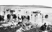
From the bottom of Valley Road the camera captures a crowded South Beach scene, and a bay full of sail-driven fishing boats.

From the bottom of Valley Road the camera captures a crowded South Beach scene, and a bay full of sail-driven fishing boats.

Southsea's long shingle beach crowded with trippers. Not surprisingly, everyone in the picture is fully dressed.

This crowded beach beautifully illustrates the beach fashions of the 1920s: ladies wear summer dresses with straw hats, while the boys and gentlemen retain flat caps, jackets and trousers (rolled up

This panoramic view of Porthminster beach and St Ives was taken from near the local coastguard station. On the left of the picture pilchard boats can be seen drawn up at the top of the beach.

This view shows the beach complete with bathing tents.

The narrow Trebarwith valley emerges at the north Cornish coast; here Trebarwith Strand presents a good beach of golden sand, but all vanishes at high tide.

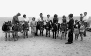
The Beach c1960 With room to spare, this looks as though it was an ideal place to learn the basics of driving before tempting the fates on the open road.

Iron railings have now been erected, with a path from the promenade leading to the beach. As the season got under way, more and more attractions appeared.

The little sea wall on the beach is topped by a fine selection of winches and windlasses, all essential for hauling boats up the beach and clear of storms.

People from Exeter used the sea and sands, the only good bathing beach in the east, back in the early seventeenth century.

Beside Beach Villa with the Metropole just behind, the new cliff lift was in process of being constructed; it was eventually to make access to and from the beach much simpler.

Chesil Beach is a great ridge of shingle eight miles long, with a lagoon of brackish water between it and the mainland.The stones tend to be larger at one end of the beach than the other.

In the days before environmental concerns, both Par Beach and nearby Carlyon Bay were badly polluted by white, sticky clay runoff; as late as the seventies, it was clogging family washing machines after

On the right is the path leading to Friars Point from the beach. Within a few years a beach inspector's/lifeguard's hut, ladies' changing rooms and a small paddling pool would be built near the path.
Places (12)
Photos (191)
Memories (1374)
Books (1)
Maps (115)

