Places
17 places found.
Those places high-lighted have photos. All locations may have maps, books and memories.
- Bridge End, Oxfordshire
- Bridge End, Lincolnshire
- Bridge End, Essex
- Bridge End, Bedfordshire
- Bridge End, Clwyd
- Bridge End, Warwickshire
- Bridge End, Surrey
- Bridge End, Durham (near Frosterley)
- Bridge End, Northumberland (near Hexham)
- Bridge End, Hereford & Worcester (near Tirley)
- Bridge End, Hereford & Worcester (near Bosbury)
- Bridge End, Shetland Islands
- Bridge End, Cumbria (near Carlisle)
- Bridge End, Northumberland (near Hexham)
- Bridge End, Devon (near Kingsbridge)
- Bridge End, Devon (near Sidmouth)
- West End, Yorkshire (near Pateley Bridge)
Photos
40 photos found. Showing results 221 to 40.
Maps
520 maps found.


Books
2 books found. Showing results 265 to 2.
Memories
1,928 memories found. Showing results 111 to 120.
Doseley
When my dad Derick John Jones was born in 1944 he lived in a row of houses called Dill Doll Row or Dill Da Row as some people called them, they were situated at Sandy Bank, Doseley, just behind the Cheshire Cheese pub at Doseley. My dad ...Read more
A memory of Doseley in 1944 by
A Magical Time
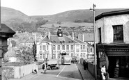
My name is Peter Weeks and I lived on Llanwoanno Road. Every Sunday I would cross this bridge with my elder brother Kenneth, on our way to the Baptist Chapel. This was the time of steam trains. We could hear the trains comming ...Read more
A memory of Mountain Ash in 1964 by
Old Southall Remembered
I lived in old Southall (Norwood Road - Norwood Green end) during the 1960s to the 1990s and have seen great changes. I went to school at Clifton Road, and the school had a great Headmaster, Mr Hancock, for a while. One ...Read more
A memory of Southall
Happy Days
Oh the memories stored away!! Charlie's opposite Cove Green, going there for sweeties on a Sunday, Cove Green (not as good as Tower Hill swings though!), Mundays closing at 1pm on Sundays, Thorntons with its yellow facade, and wool etc, I ...Read more
A memory of Cove in 1965 by
The Pre Fab Years
I was born in Recreation Close - a tiny 1 bedroom maisonette at the bottom of Wide Way. My Grandparents lived in Greenwood Road just around the corner. In June 1944, during the Second World War, a doodle bug exploded on the ...Read more
A memory of Mitcham in 1940 by
Mixed Memories
My family lived in and around South Ockendon for many years. I was born in 1965 in Romford. I went to Shaw County Primary School from aged 4, then to Lennards for years 1 and 2 finally at Culverhouse until I left school in ...Read more
A memory of South Ockendon by
Gladstone Park
Our family moved from Churchill Road, Willesden to the country right out to Dudden Hill, in Normanby Road. The entrance to the park was just down the end of the road near the old iron bridge. There was a rather short ...Read more
A memory of Hendon in 1961 by
My Memories Of Addlestone
Fashion shows with a cup of tea and a biscuit in the Copop on a Saturday. When I was younger the Co-op ran a sports day and we all got a goody box with cream cakes cakes and a suprise of fruit. We shopped at Parrs at ...Read more
A memory of Addlestone by
Happy Days In Latimer
It was only two years or so, from 1959-61, aged 6-8, but it still seems as if the happiest period of my childhood in Latimer was one long, endless, glorious summer. My dad was in the army, in the King's Own Scottish ...Read more
A memory of Latimer in 1959 by
Great Memories Of This Area
Really it was 1961-66. I worked as a Geologist for the United Steel Companies based in Rotherham. I visited Haile Moor and Beckermet Mines every two or three weeks for 5 years and came to love the area and its people ...Read more
A memory of Thornhill in 1961 by
Captions
1,770 captions found. Showing results 265 to 288.

Two little girls slake their thirst at the drinking fountain in the middle of the crossroads leading on the left to Walton Bridge, and on the right to Hersham, Esher and Cobham.
Two of the girls have come down from the bridge and are inspecting the ruined south-west towers.

The River Leven flows through Stokesley, Hutton Rudby and Crathorne before passing under Leven Bridge and joining the River Tees at Yarm.

This view, taken from Lock Island, looks towards the beautiful suspension bridge and the 1832 parish church which replaced the medieval one.

An early traveller from Worcester bound for the Westside would first cross the bridge, then follow a causeway across flood meadows before trudging up narrow, winding Cripplegate to St John's.

At Killin are the dramatic Falls of Dochart, a series of rapids carrying the river under the bridge and through the village.

The transporter bridge and the railway viaduct. In this picture we see the Manchester Ship Canal with the Mersey immediately beyond it.

The Union Canal Bill was approved by Parliament in 1793, and work began in 1794, reaching Fleckney in 1796.

The Arun, described as the second fastest-flowing river in the country, had strong tides; by the 1930s, they reached Pulborough, where two old stone bridges crossed the river.

This is the extremely busy A15 main road heading north to Folkingham, Lincoln and eventually the Humber Bridge and south (the way we are facing) to Market Deeping and Peterborough.
This is the extremely busy A15 main road heading north to Folkingham, Lincoln and eventually the Humber Bridge and south (the way we are facing) to Market Deeping and Peterborough.

Just up river from the bridge and the castle, this would appear to be a view from Wintour`s Leap of the beginning of the great Horseshoe Bend which encompasses the peninsula of Lancaut.

A view of O'Connell Street looking north with O'Connell Bridge over the River Liffey in the foreground.

The village of Waddington has won the 'Best Kept Village in Lancashire' title on many occasions.When Queen Elizabeth II came to the throne in 1953, the village erected a Coronation Bridge and laid

Within fifteen years of this photo, the roadway had been made into a proper bridge, and there had been an infilling of bungalows on the left- hand side.
Two of the girls have come down from the bridge and are inspecting the ruined south-west towers.

With its five arches, this ragstone bridge over the River Medway is said to be the finest medieval bridge in the south of England.

was constructed along the south side of the Rheidol in 1901 to transport lead ore from the mines to the harbour, but it became a very popular tourist attraction for those wishing to visit the Devil's Bridge and

As we look at this mundane street as it drops down towards Pinner Underground Station, under the railway bridge and on towards Harrow-on-the-Hill, there is little to herald the wonderful surprise of turning

The bridge was opened by Princess Alexandra on 21 July 1961. More than 5,000 tons of steel was used in its construction.

This wonderful view from the walls was taken before the onslaught of the motor car, and when gas lamps were still in place.

A summer picture showing an image that characterises Bedford in the middle of the 20th century as bridge, river and church link under a summer sky.

A view from the west bank of the River Medway, looking to the medieval bridge and Aylesford. It is superbly proportioned, with one wide central span and three smaller arches on the approach.

Five miles south-west of Bridgend, this crenellated mansion was built on the site of a former medieval fortress for Thomas Wyndham MP between 1802 and 1806.
Places (17)
Photos (40)
Memories (1928)
Books (2)
Maps (520)

