Places
17 places found.
Those places high-lighted have photos. All locations may have maps, books and memories.
- Bridge End, Oxfordshire
- Bridge End, Lincolnshire
- Bridge End, Essex
- Bridge End, Bedfordshire
- Bridge End, Clwyd
- Bridge End, Warwickshire
- Bridge End, Surrey
- Bridge End, Durham (near Frosterley)
- Bridge End, Northumberland (near Hexham)
- Bridge End, Hereford & Worcester (near Tirley)
- Bridge End, Hereford & Worcester (near Bosbury)
- Bridge End, Shetland Islands
- Bridge End, Cumbria (near Carlisle)
- Bridge End, Northumberland (near Hexham)
- Bridge End, Devon (near Kingsbridge)
- Bridge End, Devon (near Sidmouth)
- West End, Yorkshire (near Pateley Bridge)
Photos
40 photos found. Showing results 1,001 to 40.
Maps
520 maps found.
Books
2 books found. Showing results 1,201 to 2.
Memories
1,925 memories found. Showing results 501 to 510.
Near ''the Lammas
1954-1959, say?? Perhaps earlier too. This section of the River looks v. close to the area off the top of Thames or Bridge Street (?) known as The Staines "Lammas". A number of pools and play areas, with a swimming pool set into ...Read more
A memory of Staines in 1956 by
183 Bus To The Pinner Red Lion
All buses going to Pinner in the 1950's had the destination "Pinner Red Lion" as there was an old pub of that name on the corner of Love Lane and Bridge Street. The bus in this photo has continued its journey having ...Read more
A memory of Pinner in 1956 by
Mytchett Post Office
My family moved to the post office in Mytchett Road in 1956 when I was six. I used to catch the bus at the bus stop opposite to go to Ash Vale Primary School. Yes, on my own, clutching my penny ha'penny bus fare and reciting ...Read more
A memory of Mytchett in 1956 by
Childhood Memories
I was born in 1951 and lived in Middlefield Road, Mistley with my parents, sister and brother. My maiden name was Lay - Flurrie. I attended Mistley Norman School in 1956 my teacher being Miss Temple, Headmaster was Mr Thompson. ...Read more
A memory of Mistley in 1956 by
Black Bridge
When we were down in Pembrokeshire we sometimes walked back from Hakin Primary School to Hazelbeach and Black Bridge was a landmark on the way. I remember the rotting hulks of the old barges in the Pill and the transformation of ...Read more
A memory of Milford Haven in 1956 by
Fullerton Road & Area 1956 65
I lived at 2 Fullerton Road from 1956-1965, it was a cul-de-sac in those days. It was lined with Plain Trees with sticky leaves. There were a couple of factories at the end on the left hand side, the names fail me ...Read more
A memory of Addiscombe in 1956 by
School Days
As a girl i lived in Ruislip, but, having passed the 11+, went to Notting Hill and Ealing high school, travelling by bus every day. The school was in Cleveland Road, from the art room you could look over the wall of St Davids home and ...Read more
A memory of Ealing in 1956 by
Garetts
I was born in Woolwich in 1948. The things I remember of the shops in Powis St; David Greggs was where my mother would send me for ham off the bone, I also remember Biddles Fruit and Veg which was just off the High St. The R.A.C.S. ...Read more
A memory of Woolwich in 1956 by
Pinner Village In The 1950's
This is the Pinner village scene as I remember it from my schooldays. The photographer is standing close to the junction of Chapel Lane and Bridge Street looking up the hill towards the Langham Cinema. Chapel Lane on ...Read more
A memory of Pinner in 1956 by

Coronation Park
I remember this area before it became a park (for the blind?). If I was feeling adventurous I would cross the little stream that ran at the bottom where the gardens are now, sometimes there was a makeshift bridge across it. I used ...Read more
A memory of Corby in 1956 by
Captions
1,770 captions found. Showing results 1,201 to 1,224.

Motorcycles with sidecars were a popular and economical means of getting about for ordinary people.

Aylesford is a perfectly sited village by the River Medway and the scene of many battles in ancient times.

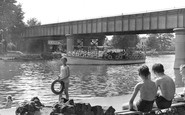
Upstream from the lock at Sonning, the 18th-century bridge spans the river, and the recreational use of the water is plain to see.

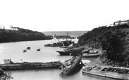
Brunel used Neyland as a terminus to connect to Ireland and the Atlantic, and his imprint remains everywhere, such as the name Brunel Avenue.

We are looking from the Nag's Head Island side towards Bridge Street and the town.

Full of quaint old Georgian houses and historic buildings, Arundel has long been an obvious destination for tourists and visitors.

This view looks south from the bridge over the River Medway. The lofty tower of the 14th-century All Saints church rises behind the Archbishop's Manor House and grounds.

The Wye River is viewed here looking downstream from the Kerne Bridge. Within a short distance, the river becomes the border between Herefordshire and Gloucestershire.

Full of quaint old Georgian houses and historic buildings, Arundel has long been an obvious destination for tourists and visitors.

Across the toll bridge from Batheaston, the road crosses the A4 dual carriageway Batheaston bypass into Bathampton, a village now linked by development to Bathwick and Bath.

The area south-east of the city was marshy and virtually undeveloped until its draining after the Witham Act of 1812.

Here were clipped green lawns and exquisite quadrangles.The fortunate few could enjoy a few precious moments away from the bustle of the city streets above.

Here, at Belmont Hill, we are looking out of the village, towards the former toll bridge over Wicken Water.

The only real change to this scene is that now there are no cars - the whole of Bridge Street up to Cathedral Square has been closed to traffic and paved over.

The meeting of the rivers with their tiny bridges adds to the charm of the village and its thatched cottages. In the foreground are Closewool sheep, typical of Exmoor.

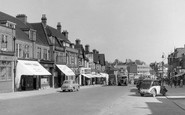
Bridge Street was clearly Warrington's shopping centre in the 1950s. The west side offered some of Warrington's finest shops.

The first structure was a toll bridge; today the river is spanned by various busy roads and a motorway - a far cry from the days centuries ago when this river and many others like it on the south coast

The Bere Stream, seen looking eastwards from Southbrook Bridge, towards Bedford and Jesty's watercress beds with a glimpse of Woodbury Hill (top left).

Often referred to by locals as the 'Flower Gardens' here is the same scene some 35 years after that shown in 38714 (above) and a new concrete bridge is in place.

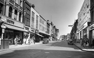
This section of Bridge Street has changed drastically since this view towards Market Gate was taken.

The £8 million suspension bridge was opened by Queen Elizabeth II in September 1966 to carry the new M4 motorway from England across the Severn Estuary to South Wales.

Motorists speeding through Duffield on the A6 miss this view of the fine buttressed bridge across the River Ecclesbourne.

She had a wooden clinker- built hull and was powered by a grasshopper engine. Her steering position was on the main deck foreword of the bridge.

Bridge Street was one of four main streets intersecting at Market Gate. All were not only shopping streets, but a key part of the regional road network.
Places (17)
Photos (40)
Memories (1925)
Books (2)
Maps (520)

