Places
7 places found.
Those places high-lighted have photos. All locations may have maps, books and memories.
Photos
56 photos found. Showing results 121 to 56.
Maps
55 maps found.
Books
Sorry, no books were found that related to your search.
Memories
646 memories found. Showing results 61 to 70.
Bombing Raids In 1940
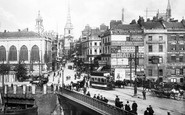
Bristol's premier shopping centre was turned into a wasteland of burned out buildings after major bombing raids in 1940, during the Second World War. Bridge Street Summary Bridge Street ran from High Street, rising up a ...Read more
A memory of Bristol by
Wonderful Memories Growing Up In Bassaleg
I lived in Bassaleg from the age of 3, (1955), when Church Crescent and surrounding area was being developed. I lived in Church Crescent with my family until I left for Manchester in 1976. I went to the ...Read more
A memory of Bassaleg in 1966 by
Early Years In Hindley
What - no memories of Hindley? I was born in 1935 (nee Pennington) at a house in Liverpool Road, just up from the Strangeways Pub (The Paddock). The area was called Navvies' Lump, and although the address was "Liverpool ...Read more
A memory of Hindley in 1930 by
Those Were The Days!
I was at secretarial college in Folkestone in the mid sixties and "The Old High Street" was my stamping ground, along with "Tofts". I remember Archie and Andy who owned the Acropolis at the top on the left and of course ...Read more
A memory of Folkestone by
1950s
I was born in the war years in the area where the Workmen’s Club was later built and later moved to Hall Lane Est ( 28) as the first intake. I remember well the coal loader at the end of Railway Terrace and the great times out and about around ...Read more
A memory of Crook by
Happy Days
Oh the memories stored away!! Charlie's opposite Cove Green, going there for sweeties on a Sunday, Cove Green (not as good as Tower Hill swings though!), Mundays closing at 1pm on Sundays, Thorntons with its yellow facade, and wool etc, I ...Read more
A memory of Cove in 1965 by
The Pre Fab Years
I was born in Recreation Close - a tiny 1 bedroom maisonette at the bottom of Wide Way. My Grandparents lived in Greenwood Road just around the corner. In June 1944, during the Second World War, a doodle bug exploded on the ...Read more
A memory of Mitcham in 1940 by
Happy Days In Latimer
It was only two years or so, from 1959-61, aged 6-8, but it still seems as if the happiest period of my childhood in Latimer was one long, endless, glorious summer. My dad was in the army, in the King's Own Scottish ...Read more
A memory of Latimer in 1959 by
The Bathing Hole
The stream in front of the war memorial ran down to the Browney river a few hundred yards below the Dean, where half of the Witton school kids learned to swim in deep pools created by dams made by Harry Bell and Davy ...Read more
A memory of Witton Gilbert in 1954 by
Birthplace And Never Forgotten When Asked
I was born in Dysart to a mining family of 5 brothers, me being in the middle. My mum watched over us all and used to take us walks by the man in the rock along to Wemyss and back via the castle estate. ...Read more
A memory of Dysart by
Captions
334 captions found. Showing results 145 to 168.

The view is northwards, towards Chideock, and the mixed herd of cattle - including long-horns - had crossed an ancient packhorse bridge on their way into the hamlet from the eastern pastures.

She was 80 feet long and 11 feet 6 inches in the beam, and was launched at Newby Bridge in 1843. Lady was paddle-driven – this was necessary because of the shallow river waters.

Wilburton lies on the Haddenham ridge of the Isle of Ely. The medieval route from the Aldreth crossing to Ely went along the High Street.

The broad channel between Drake's Island and Mount Edgecumbe, known as The Bridges, is only navigable via one narrow channel, which is why ships always appear to take 'the long way round', following

The humbler quarter of town is on the east side of the bridge over the Fowey, where the old road climbs out towards Liskeard.

The bridge is more than over 2,760 yards long, including the approach viaducts, giving a clear headway at high water of 150 ft. The steel towers stand 360 ft high and are supported on granite piers.

A radically transformed settlement now, with the bridge long rebuilt, Bathpool is just off the modern road built to link the town with the M5's Junction 25.

John Wing's 1811 bridge replaced a medieval one built or rebuilt soon after 1224; the builders probably used stone from the demolished castle, which was destroyed or 'slighted' after a punishing siege

When the new Worcester Bridge opened in 1781 it gave Broad Street quite a boost, helping it to support three coaching inns.

Once the canals ceased to be used for the transport of goods, it did not take long for them to become silted up and overgrown. Notice the route of the towpath going over the bridge.

The Square lies at the north end of the Long Bridge. The building to the right is the red façade of The Athenaeum, built in 1888, which houses the museum and a collection of fossils.
The river near the new bridge now has rows of wooden houseboats moored along the right bank, where Wayford Farm has been developed into the Wayford Bridge Hotel.

Just beyond the 201ft-long lock, the Thames is now spanned by the bridge carrying the M3 motorway out of London, and this peaceful scene is now augmented by the constant susurration of traffic noise.

This is a fascinating photograph, because it shows both the railway bridge (built in 1868; it even had a pedestrian walkway along it) and the transporter bridge in front.

Winter skaters used to risk their lives on the thin ice, and fishing from the bridge has long been a popular activity here.

Beside the stone causeway and bridge, rowing boats invite anglers or sightseers to venture out on the water.

The river flowing beneath the 15th-century bridge is the Darent, which rises near the county boundary with Surrey near Westerham and runs through a myriad of Kent villages to the Thames near Long-reach

We end this chapter in St Peter Street, which originally led to the old wooden bridge replaced by the present one further west.

This view of the River Tove is taken from the bridge that crosses the river on the line the Romans set for Watling Street, where the road itself changes alignment from north-west to west-north-west.

Full of quaint old Georgian houses and historic buildings, Arundel has long been an obvious destination for tourists and visitors.

This view looks south-westwards from Broad Ledge to Long Ledge (foreground) below Gun Cliff to the Guildhall (top right), the Fossil Depot beside Buddle Bridge and the Assembly Rooms (centre), with the

We are looking from the Nag's Head Island side towards Bridge Street and the town.

Full of quaint old Georgian houses and historic buildings, Arundel has long been an obvious destination for tourists and visitors.

The little hamlet of Brockweir, straggling along the floor of the Wye Valley and with a utilitarian bridge spanning the river itself, lies on the county border with Gwent.
Places (7)
Photos (56)
Memories (646)
Books (0)
Maps (55)

