

Places
Sorry, no places were found that related to your search.
Photos
Sorry, no photos were found that related to your search.
Maps
Sorry, no maps were found that related to your search.
Books
Sorry, no books were found that related to your search.
Memories
3,645 memories found. Showing results 441 to 450.
Almondsbury South Gloucester
Where do I start ? Living in Monmouth House on the top of Almondsbury Hill. going to Almondsbury village school sitting next to Tony Evans, head of the Patchway gang & a brilliant football goalkeeper. Gaffer ...Read more
A memory of Almondsbury in 1940 by
Wwii Billet
My mother, Maude Doyle was billeted at a farm in Outwell while stationed at searchlight battery at Sutton Bridge that served as RAF base. Fighter aircraft used the gun butts there to adjust their cone of fire I understand. The farmer's ...Read more
A memory of Outwell in 1940 by
A Wonderful Childhood At St Catherines
My late father, Rev H Roderick Carter, was the Vicar at St Catherines from the early 1950's to about 1968. Living at the Vicarage meant that we had people coming and going all day, everyday. Mum was very ...Read more
A memory of Norwich in 1955 by

Brothers And Sisters
My brother Christopher and I first went down to school at Visitation Convent, Bridport in September 1957. We lived in Ascot as our father had been an officer in the Royal Horse Guards and had been based at Windsor. We took a ...Read more
A memory of Bridport by
St Marys Home
My memories of the home, which was run by the Southwark Catholic Rescue Society. The sisters of charity looked after us, I was taken there just before my 10th birthday in april 1947 along with brothers Bill 13 and Bob 4. My early ...Read more
A memory of Gravesend in 1947 by
Working In Clyffe Pypard
I came down from Scotland when I was 16 & was a nanny in Broad Hinton for a year for Mr & Mrs Huddy (can't remember the name of the house), & then I decided that I wanted to work with horses, so I got a job ...Read more
A memory of Clyffe Pypard in 1969 by
The Mc Ateer Family
Just a test run from John Mc Ateer. My brothers Patrick and George are still with us, Pat is still in the UK and George and I are very happy here in Australia. Best wishes to all old friends who share WW2 memories with us. Hayes is now a happy haze!
A memory of Hayes in 1940 by
St. Oswalds Girls School
I came to Alllerwash Hall, Fourstones, when it was a private girls' boarding school called St.Oswalds. The Second World War had ended that summer and my mother had died just before Xmas that year, I was eleven. I had had a ...Read more
A memory of Allerwash in 1945 by
Off Licence
My mum used to run the off licence...she started working there the year my older sister turned 11 and passed her 11+. My mum ran the off licence until she had to leave in 1979 when my dad had his first heart attack. Dad is still alive ...Read more
A memory of Stanwell in 1966 by
Laleham Ghost
I was sitting on the riverbank seat at the end of Blacksmiths Lane with another girl and three boys, we were laughing and chatting one summer evening at about 8pm. Suddenly and simultaneously, we saw a hooded monk like figure dressed in ...Read more
A memory of Laleham in 1962 by
Captions
1,151 captions found. Showing results 1,057 to 1,080.

The beacon on Pendle Hill is said to be Saxon, and the field known as Kirkacre was in existence when Alfred the Saxon was chieftain.

The Devil’s Arrows is nowadays composed of three stones. They stand in North Yorkshire, close to the A1: it is one of the most famous prehistoric monuments in the county.

The attention of the children and the men is attracted momentarily from the movements of ships and the sea by the novelty of a camera.

The WB&SSPCo paddler 'Victoria' disembarks trippers on to the steep-shelved beach in Lulworth Cove.

The shop on the left is Jarman's the photographers. It was designed by William Spanton in 1863 for his 'Repository of the Arts' and was owned by Harry and Oswald Jarman from 1901 to 1962.

The turnpike road through Charmouth was run by the Bridport District Trust from 1764 to 1877. For several decades in the next century it carried the A35 Folkestone to Honiton trunk road.

The road running through the village is the A59 from Clitheroe to Skipton. Note the New Inn on the left of the picture, and how large the name-board of the publican was.

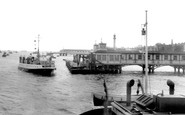
Passengers on a Douglas boat take in the sights, sounds and smells of Belfast Harbour.

Running at right angles to each other, Eastham Rake and Bridle Road link at the junction with Stanley Lane and the A41 - New Chester Road.

Around AD 120, a mansio was built on a slight rise overlooking the site of the fort.

Most of the coastal trading vessels working out of Padstow were schooners or ketches, and many earned their keep beach trading.

The conglomeration of boats assembled closely within the harbour are under the supervision of two men, one on the far left, the other on the right.

THE only safe anchorage on the inhospitable, craggy coastline between Appledore and Boscastle, Clovelly lived precariously for centuries from the herring fishery.

Previously a corn mill, the building was converted to manufacture hand-made paper in 1713.

Shops here have been kept by the same families for years, and they still have a reputation for quality and service.

The Icknield Way was a pre-Roman, Iron Age trading route running along the northern border of Hertfordshire. At Baldock it formed the length of White Horse Street and Hitchin Street.

In the shallow recess stands a pump which was used by the boys to collect their washing water until washrooms and indoor toilets were installed in 1922.

In the shallow recess stands a pump which was used by the boys to collect their washing water until washrooms and indoor toilets were installed in 1922.

During the 17th century, smuggling around the coast of Britain became a highly lucrative trade, and could be just as vicious as it sometimes is today.

The White Swan public house, first mentioned in 1722, stands on raised ground just beyond the beached punts to the left of centre.

Holywell developed by the Great Ouse as a traditional `ring` village: the main street runs around the perimeter of the community with only one access road.

Whalley means 'the clearing or field by the hill', and we can see how close the hill, known as Whalley Nab, is from our photograph.

In 1792, a company was formed by Lancaster merchants; they saw a canal as a way of getting cheap coal from Wigan and getting other goods out to the towns in the heart of Lancashire, and to the growing

This was dubbed at the time 'the largest room in the world'. It was 4,405 square yards in area, and 96ft high and 125ft high to the top of the central dome.
Places (0)
Photos (0)
Memories (3645)
Books (0)
Maps (0)

