Places
18 places found.
Those places high-lighted have photos. All locations may have maps, books and memories.
- Hythe, Kent
- Hythe, Hampshire
- Small Hythe, Kent
- Bablock Hythe, Oxfordshire
- Methwold Hythe, Norfolk
- Hythe, Somerset
- Hythe, Surrey
- Hythe End, Berkshire
- The Hythe, Essex
- Egham Hythe, Surrey
- West Hythe, Kent
- New Hythe, Kent
- Broad Street, Kent (near Hythe)
- Horn Street, Kent (near Hythe)
- Newbarn, Kent (near Hythe)
- Newington, Kent (near Hythe)
- Broad Street, Kent (near Hythe)
- Stone Hill, Kent (near Hythe)
Photos
360 photos found. Showing results 1,021 to 360.
Maps
101 maps found.
Books
10 books found. Showing results 1,225 to 10.
Memories
4,406 memories found. Showing results 511 to 520.
Early Memories
My birth on 30 Nov 1946 at 34 Oldberry Road, Burnt Oak, is where it all started for me, but my mother & her parents moved into the house when it was built for the LCC. She's 89 now, but recalls that she, as a 9-yr-old in 1928, ...Read more
A memory of Burnt Oak in 1946 by
Doe Lea In Ww2
I arrived in Doe Lea in June 1940 with other evacuees from Lowestoft, Suffolk. I lived in Doe Lea untill 1944. At first we were not accepted by the local children, eventually we mingled and became friends, since the war have been ...Read more
A memory of Doe Lea in 1940 by
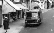
Hednesford
The picture of the Van in the main street of Hednesford is I think the Co-op grocery delivery van. Just below the woman was then a Co-op grocery store. The van was driven by a man by the name of Tommy; I unfortunately can't remember ...Read more
A memory of Hednesford in 1960 by
No 10
My name's David Meacham - When I was very small I used to live in the cottage on the right - Number 10 Bremhill. It was a wonderful place to be a child - few cars then of course - and the freedom to roam the village without any fear. The ...Read more
A memory of Bremhill in 1962 by
Ann & Vic Norman's Shop
My mother Joyce Stannard worked at the shop in this picture in the foreground with the canopy next to the wine merchants. When she started it was a little wool shop owned by Miss Wright - she sold it to the Norman's who ...Read more
A memory of Cobham in 1960 by
Snowing And Floating
Can't be too specific about the year, just know I was young. Perhaps we'd not been long in our house on Carr Lane, having lived in Dronfield before. What a treasure this house was, running water, separate bedrooms ...Read more
A memory of Dronfield Woodhouse in 1956 by
Goldthorpe In The Fifties
I was born in 1946 and lived in Manor Avenue. Cricket with dustbin lids propped up with a house brick in the "backins" were our stumps and we played from dawn to dusk during the summer holidays...except during Wimbledon ...Read more
A memory of Goldthorpe by
Married Quarters Inkerman Road
My dad was a military policeman stationed at Inkerman Barracks and we lived at No. 1 MSQ Inkerman Road. It was great fun there, the woods over the road, next to the Victoria Cafe (all now gone). To the side of No. 1 ...Read more
A memory of Knaphill in 1959 by
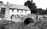
Happy Days At Mill Bridge
Hi to anyone looking at this photo, I lived just up the road at Valley Cottages and used to play by the bridge, we all sat on the bridge wall and had our photograph taken. I am on the right with wellington boots ...Read more
A memory of Bishop's Tawton in 1955 by
Ffynnongroyw
I read with interest the account of Ken Davies and his childhood memories of the Garth Mill in Ffynnongroyw. We moved to Llinegr Farm on October 2nd 1961 (I was 7) and moved on November 6th 1988 after my father's death. I remember ...Read more
A memory of Ffynnongroyw in 1961 by
Captions
4,899 captions found. Showing results 1,225 to 1,248.

Today, its past is commemorated by the Whitbread Hop Farm, the largest hop and oast complex ever built, and now a popular museum.

By the end of the century the figure was one in five.

Camping was a popular, cheap way of spending a family holiday by the sea. The tent in the foreground has a large awning, a useful way of extending the living area.

Portchester Castle was built by the Romans to defend the English Channel from raiding Saxons and is one of the largest of the 'Saxon shore' forts.

It looks southwards towards the Garth and Bangor, which is backed by the Snowdon mountains.

Its size indicates the relative wealth of this small country town well into the 20th century - its fortunes boosted by the presence of adjacent military camps.

Above the entrance is a gallery, and it was from here that a parson, ejected from the church by the Commonwealth, used to preach to the villagers. The house later became a bank.

The falls are caused by the waters of the Dungeon Ghyll, which rises on the Langdale Pikes above, and crashes through this tiny gorge of sheer-sided rocks.

Various figures can be seen seated by the 40-ft Cross, which rises from seven steps at the point where three roads meet.

One problem not foreseen by the planners was the dramatic increase in car ownership. The initial blueprint allowed for one garage for every six homes.

The station served the Midland Railway, and its Euston Road frontage is still dominated by the Midland Grand Hotel designed by Sir George Gilbert Scott.

Bishops Walk, the quiet riverside path, was shortly to be replaced by the main road to be known as Lambeth Palace Road and the Albert Embankment.

Ordnance Survey maps show that it was built on the site of an older road, New Barn Road, whose path had run across the present road, but which was blocked by the railway of 1903.

At this date it is still surrounded by the countryside, and woodland dominates the skyline. Up the hill to the left is the Workhouse, with the Trenance flour mill and its chimney below.

The medieval cathedral had been destroyed by the armies of Henry III and Edward I, and the present building was rebuilt after it was partially destroyed by Owain Glyndwr in 1402.

The Cross is dominated by the tower of St Nicholas's Church - said to have been originally designed for St Martin's- in-the-Fields in London.

By the rules of the foundation, for eight centuries travellers have been given bread and ale on demand—the Wayfarers Dole.

At this date, holiday makers could still arrive by the railway as well as by road.
Above the entrance is a gallery and it was from here that a parson, ejected from the church by the Commonwealth, used to preach to the villagers. The house later became a bank.

It was originally called Bartholomew's Gate, but was changed by order of Charles II who landed here in 1683, accompanied by the Duke of York, on his way to London.

A small girl waits by the picket fence, and women watch the boy delivering a sack of coal on a trolley -the photographer has asked them to pose.

This charming view is enhanced by the irregularity of the steps. It shows how elevated the church is, facing countryside to the south but opening out onto the Market Place to the north.

This decision, however, was overruled by the local curate.

The building that was originally the Railway Tavern is hidden by the tall tree on the right. Its mock-Tudor successor can be seen to the left.
Places (18)
Photos (360)
Memories (4406)
Books (10)
Maps (101)

