Places
26 places found.
Those places high-lighted have photos. All locations may have maps, books and memories.
- Town End, Derbyshire
- Town End, Buckinghamshire
- Town's End, Somerset
- Towns End, Dorset
- Town End, Merseyside
- Town End, Cambridgeshire
- Town's End, Buckinghamshire
- West End Town, Northumberland
- Bolton Town End, Lancashire
- Kearby Town End, Yorkshire
- Town End, Cumbria (near Grange-Over-Sands)
- Town End, Cumbria (near Bowness-On-Windermere)
- Town End, Yorkshire (near Huddersfield)
- Town End, Yorkshire (near Wilberfoss)
- Town End, Cumbria (near Appleby-in-Westmorland)
- Town's End, Dorset (near Melbury Osmond)
- Town's End, Dorset (near Swanage)
- Town End, Cumbria (near Ambleside)
- Town End, Cumbria (near Lakeside)
- Town End, Cumbria (near Kirkby Lonsdale)
- Town End, Cumbria (near Ambleside)
- Town's End, Dorset (near Bere Regis)
- West-end Town, South Glamorgan
- Townend, Derbyshire
- Townend, Strathclyde (near Dumbarton)
- Townend, Staffordshire (near Stone)
Photos
23 photos found. Showing results 2,261 to 23.
Maps
195 maps found.
Books
3 books found. Showing results 2,713 to 3.
Memories
3,719 memories found. Showing results 1,131 to 1,140.
The Best Years Of My Life
Happy memories indeed. For an eight year old living in the village in the mid 1950s it was heaven. Long summer evenings and school holidays playing in woods, open fields and on building sites. Or cycling (yes at ...Read more
A memory of Earls Barton in 1955 by
Only When It Was Very Cold
My Dad, Ray Hall, was born in Hutton. His dad John Hall was a tailor and his cousin May Hall ran the post office. I would come to the village as a child and often played with Basil, who lived with May. One winter I ...Read more
A memory of Hutton Rudby in 1952 by
Cross Road Stores
I lived at 49 "The Triangle" in the prefabs, just up the road from the stores past the Royal Exchange Pub, from about 1958 -1965. When I first moved there the store was owned by Mr Pears and we called it Pears's Stores. I was ...Read more
A memory of Lindford in 1958 by
Foggy Days On The Way To School
We used to live in Sherrard Road and I attended Monega Road School. I remember some real pea soupers where I'd walk to school by following the walls of the houses as I went along. Otherwise couldn't see more than ...Read more
A memory of East Ham in 1959 by
My Days At Wrottesley Park
I lived in Wrottesley Park from around 1955. I lived with my parents after my dad lost his job as a farm worker at a farm in Pattingham. We were going to be made homeless after my dad's injury but we were housed ...Read more
A memory of Wrottesley Park in 1955 by
Childhood Memories
I was born in Calverley in 1948. I lived with my mother, father and brother (Ernest). I attended Calverley Church School. I played down in the woods most of the time, with my brother and our friends. My brother was a bully ...Read more
A memory of Calverley in 1956 by
Brambletye Preparatory School
Memories of Brambletye Boys Preparatory School 1967 – 1971. When I went to Brambletye at the age of nine, in September 1967, it was my fifth school in the last four years. As my parents were routinely ...Read more
A memory of Brambletye House in 1967
My Home
I was born at 1 Mount Pleasant Road, corner of Sandy Lane - the 7th of eight siblings born to Francis George Martin & Rose Emily Long. Unfortunately, I had to leave Little Sandhurst when 5 years old. Fortunately the memories I left ...Read more
A memory of Sandhurst in 1930 by
More Memories Of Waterrow
Dear reader, I have received some lovely messages since writing a few memories I thought I would add a few more. The Rock Inn I use to stay with my great uncle/aunty's public house, namely the Rock Inn, in 1958- 1965. ...Read more
A memory of Waterrow in 1960 by
Wiveliscombe Earliest Memories
I remember being taken to Wiveliscombe as a young boy in my Uncle Jim's dark green Standard Vanguard, he ran the Rock Inn at Waterrow 1954- 1965. He would take me to the toy shop at Wiveliscombe Square called ...Read more
A memory of Wiveliscombe in 1960 by
Captions
5,054 captions found. Showing results 2,713 to 2,736.

No motorised traffic and a few bicycles denote a leisurely age. More fine buildings are in evidence in this parade of quality shops.

The square is named after Henry Sudell, one of the town's leading 18th-century citizens. The tracks across the setts formed part of Blackburn's tramway, which opened in April 1881.

The central section was the Market House, and dates from c1450. The wing to the left was added as the Guildhall. It was later partly under-built in brick, hence the loss of the jetty.

In 1788, however, it and its near neighbour Marple were transformed into centres of industry when Samuel Oldknow built a mill here employing 400 people.

In 1788, however, it and its near neighbour Marple were transformed into centres of industry when Samuel Oldknow built a mill here employing 400 people.

The terraced houses and cobbled street of Long Row at Belper is one of the many legacies left by Jedediah Strutt who, with Richard Arkwright, brought industry to the town in the late 18th century.

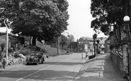
Just this side of it can be seen the premises of Botley Garages, now a sports shop and a hairdresser's. The swinging AA sign has gone, replaced by one for the sports unit.

If there is any breeze blowing, it will blow onto Clee Hill, and consequently the village can sometimes be very bleak.

Notice the old Town Hall on the right hand side of the photograph – now sadly destroyed and replaced by an extremely bland 1960s building.

The first forge is reputed to have been working in 1425, with the first ironworks following in 1577; it is also said that the first forge in America was built by emigrants from the town.

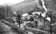
By the 1860s Bollington was thriving, but during the American Civil War the cotton towns of Lancashire, east Cheshire and north Derbyshire felt the effects of the Federal blockade of Confederate ports.

The horses and ponies which pulled the carts were stabled behind the town's many inns, where they were fed, watered and rested, ready for the journey home.

Even so, the population then was about 6000.The town’s development received a boost in 1945 when Rover announced their intention to abandon their Coventry plant and concentrate production at their

Lowestoft's convalescent home was a gift to the town in 1877 from William Birbeck, who was himself ill – he died in 1897.

The use of the word 'gate', meaning a road or street, comes from the Old Norse 'gata', and is another clue to the antiquity of the town.

In Wallingford's town centre is a fine Market Place.

Before the area was opened up for coal mining Ashington was but a farm; it was the Ashington Coal Co who developed the town, building 300 houses for pitmen and their families.

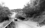
It is high summer, judging by the height of the River Teign and the shirt sleeves of the farm labourers.

Now known as Crown Square, this busy junction at the centre of Matlock has always been the hub of the town.

This card represents some other aspects of the life in and around the town in the 1960s.

Fore Street, leading into the A350 Trowbridge Road, is now a very busy road in and out of town.

The Parade was built in Georgian times as the fashionable residential quarter of the town. Near here, members of the royal family would stay during and after the reign of George III.

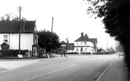
In the earlier years of the 20th century, Bere Regis had a reputation as the toughest town in Dorset, forcefully policed by the local constabulary.

But apart from the motor cars and the considerable increase in visitors, the town has changed little since Thomas Hardy worked here as a young architect a century earlier.
Places (26)
Photos (23)
Memories (3719)
Books (3)
Maps (195)

