

Photos
Sorry, no photos were found that related to your search.
Maps
9 maps found.
Books
2 books found. Showing results 601 to 2.
Memories
561 memories found. Showing results 251 to 260.
The First Holiday At Potter Heigham
We hired a riverside chalet called 'La Dak' on the Martham side of the river, there were two families sharing. I remember there was no car access to the chalet so we had to park the cars next to the bridge ...Read more
A memory of Potter Heigham in 1968 by
Leaving School
So! Back to 11 Woburn Place, back to school on Hope Chapel Hill back to Hotwells golden mile with its 15 pubs. The War was still going on but there was only limited bombing and some daylight raids, the city was in a dreadful state ...Read more
A memory of Bristol in 1945 by
School Road And Area
I was born in School Road, just off the High Street in 1943 and lived there till 1968. I remember Inwood Park with the boating lake and the paddle boats. The paddling pool, the tennis courts and the playground. I worked for four ...Read more
A memory of Hounslow in 1951
Trecco Bay
In 1958/59 my mother-in-law Elsie Pugh has been cleaning the toilets for several years in Trecco Bay together with her husband Albert. My husband Roy Griffiths also worked on the site. We got married in 1960 and went to live in Trecco ...Read more
A memory of Porthcawl in 1961 by
Hedgemans Road To Goresbrook
My parents moved to the Becontree Estate in about 1926 and we eventually settled in Hedgemans Road overlooking the field near Talbot Road. In those days the council used to decorate a couple of rooms as well as keep the ...Read more
A memory of Dagenham in 1920 by
My Years Growing Up In Clovelly
My name is Sam Burrow I was born in Hartland in 1936 - the family moved to Clovelly in 1939 and lived in Home Lodge. My father, J A Burrow, was the estate foreman. My mother, Florrie, was the school cook throughout ...Read more
A memory of Clovelly in 1949 by
Jaywick Holidays In The 60's And 70's
Myself and my family have great fond memories of our yearly holidays in Jaywick. There would be mum, dad and us 4 kids and we would stay in Meadow Way usually, I think it was number 322, almost opposite the Las ...Read more
A memory of Jaywick by
Blundellsands
Memories include, the erosion, sniggery woods, coronation park and the erratic glacier boulder, the boating lake. Fort Crosby, the bike shop at Brighton-le-sands. The swimming pool down on the shore, the big houses down merrilocks ...Read more
A memory of Blundellsands in 1960 by
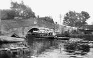
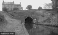
The Braunston Tunnel
A short distance north-west of Daventry is Braunston. The village lies on a hill overlooking the Grand Union Canal, one of Britain’s most famous inland waterways, and is a hub of the canal network. This photograph (D83014) shows ...Read more
A memory of Daventry in 1955 by
Summer Holidays
When we all broke up for 6 weeks holidays it was all the kids jobs to go in 'the cut' and swim to fetch coal out. The boats used to carry the coal from Walsall Wood pit to Birmingham and the boater used to drop lumps of coal ...Read more
A memory of Rushall by
Captions
650 captions found. Showing results 601 to 624.

This view is looking towards the town centre, and the boat ('BN3', a Boston-registered boat) is heading out to the Wash and the North Sea.

During the floods of 1947, the River Ouse rose over the gardens of the twelve houses in River Terrace and drenched the ground floors.

It was on the sands here that the French invasion army laid down its arms — with the exception of 25 who could not attend due to temporary incapacity (they were ill or probably drunk on looted

Tenterden is a beautiful old Kentish town close to the Rother Levels. It grew fat in the Middle Ages on sheep, wool and weaving, and later became a market town.

Presiding over the town's broad High Street is the 120 feet high, pinnacle-topped tower of St James', which dates from the 15th century.

This is a historic lost view of Lyme's eastern cliffs before they were entombed and extended in 1984, by sea defence works which incorporated and hid sewage disposal facilities.

These women players are at a considerable disadvantage with their long, billowing dresses and broad-brimmed headgear.

South of Lincoln a string of villages grew up along the western edge of the limestone ridge, mostly along the spring line.

Broad Street is a later medieval planned extension of the market place, which is beyond the end houses.

The town of Bodiam is dominated by one of the most picturesque castles in England, set within a broad moat filled with golden carp.

The Teifi begins its journey to the sea 70 miles away; it provided an inland route for the Normans to service the castles of Cardigan and Cilgerran.

The heart of Georgian Weymouth overlooks the sands from the Gloucester Hotel (top left) and the Royal Hotel (centre left), in a broad sweep around to the Victorian spire of St John's Church and Brunswick
These women players are at a considerable disadvantage with their long, billowing dresses and broad-brimmed headgear.

The village of Hampstead Norris nestles in a shallow valley, the buildings dominated by the short broad tower of St Mary's church in the background.

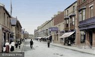
'A walk through the streets on a summer's day half-a- century ago ... was different in many respects.

The vicar of Holy Trinity Church in the mid 19th century was the Rev Edward Lyon Berthon.

A place familiar to all train travellers through Devon, Dawlish nestles across the sides of a broad combe, with the railway line protecting the town from the sea.

While the neighbouring resort of Margate had been attracting hordes of trippers from London from 1753 onwards, Westgate remained a more sedate and favoured place for families throughout the late

This broad open space at the heart of the city is a kaleidoscope of noise and colour on market day.

The main shopping areas of Broad Street and Church Street have not changed too much in character since the camera clicked on this scene.
While the neighbouring resort of Margate had been attracting hordes of trippers from London from 1753 onwards, Westgate remained a more sedate and favoured place for families throughout the late

This broad parade, named after Queen Victoria, runs along the East Cliff in front of Wellington Crescent and the lawns.

Aberaeron is almost in the middle of the 60-mile coastline of Ceredigion. In 1800, Aberaeron was little more than a farm and inn by the main coast road where a bridge crossed the Aeron.

On the left bank is the single track Bristol & Portishead Pier & Railway, which opened as a broad gauge line in April 1867 and was worked by the Bristol & Exeter Railway.
Places (0)
Photos (0)
Memories (561)
Books (2)
Maps (9)

