Places
5 places found.
Those places high-lighted have photos. All locations may have maps, books and memories.
Photos
9,649 photos found. Showing results 2,361 to 2,380.


Maps
18 maps found.
Books
13 books found. Showing results 2,833 to 13.
Memories
4,612 memories found. Showing results 1,181 to 1,190.
Chilhood Memories In Rhuallt
I remember moving to Rhuallt. I was 3 or 4 yrs old and on my first day at school, Miss Jones the infants teacher took me to see a swallows nest so my mother could go home. Roller skating down the old road straight on ...Read more
A memory of Rhuallt in 1960 by
Tricorn And Charlotte St
I worked at Fine Fare and the Landport Drapery Bazaar in 1970/71 and was a member of the Tricorn Club on top of the Tricorn. My favourite locals were the Coxs Hotel and the Casbah Pub both in Charlotte St. The landlord ...Read more
A memory of Portsmouth in 1971 by
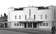
The Old Odeon.
If you walked around the first corner to the Odeon you got a good view of the old Blast Furnaces that use to turn Corby's night sky orange. It never got dark in the Corby of my childhood. The Candle and all the steel and tube mills lit ...Read more
A memory of Corby in 1962 by
Memories Of The Gareloch
I remember Garelochhead well. I lived in the village. We made big swings with rope over the trees at the back of my house in Dunivard Place - I nearly killed myself on them lol. We played rounders and used to knock ...Read more
A memory of Garelochhead in 1960 by
The Charles Family Home At 39 Cwm Road.
39 Cwm Road in 1946 The family home, at 39 Cwm Road, was on the ‘cellar side’, which was deemed to be an advantage, since the houses were three-storeyed and sported an extra kitchen, scullery and pantry, ...Read more
A memory of Waun Lwyd in 1946 by
71 71a Heswall Busses
I can remember coming back across the Mersey on the ferry boat and getting a bus home. 71a right to the top of our road. 71, a walk home from Irby Village. or the Crossville Heswall bus and walking form Pensby. I was much fitter then ......
A memory of Birkenhead in 1960
Growing Up In Sutton
We lived at no 6 Greenfields, Sutton. My nan lived at four with my grandad Tom - in fact it was my family which helped forge Sutton village. I remember many families; Mr and Mrs Harland who ran the village ...Read more
A memory of Sutton by
Grandma Knox
My Grandma Iva Knox lived in Kibblesworth and was a seamstress. She used to make the uniforms for the jazz band among other things. She lived in a flat opposite Miss Cooper and above Mrs. Ward. Colin Wilkinson lived opposite ...Read more
A memory of Kibblesworth by
The Round House
Pip Parkinson's memories are so similar to my own that we could have been on the same holidays. I first went to Shaldon with my parents in 1952 and we returned for one week at Easter and two weeks in August every year for the next ...Read more
A memory of Shaldon in 1957 by
Chinbrook Estate
I moved to the Chinbrook Estate in 1965 when I was 10 years old. When I was older I spent many an evening in the Chinbrook Public House, I can remember seeing Acker Bilk play there. As children we used to go to the Tarn, ...Read more
A memory of Mottingham in 1965
Captions
5,016 captions found. Showing results 2,833 to 2,856.

This scene is still instantly recognisable from the green, where seats encircle a shade giving tree.

Grindleton is a classic case of village development: here ancient roads cross, and ribbon building took place along those roads.

Standing on the bank of the Great Ouse about a mile from the centre of Kempston, the parish church is a stone building wherein the tower, at least, is Norman in origin.

The Diamond stone sits alongside the Devizes to Swindon main road that goes through the village.

The pub fronts Main Street, sitting prominently at the junction of Cosby Road and Station Road, and appears to be the bad conversion of a former row of cottages.

When factories arrived in the village in the 19th century, development along the Wistow, Saddington and Kilby Roads was inevitable.

This is a 16th-century building par excellence, much altered and added to down the centuries; it is timbered, tile hung and jettied, and bears a cluster of tall chimneys.

We are on the slope of the Downs between Eastbourne and Polegate. A nearby vantage point at Combe hill is 638 feet high.
The pub fronts Main Street, sitting prominently at the junction of Cosby Road and Station Road, and appears to be the bad conversion of a former row of cottages.
When factories arrived in the village in the 19th century, development along the Wistow, Saddington and Kilby Roads was inevitable.

Situated on the south-west side of the village, the church was heavily restored by Frederick Peck of Maidstone in 1872.

The parish church is a remarkable one, funded reputedly in the mid 15th century by two wealthy unmarried sisters from Toddington in Bedfordshire - the Peover sisters' generosity is commemorated in the village

The parish of Abbots Ripton lies a few miles north of Huntingdon. At the time of the Dissolution it was held by Ramsey Abbey.

The old town of Cliffe, destroyed by fire in 1520, was revived briefly by the cement industry in the second half of the 19th century.

Many of the houses here have the initials NEC, standing for the New England Company that once owned the parish. On the left is the post office, which closed in the 1980s, and the Chequers Inn.

Under the spreading chestnut trees of St Mary`s churchyard, and on the opposite side of the village street, the photographer`s activities generate much interest from a mixed audience of both children

Heading east away from the Mendips onto the rolling eastern Somerset countryside, we reach Nunney.

A Saxon hill village, known as Gumeninga Hergae, or the shrine of Guma's people, in 767, it has now become well and truly subsumed into suburbia, and into Betjeman folklore through his poem of the same

Harcourt is taken from Harcourt in Normandy, and from Roger de Harewecurt, who held the village in 1202.

In the main, this is a large red-brick village, but a few thatched stone cottages remain, as in the photograph - note its superb hedges and simple topiary.

South Luffenham on the river Thater is a 7th-century Saxon settlement with North Luffenham, now adjacent to the A6121 Uppingham to Stamford road to the north, an attractive village of narrow streets and

This is a village in two halves, High Town and Low Town, a quarter mile apart. Land around here was once one of the royal hunting grounds. The White Horse, a chalk hill figure, was carved in 1857.

A view of this remote village, the largest settlement on Achill. Behind is Croaghaun, almost 2,200 ft high, which on the far side drops precipitously to the Atlantic.

Loughgall is an attractive Armagh village on the minor road between Portadown and Armagh. This view shows a quiet scene with only a few motor cars.
Places (5)
Photos (9649)
Memories (4612)
Books (13)
Maps (18)

