Places
Sorry, no places were found that related to your search.
Photos
134 photos found. Showing results 41 to 60.


Maps
896 maps found.


Books
4 books found. Showing results 49 to 4.
Memories
542 memories found. Showing results 21 to 30.
Pav's Tea Gardens, Westgate
Pav's Tea Gardens in St Mildred's Bay was a place where I spent my youth, owned by Herbert Smith the famous film producer, the cafe was full of stills from the films he had worked on, there must have been over ...Read more
A memory of Westgate on Sea by
Bombing Raids In 1940
Bristol's premier shopping centre was turned into a wasteland of burned out buildings after major bombing raids in 1940, during the Second World War. Bridge Street Summary Bridge Street ran from High Street, rising up a ...Read more
A memory of Bristol by
Robin Hoods Bay
Whilst in Clovelly on my overseas trip I met a couple who suggested if I love Clovelly, I would love Robin Hoods Bay. So whilst in Whitby I took a bus there and enjoyed a leisurely meander down to the water. It was lovely with beautiful views.
A memory of Robin Hood's Bay in 2010 by
The Gables In Maldon
Re Bob Warren. I was 11 yrs old in 1964 but was only there for maybe 6 months. Mr Goslin still had two legs then. I never saw him use the cane but I had a bunch of keys hit me round my head from his wife and a member of ...Read more
A memory of Maldon in 1964 by
Growing Up
I moved to Millbrook in 1950 and spent my formative years there - it was a great place to grow up in. We lived in Myrtle Cottage, next to my uncle's farmyard. We used to roam the countryside for miles with never a worry. It was such ...Read more
A memory of Millbrook in 1961 by
Exiled To Fair Oak
During 1957, at the age of 13 I was 'sent' to live with an elderly Aunt in Burnetts Lane. I attended the local school and made many friends in the area. My Aunt's name was Fanny Godwin. Her neighbours on one ...Read more
A memory of Fair Oak in 1957 by
Completely Changed!!
My father took my mother and I on holiday to Woolacombe every year in the 1950's. At that time, in the height of the Summer months we would be the only family on the main beach (as well as the Barracane Beach where we ...Read more
A memory of Woolacombe in 1950 by
I Know All The Memories Of Tynemouth
I was born in North Shields and know all the photos shown ...was my school holidays. I married my husband, a Northumberland Fusilier from Haltwhistle in January 1959 and in April we left from Newcastle on ...Read more
A memory of Tynemouth in 1959 by
Lost Village Of East Holywell
I was born in East Holywell in 1946 and lived at 24 North Row. By then there were only 2 rows of houses left. We lived with my grandmother, Eva Barnfather, who had been there since the turn of the century. Like ...Read more
A memory of East Holywell in 1950 by
The Halcyon 1950's
I lived with my family in Connaught Gardens from being born in 1949 to late 1960 when we moved to Shiremoor. At the end of our street was an overgrown, rubble strewn wasteland which we called 'The Croft'. A natural childrens ...Read more
A memory of Forest Hall in 1950 by
Captions
870 captions found. Showing results 49 to 72.

This view looks across the bay, with the chalk height of Beer Head in the far distance. Among the pebbles on Seaton's beach may be found jasper, beryl and garnet.

Totland Bay is the westernmost inhabited bay on the Isle of Wight, with views up the English Channel to Bournemouth and the Dorset coast.

Just over a mile separates this popular sandy bay from St Ives. Above the coast path at Porthminster Point lived the 'Huer', whose job it was to watch for the arrival of the pilchard shoals.

Victorian entrepreneurs sought to transform little West Bay into a major resort, but they did not succeed, probably because of the considerable competition from neighbouring watering places.

It is some twenty years on from photograph number 44810, and West Bay has changed little. Note the bathing tents on the promenade.

The fishing village of Robin Hood's Bay lies just a few miles to the south of Whitby. Also known as Bay Town, the village became a favourite haunt for artists and holidaymakers alike.

This is Main Bay, which changed its name to Viking Bay following the arrival in 1949 of a replica Viking ship, the Hugin.

Outside the hall, Nicholas Sotherton's traceried bay window is flanked by Francis Cock's staircase bay of a century later. Both were added to a 15th-century structure.
Outside the hall, Nicholas Sotherton's traceried bay window is flanked by Francis Cock's staircase bay of a century later. Both were added to a 15th-century structure.

The Working Men's Club Union Convalescent Home at Pegwell Bay had a Mrs M E Boyland as superintendent, and B T Hall as secretary.

It is low tide in this view looking towards the slipway and the Bay Hotel. The Bay itself sweeps around from Ness Point in the north to the 600ft high cliffs of Ravenscar, at the other end.

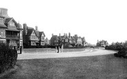
Two miles west of Margate, Westgate on Sea has two bays; sea walls built along the curves of the bays form two promenades with steps down to the beach, and gardens are laid out for the benefit of visitors

West Bay has now become the setting for a popular television series, 'Harbour Lights', which has brought many more tourists to the village.

Here we see Swansea Bay Station and the Slip. A fairground, market, ice-cream stalls, and so on were all to be found here in their day. The

The Cliffe Hotel was a very popular hotel in Victorian days.

This general view looks west over the bay towards the town. Beyond the pier, which appears to be under construction, is Bryn Euryn, and Little Orme Head is in the distance (right).

Here we have a closer view of the wall and walk built from the cliff opposite, encompassing the ground later laid out as gardens, and earlier as a swimming pool, by the Pegwell Bay Reclamation

This view shows the headland that separates the two bays. The northern (further) bay penetrates well inland and provided good shelter for boats, with limekilns, storehouses and coal yards nearby.

This view shows Carbis Bay when it was still largely undeveloped, with just a scattering of houses above the cliffs overlooking the sandy beach.

The central bays of the promenade building survive, but the arched bays on each side were rebuilt in the 1950s.

St Mary's can be seen to the right. Slightly to the left is Brownston House, one of only two Grade I listed buildings in town. It was originally built in 1700, but was rebuilt later in 1720.

Greenodd stands on the Leven Estuary where the River Leven from Windermere and the River Crake from Coniston Water flow into Morecambe Bay and the Irish Sea.

This splendid early 19th-century house is the former rectory. The symmetrical front has five window bays; the central bay over the porch has rounded tops.

The sweep of Lyme Bay and the attractions of the Exe estuary had made Exmouth a favoured resort for those who wanted to take to the water for a small voyage.
Places (0)
Photos (134)
Memories (542)
Books (4)
Maps (896)

