Merry Christmas & Happy New Year!
Christmas Deliveries: If you placed an order on or before midday on Friday 19th December for Christmas delivery it was despatched before the Royal Mail or Parcel Force deadline and therefore should be received in time for Christmas. Orders placed after midday on Friday 19th December will be delivered in the New Year.
Please Note: Our offices and factory are now closed until Monday 5th January when we will be pleased to deal with any queries that have arisen during the holiday period.
During the holiday our Gift Cards may still be ordered for any last minute orders and will be sent automatically by email direct to your recipient - see here: Gift Cards
Places
26 places found.
Those places high-lighted have photos. All locations may have maps, books and memories.
- Town End, Derbyshire
- Town End, Buckinghamshire
- Town's End, Somerset
- Towns End, Dorset
- Town End, Merseyside
- Town End, Cambridgeshire
- Town's End, Buckinghamshire
- West End Town, Northumberland
- Bolton Town End, Lancashire
- Kearby Town End, Yorkshire
- Town End, Cumbria (near Grange-Over-Sands)
- Town End, Cumbria (near Bowness-On-Windermere)
- Town End, Yorkshire (near Huddersfield)
- Town End, Yorkshire (near Wilberfoss)
- Town End, Cumbria (near Appleby-in-Westmorland)
- Town's End, Dorset (near Melbury Osmond)
- Town's End, Dorset (near Swanage)
- Town End, Cumbria (near Ambleside)
- Town End, Cumbria (near Lakeside)
- Town End, Cumbria (near Kirkby Lonsdale)
- Town End, Cumbria (near Ambleside)
- Town's End, Dorset (near Bere Regis)
- West-end Town, South Glamorgan
- Townend, Derbyshire
- Townend, Strathclyde (near Dumbarton)
- Townend, Staffordshire (near Stone)
Photos
26 photos found. Showing results 581 to 26.
Maps
195 maps found.
Books
160 books found. Showing results 697 to 720.
Memories
3,720 memories found. Showing results 291 to 300.
Sadly The Palm House Has Gone
I am the current owner and restorer of the former Town Hall. It was originally called Whitehall and is now called Mossley Hall. The Palm House in the picture was removed, along with the stained glass Atrium over the ...Read more
A memory of Mossley in 1958 by
Great Place To Grow Up
My dad, Adam Pagan, was a great dad who loved his town and told me loads of Maryport history about links with the mutiny on the bounty. I loved going on the shore and the fair coming. When I was young I lived in Kirkby ...Read more
A memory of Maryport in 1950 by
Blackmill
My name is Beth McMillan - Mckay then. Now living in New Zealand. We lived in Glyn-Llan but I spent many a hour walking up and down that road to Blackmill, getting the shopping in the Co-op and little shop/post-office on the corner. ...Read more
A memory of Blackmill by
Southdown Bus Station And Clair Meadow
I used to play in the old Clair Meadow and remember the drinks machine which sold pink milk in a wax carton by the tree at the footpath entrance to 'the rec' on Perrymount Road which is still there...I ...Read more
A memory of Haywards Heath in 1969 by
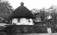
My Ancestors Lived Here
I recently visited this 'dutch cottage' again (after taking my mum there in the 1990's) and the girl who lives there and is the also the guide, is full of good information about this. She was surprised when I said that my ...Read more
A memory of Rayleigh in 1880 by
Uxbridge, Windsor Street
I had forgotten Suiters 'quirky' cash system but I do remember another store called Manettas which was to the right of Uxbridge station. In 1966 it caused an uproar in town as it displayed a topless dress, which was the ...Read more
A memory of Uxbridge by
Former Pupil 1957 1963
My maiden name is Lynda Roworth, and I have fond memories of attending Rotherham High School for Girls. I played hockey (right wing) for the school team - Christine Cutts was the first captain I remember. We rarely had ...Read more
A memory of Rotherham by
Carnival Day 1932
Southend carnivals were always a wonderful attraction and Mrs Olley, then 22 years old, remembers boarding HMS HOOD on it's visit to the town in 1932.
A memory of Southend-on-Sea by

Upper Day House
The women of my father's family decided to go to Shropshire to get away from the bombs in London. There were about 7 women, mostly Harts, who went & rented Upper Day House with their children, about 10/11 children. The ...Read more
A memory of Church Preen in 1941 by
Twickenham In The 60's
I lived and worked in Twickenham from 1962 and 1969. I lived at 125, Staines Road and worked for the Metropolitan Water Board, based at a small depot in Nelson Road, close to the fish and chip shop. I was what was ...Read more
A memory of Twickenham by
Captions
5,111 captions found. Showing results 697 to 720.

Princetown is an unlikely spot for a town—1400 feet above sea level, on an exposed col between North Hessary Tor (top left, without the TV mast that adorns it today) and South Hessary Tor, and with

This picture, taken just where the A469 road to Bargoed turns to the left, shows what a diversity of shops and amenities existed in a town of barely 5,000 inhabitants.

The creeper-clad Dinorben Arms Hotel (left) and the Eleth Hotel provided good quality accommodation in the 1930s.

Military flags hang on the wall of the north aisle (left), for the Duke of Cornwall's Light Infantry has close associations with the town and church.

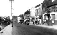
The view down the town's busiest trading place begins with grocer and wine merchant Sarah Chapman's shop front (left) facing the Volunteer Inn (far right), where the landlord was Tom Searle.

This view across what is now known as the Peace Gardens towards the mock-Gothic spires of Sheffield's Town Hall has not changed significantly since this photograph was taken.

St Lawrence's Church was built in the Perpendicular style, and features a number of grotesque gargoyles that stare down from the eaves.

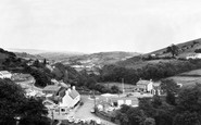
Moving east off The Wolds, our tour reaches the flat land between them and the sea, with its high line of rolling marram-grassed sand dunes as a backdrop.

The two townships of Poulton-le-Fylde and Hambleton, linked by the bridge, were villages when the bridge was first built to serve agricultural communities.

The town's identity is linked to the magnificent white horse cut into the chalk hillside, a landmark which guides the traveller.

As we approach the town, it is possible to see cranes rising above the waterfront of this busy port. Harbour Road is close to the sea. Both the Angel and the next building are clad in weatherboard.

Fore Street once had many thatched cottages and a stream running down one side, but it was rebuilt in the 19th century, when the town prospered with the woollen industry.

Continuing south-east across Ashdown Forest, the tour finishes at Uckfield, a town now by-passed and the terminus of a commuter railway line to London, the continuation to Lewes having been closed.
Upper Rushall Street and Peal Street running north and south from the bottom of the church steps indicate ancient routes to Lichfield and Wednesbury.

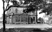
The Palace, designed by the illustrious London architects Ernest George & Peto and built in 1882 at the then enormous cost of £20,000, was funded by Viscountess Ossington, sister of the 5th Duke of

Swanage spent much of the 20th century developing as a holiday resort, though the town never seemed quite sure whether to try to appeal to the masses or the more exclusive visitor.

This is down-town Lydney in the days when books could be loaned from the newsagents for a few coppers a week via the Argosy Lending Library, and a liquid night out at the Fleece could be had for less than

A century after his visit, the town had been transformed from a quiet village to a vibrant part of the textile industry.

Cudworth was never a pit village, although it is surrounded by collieries at Monk Bretton (opened in 1870), Carlton (1879), Grimethorpe (1897), Frickley (1905) and Ferrymoor (1917).

This bustling view of Church Road with its bicycles and horse-drawn vehicles is dominated by the sadly- lamented old Town Hall, which burned down in 1966.

Taunton is a town surrounded by water, with the Tone passing through its heart and the marshes not far away.

It is thought that the church steps were originally built in the early 14th century to enable access to the church from the old town, and at that time the steps were wooden, not stone.

As part of a commitment to education, the Wheatsheaf pub and King Edward VII School had to make way for a new College of Advanced Technology on Market Hill in 1957.

We are looking from the Town Hall down the grand vista of the largely 18th-century Market Place; it was known as the Shambles in the previous century, and designated for the sale of fresh meat
Places (26)
Photos (26)
Memories (3720)
Books (160)
Maps (195)

