Places
Sorry, no places were found that related to your search.
Photos
134 photos found. Showing results 81 to 100.


Maps
896 maps found.


Books
4 books found. Showing results 97 to 4.
Memories
542 memories found. Showing results 41 to 50.
The Beauty Of Herne Bay In A Hectic World
I lived in Herne Bay for my teen years. I remember the Pier burning down and the sea freezing over. The winds could be so strong my mother and I had to hold on to the lamposts for fear of blowing into ...Read more
A memory of Herne Bay in 1964 by
Schooltime Memories.
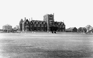
In the early 1940s the bay window on the first floor over the front door of Rotherham Grammar School was that of my second form classroom. On a rainy day we were 'attacked' by one of the other second forms as a result of which ...Read more
A memory of Rotherham by
My Years Living Next To The Butchers
My dad Rowland Cook took over Lasts butchers in 1985. I grew up in The Maltings which was attached to the shop and is the house on the right hand side of the photo with the big bay window from the age of 11 ...Read more
A memory of Botesdale in 1985 by
Happy Thoughts Of Bay
I believe I am the girl sitting on the grass looking towards the sea in this photograph. My name then was Susan Groves and my dad was a fisherman. We owned a shop down the bank called The Shell Shop where dad sold many ...Read more
A memory of Robin Hood's Bay in 1960 by
Old Port Bannatyne
This is a favourite view of photographers taken from McIntyre's Boatyard. In the distance you can see St Bruoc's church which burnt down in 1956. In the foreground is a boat hiring station, one of three in the village. ...Read more
A memory of Port Bannatyne by
The Plough In The 1930''s 40''s
The Plough my Grandad's (Jack Bartram) favourite watering hole, Granny claimed that with the money he spent there it should have belonged to the family. Landlord in those days was Mr Henry Castleman. The bay on the ...Read more
A memory of Byfleet in 1930 by
Chapmans Dairy.
This building was Chapmans Dairy and belonged to my family. It was originally two houses, numbers 22 and 23, with a stable at the rear for the ponies. The door now remaining led into the shop and the downstairs windows were bay windows. The whole building was painted white! How it has changed!
A memory of Hastings in 1940
Kennack
I have been coming to Kennack since I was a toddler. But 1972 was the first of many years that stand out to me. My family met another family and we are still in touch now, 36 years and more later. My memories are so many, borrowing ...Read more
A memory of Kennack Sands in 1972
Summer Of 67
I won the Cornish longboard championships at Constantine Bay in 1967. I was the profesional lifeguard at Treyarnon Bay in 1967 and 1968. Friendships established then and still true include Anhtony Richards, Robert Ede, David ...Read more
A memory of Constantine Bay in 1967 by
Wells Family In Thorpe Bay
A cousin found an old Birthday Book in which the names of some people from Thorpe Bay feature. We wonder if these were family members: Eileen Wells, 11 Plas Newydd, Thorpe Bay, Essex, Birthday February 28. Mrs. Day, ...Read more
A memory of Thorpe Bay in 1920 by
Captions
870 captions found. Showing results 97 to 120.

We are looking across Main Bay (now Viking Bay) towards the harbour, the pier and the prominent mansion Fort House (now called Bleak House), prior to its extension and castellation in 1901.This house

Wildersmouth Bay was the original bathing beach of the town; those beaches to the west only became accessible after the drafting in of Welsh miners to dig the tunnels by which they are now reached.

West Bay is the small port of the neighbouring town of Bridport.The River Brit, which gives the larger town its name, is held back by a series of sluices and released at low tide.

Round the corner to the Eastbourne Road, with The Bay Hotel on the right, the architectural quality drops sharply to typical seaside nowhere.

This scene has hardly changed for many years; the beach at Polridmouth is still only accessible on foot.

The Great Barn of Abbotsbury Abbey was built in about 1400.

The bus station was built to incorporate a parade of shops, seen here beneath the canopy.

The harbour is the site of the original Tor Quay, which served the little village of Tor Mohun inland.

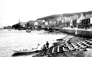
Rothesay is the chief town of the County of Bute, and is situated in a well-formed bay, which affords safe anchorage in high wind.

Bridport haven, an estuary under East Cliff, became Bridport Harbour as we know it in the 18th century, with the final layout taking shape in 1824.

Llandudno stands back against the mass of the Great Orme's head, which shelters it from north winds, and on a neck of sand between two bays, which are so close together that in rough weather their spray

The latecomer amongst Dorset's holiday haunts (the author Thomas Hardy called it Port Bredy), West Bay hamlet grew up around historic Bridport Harbour (centre) and its double piers, which protect a ship

On the lane south from the crossroads the last two houses on the left are timber-framed, the White Cottage on the left with original framing in the side elevation and fake to the front.

Rothesay is in an ideal location in the sheltered 'sweet Rothesay Bay', to quote the popular song. It is the county town on the eastern side of the Island of Bute.

This view looks north-eastwards from East Cliff, over the older administrative and commercial heart of what used to be called Bridport Harbour.

Immediately south of the church whose spire can be seen behind, is The Bury.

Part of the old Ramper Road, this end of Victoria Road passes the Congregational church where Mr W Gornall was a great supporter.

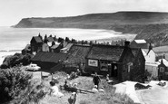
Robin Hood's Bay is one of many beautiful villages which cluster around the steep-sided coves where the North York Moors reach the North Sea.

The paddle-steamer is not approaching the Cobb wall on a busy day.

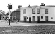
The earlier pub on the site, made famous by the music hall star Florrie Ford, was demolished in the early 1920s, and rebuilt to a vaguely similar design.

The original timber building, dating from c1580, has two gables; the brick extension to the right is 19th-century.

The spectacular rock formation of Filey Brigg at the north end of the bay.

Chalets, a villa and the Bay View Hotel overlook the Hive and Burton Beach from the end of Beach Road. The sandy rocks of Burton Cliffs project towards Lyme Bay (left).

Fleetwood became England's principal fishing port on the west coast with a fleet to rival those of Hull and Grimsby. In this picture there are trawlers and Morecambe Bay prawners.
Places (0)
Photos (134)
Memories (542)
Books (4)
Maps (896)

