Places
7 places found.
Those places high-lighted have photos. All locations may have maps, books and memories.
Photos
297 photos found. Showing results 81 to 100.


Maps
28 maps found.
Books
Sorry, no books were found that related to your search.
Memories
357 memories found. Showing results 41 to 50.
The Capitol Cinema
I remember being taken to the Capitol by my sister to watch the Disney film Bambi. We sat through it three times, I was taken ill the next day and my sister got the blame. The Capitol had a ventilation fan under a hole in the ...Read more
A memory of Barking in 1950 by
Christmas
I always think of East Ham at Christmas, going to the Co-op to see Father Christmas, it seemed like magic how they did it. Then when older I remember my dad sat down our shed at 61 Stokes Road plucking chickens, he kept chickens in our ...Read more
A memory of East Ham by
Evacuee From London
Dear Sir/Madam. I am at present researching my childhood days at 86,Easton Street Boys Hostel, High Wycombe. I do remember walking to school with other boys alongside the Wye River. The name of that school escapes my ...Read more
A memory of High Wycombe in 1949 by
Sileby My Early Life
I was born in Mountsorrel 1938 and soon moved to Sileby 10, Mountsorrel Lane with my mother Mabel Foukes [nee Burton]. My father Thomas was in the army and my mum worked at Newbold Burton and Lawson Ward. I remember convoys of ...Read more
A memory of Sileby in 1940 by
Great Horton
Our family lived in Lidget Green, near the Great Horton railway station. I was born in 1949 near Bradford (Wakefield), and lived in Lidget Green from toddlerhood until we emigrated in 1960. The neighborhood provided many memories ...Read more
A memory of Bradford in 1959 by
The Heap Family/ Lovick Family
My dad was born in 1923 at 23 East Street, Barnoldswick. He was born out of wedlock to Lilian Victoria Heap; who lived with her father, Harry Heap, in East Street. My father, Harold Heap, had very few memories of ...Read more
A memory of Barnoldswick in 1920 by
The Cross
Most of the names state the obvious. This is an important crossroad. Turn right to go to Mill Green along Mill Lane. Turn left to go to Vye's Stores (pre-1960) and then to the Church in Church Lane or down Brook Lane, where we assume the ...Read more
A memory of Eastry by
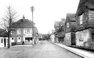
Petworth Road (Formerly East St)
This is a picture of the Petworth Road (formerly East Street), looking away from Haslemere High Street.
A memory of Haslemere
Thatcham 1951 1962
The shop opposite the White Hart public house, owned by Simonds, was called Lays Stores. My mother and father bought it in 1952 and ran it till it closed in 1962. Before that, they owned the fish and chip shop which has now ...Read more
A memory of Thatcham by

Memories Of St Peters And Broadstairs
I was born at 19 Church St, St Peters, where my grandfather owned the butchers shop. My first memory is of playing on the lino floor just inside the front door. My father, who served in the RAF during the ...Read more
A memory of Broadstairs in 1950 by
Captions
445 captions found. Showing results 97 to 120.

A view looking east along the green to Trinity College, with the Bank of Ireland on the left. This bustling scene shows a horse-tram snaking over the cobbled street.

From the south-east, a look at the Institute, which has now sprouted a clock, put up in 1891 in memory of Thomas Cramp, the town's diarist and total abstainer.

A suburb to the east of Warrington, this is still a mainly residential street. The houses on the left have now all gone, to be replaced by bungalows for the elderly.

Waddington is now noted more for its large Royal Air Force station to the east of the village, but it grew up on a diversion of Ermine Street to the western scarp of the limestone ridge.

This photograph shows the Cannon Street end of King William Street, which heads south-east from the Mansion House towards London Bridge.

This brief tour of Stamford has now climbed up to St Mary's Street to look east past the north nave aisle of St Mary's Church to the Stamford Hotel, somewhat over-large for the narrow street and towering

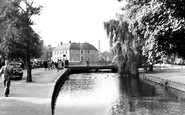
From Stour Street we head north along the river. This photograph was taken from the railway line looking east across the Stour.

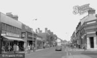
Our photographer now proceeds east along the High Street, a relatively narrow street with a mix of 17th-century and later fronts, now pedestrianised.

East Blatchington village has changed radically since this view was taken. St Peter's Church is still there.

East Blatchington village has changed radically since this view was taken. St Peter's Church is still there.
This photograph shows the Cannon Street end of King William Street, which heads south-east from the Mansion House towards London Bridge.

Looking east along Tavern Street from Cornhill.

In King Street, east of the castle, this church has been redundant since 1981.

The town, separated from The Wolds to the east by thin sandy moors, now mostly afforested, became the main market for a wide area in the 16th century, and changed its name from East to Market Rasen.

Further west the photographer looks east along the Parade with the ornate iron archway into the former Esplanade Park.

The last view in Marcham was taken from the parish church tower looking south-east towards Parkside, a large estate of 1950s former council houses.

From North Curry, we skirt the south edge of West Sedge Moor to the town of Langport on the east bank of the River Parrett.

Even further north along the east side, much has now gone, with the New Town's modern shopping centre reaching the old High Street proper; but some of the spaciousness in the distance remains.
Our photographer now proceeds east along the High Street, a relatively narrow street with a mix of 17th-century and later fronts, now pedestrianised.

The High Street was named in the 13th century, when buildings were recorded east of Beeding Bridge.
Waddington is now noted more for its large Royal Air Force station to the east of the village, but it grew up on a diversion of Ermine Street to the western scarp of the limestone ridge.
In King Street, east of the castle, this church has been redundant since 1981.

The medieval street plan survives virtually intact, much of it based on the Roman town laid out in the first century AD.

This view looks east along the High Street, which lies on the Roman road between London and Colchester. High Street is rich in pleasing architecture, and the scene is little changed today.
Places (7)
Photos (297)
Memories (357)
Books (0)
Maps (28)

