Places
36 places found.
Did you mean: street or streetly ?
Those places high-lighted have photos. All locations may have maps, books and memories.
- Heathfield, Sussex (near Cade Street)
- Street, Somerset
- Chester-Le-Street, Durham
- Adwick Le Street, Yorkshire
- Scotch Street, County Armagh
- Friday Street, Surrey
- Potter Street, Essex
- Boughton Street, Kent
- Newgate Street, Hertfordshire
- Streetly, West Midlands
- Shalmsford Street, Kent
- Green Street Green, Greater London
- Boreham Street, Sussex
- Park Street, Hertfordshire
- Cade Street, Sussex
- Appleton-le-Street, Yorkshire
- Hare Street, Hertfordshire (near Buntingford)
- Romney Street, Kent
- Trimley Lower Street, Suffolk
- Streetly End, Cambridgeshire
- Hare Street, Hertfordshire (near Stevenage)
- Brandish Street, Somerset
- Colney Street, Hertfordshire
- Langley Street, Norfolk
- Silver Street, Somerset (near Street)
- Street, Yorkshire (near Glaisdale)
- Street, Lancashire
- Street, Devon
- Street, Cumbria (near Orton)
- Street, Somerset (near Chard)
- Bird Street, Suffolk
- Black Street, Suffolk
- Ash Street, Suffolk
- Broad Street, Wiltshire
- Brome Street, Suffolk
- Penn Street, Buckinghamshire
Photos
21,808 photos found. Showing results 1,121 to 1,140.


Maps
1,622 maps found.


Books
1 books found. Showing results 1,345 to 1.
Memories
6,666 memories found. Showing results 561 to 570.
Kathryn Trevelyan Nee Bennett.
I remember the houses opposite St.Theodore's as my cousin Veronica (Non) lived in one and the "Turners" (Pat, Shirley, Roy and others) lived next door. These houses had front doors in Higher Church St, while the ...Read more
A memory of Pontycymer in 1964 by
Mossband Camp
My father was a serving soldier, serving at the RAOC camp until 1948. We lived in the YMCA building in the camp itself and it had a large functions hall attached where one of our officers once entertained the children at Christmas ...Read more
A memory of Mossband Ho in 1947 by
Drake Street
I was born in Rochdale in 1934. I attended Champness Hall Sunday School, 1940 -52, which was situated just below the Rochdale Observer offices (on the left of the photo). It was a large Methodist Central Hall with offices used by ...Read more
A memory of Rochdale in 1952 by
My Birth Place
I was born in Templecombe Hospital on 13 April 1943, my mother was Lilian Game (nee Atkins) and was staying with her widowed father, Ernest Atkins of Silver Street, Wincanton, after leaving London because of the bombing during the war. My brother was also born there in September 1944.
A memory of Templecombe in 1943 by
Penzance Market Jew Street
As a boy I must have walked up and down Market Jew Street hundreds of times. In particular I along with friends would visit the local Woolworth's where we liked to partake of various flavoured "Milk Shakes" Later during ...Read more
A memory of Penzance in 1940 by
Mobo Horses
We moved to Prestatyn in 1948. I loved the Mobo horses that the little ones could ride at the Bastion Road beach. My little school was Pendre, up the hill Fforddlas I think. Also going to St Chad's School annual fair and sale. Always ...Read more
A memory of Prestatyn in 1950 by
Slag Heaps
I was born in Birks Road, Cleator Moor in 1954. I was from a large family called Sheldrake. We lived over the railway bridge towards the brewery. The neighbours that I know of are: the Watsons, the Moors, the Wrights, the ...Read more
A memory of Cleator Moor in 1954 by
Re Tony Bros Ice Cream
I remember Tony Bros ice cream parlour off Acton High Street. On some Sundays my father would take me for a treat for a cornet or wafer scooped out of the big drum on the counter, it was always after giving our dog ...Read more
A memory of South Harefield by
War Years
We lived first in Vinson Close, then in Glencorse in the High Street, next door to the Commodore. My friends included Eric Cox, who lived opposite in a flat over the undertaker's; Les Forrow, whose father was manager of a grocer's ...Read more
A memory of Orpington in 1940 by
Priory Road 1962 To 1988
My father, William J Smith (Bill) had a newsagent at 47 Priory Road between 1962 and 1988 which was opposite Ports the Bakers. I remember seeing queues of people coming out of the Bakers on a Saturday morning to get ...Read more
A memory of South Park in 1970 by
Captions
5,381 captions found. Showing results 1,345 to 1,368.

St Mary's church dominates the High Street skyline. Unique in Hertfordshire, Standon parish church has a detached bell tower and a porch at the west end rather than on the south wall.

Apart from bus stops, street lamps and motor cars, little else seems to have changed for perhaps half a century or more.

Street gaslighting was introduced into the city in March 1824, replacing earlier oil lamps.

The High Street used to be the main Norwich to London road. Here is a foretaste of the traffic problems that were to come.

We are looking downhill to where the High Street divides; it continues on as the right-hand fork. The lack of traffic is quite remarkable.

This is Park Street in the days before the top end was dominated by the Gothic tower of the university, designed by Sir George Oatley.

Although quite narrow and winding, this is the main street of the town, stretching for nearly a mile, and running parallel with the River Deben.

Laid out as an extravagant boulevard in the 1820s, Lord Street's many elegant buildings reflect the town's ambitions as a high-class residence and resort.

A fine view of Marsh Street, with its fine ivy- clad buildings and chapel. Again, only horse-drawn carts can be seen and all seems quiet.

The statue of Hull's leading writer, Andrew Marvell, has been moved; George Street became the new centre of entertainment. Bars, bistros and night clubs flourish here.

This view clearly shows the iron benches, railings and posts and the ornate street lamps. The earth road is in marked contrast to today's tarmac surface.

This is where Church Street meets Chapel Street. On the right we see the famous Hark to Bounty Inn, which was used as an area court house.

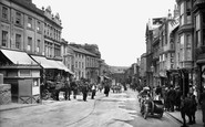
Here we have a splendidly detailed view of Godalming's High Street towards the end of the Victorian era.
The high Street used to be the main Norwich to London road. Here is a foretaste of the traffic problems that were to come.

This street, broad and uncluttered by traffic, is lined with Georgian and Victorian houses, and dominated by the splendid Victorian clock tower at the far end.

westwards up West Street to the Town Hall (left of centre), a Ford Model T passes the shops of Best, Warren and Spiller (right).

The Masons Arms (beyond), with its own stables, which stood opposite the junction with Newport Street, had parts of the building dating back to the late 17th century.

On the right is Union Street; the corner shop was W H Smith, but is now Oxfam. All of this part of the street was dug up during the extensive road works of early 2004.

Its broad, spacious street is fringed with brick and weatherboarded cottages in the Wealden style.

By the 1950s many of Stroud's locally-owned small shops were giving way to familiar chain stores, though the streets remained relatively free of motor traffic.

Above is the collection of elegant buildings that line the Esplanade and adjoining streets.

Looking down the street to the green hills of County Tyrone beyond. Note the kerbside petrol pumps on the right, a common Irish feature until recent times.

A classic rural Irish scene of this period, a pleasing main street, devoid of any traffic save for a farmer chugging up the hill in his tractor.

Facing south, Bury Villas are on the corner of Church Street (centre), which leads to the High Street.
Places (385)
Photos (21808)
Memories (6666)
Books (1)
Maps (1622)

