Places
36 places found.
Those places high-lighted have photos. All locations may have maps, books and memories.
- Bangor, County Down
- Newcastle, County Down
- Greyabbey, County Down
- Donaghadee, County Down
- Downpatrick, County Down
- Portaferry, County Down
- Dromore, County Down
- Hillsborough, County Down
- Downings, Republic of Ireland
- Killyleagh, County Down
- Ardglass, County Down
- Rostrevor, County Down
- Dundrum, County Down
- Newtownards, County Down
- Warrenpoint, County Down
- Ballygowan, County Down
- Ballywalter, County Down
- Ballyward, County Down
- Bishops Court, County Down
- Boardmills, County Down
- Culcavy, County Down
- Katesbridge, County Down
- Killough, County Down
- Millisle, County Down
- Portavogie, County Down
- Saul, County Down
- Seaforde, County Down
- The Diamond, County Down
- Audleystown, County Down
- Kearney, County Down
- Annaclone, County Down
- Ballyhalbert, County Down
- Ballymartin, County Down
- Clare, County Down
- Conlig, County Down
- Dollingstown, County Down
Photos
856 photos found. Showing results 101 to 120.


Maps
459 maps found.


Books
2 books found. Showing results 121 to 2.
Memories
8,167 memories found. Showing results 51 to 60.
Aveley Village A Special Place
Year ranges from 1961 to present really. My nan and grandad lived in Aveley, the Harmans, in Central Avenue. I have fond memories of staying with my nan and grandad, and the house in Central Ave, and across the road ...Read more
A memory of Aveley in 1963 by
Club Outing
Our ciu club in Watford came here for a weekend break. It was the Toby Club, as was called, that raised money for the old folks Xmas party. As we were from South Wales, my husband suggested we come down. What agreat time we all had!
A memory of Porthcawl in 1990 by
Peace And Open Spaces
I remember opening my front door and looking around at the beautiful views I could see. I could walk 100 yards in any direction and be in fields. The peace and quiet, and the views were outstanding. It took my breath away. I ...Read more
A memory of Holmfirth in 1980 by
Mountnessing School
I was at school in the 1940s. I remember a teacher there, I believe he was a Mr Davis. I remember the annual sports, these were held on a field just a short walk from the school. The days of the great snow fall in 1947, ...Read more
A memory of Mountnessing in 1940 by
Church On Kings Road
Does anybody have a picture of the church on Kings Road that was knocked down to build the International Hotel?
A memory of Harrogate by
Early Memories
My birth on 30 Nov 1946 at 34 Oldberry Road, Burnt Oak, is where it all started for me, but my mother & her parents moved into the house when it was built for the LCC. She's 89 now, but recalls that she, as a 9-yr-old in 1928, ...Read more
A memory of Burnt Oak in 1946 by
''tram Crash On Tabor Hill''
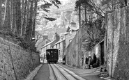
On Tuesday, August 23rd 1932 there occurred at almost exactly the same spot from which this photo was taken, the most serious runaway and crash that ever ocurred on the line. Car no. 4 broke away from the haulage cable ...Read more
A memory of Llandudno in 1930 by
Saturday Mornings At The Ritz
Me and my brother David would get our breakfast then run down Prospect Avenue North to the bus stop beside the shops and once in Clyde Street at Wallsend bus stops made our way to join the huge queue for entrance to the ...Read more
A memory of Byker in 1955 by
Long Hot Summer!
Spent many a hot summer lounging around with friends in Park Road, Gatley Hill (especially fishing for sticklebacks in the stream) and the school fields, not to mention the village. Great local shops owned by friendly local people. ...Read more
A memory of Gatley in 1975 by
Mine And My Mum Avrils Memories
My memories relate to the year 1977 when I arrived in Cropwell Bishop to stay with my Great Uncle Wilf and his wife Dorothy fresh from New Zealand. They lived at the old Post Office in the village of Cropwell ...Read more
A memory of Cropwell Bishop by
Captions
2,242 captions found. Showing results 121 to 144.

Graffham is a wooded hillside village under the Downs. Pescod's Stores has a Hovis sign on a painted wall.

Twin cataracts cascade down the limestone outcrop before joining together to descend almost gracefully forward and onward to tumble into the river, a thousand feet below.

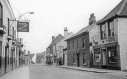
Further down the street are No 21 (formerly the Dorsetshire Bank), and the Three Cups Hotel (projecting, centre).

Looking down the street to the green hills of County Tyrone beyond. Note the kerbside petrol pumps on the right, a common Irish feature until recent times.

Steps cut into the rock lead down the cliff from Spit Point.

Down the slope the sgn of the Royal Oak Hotel hangs above the hand-cart; it was named for King Charles II, who was nearly captured on his escape into exile along this very street in 1651.

The High Street has attractive tile-hung and weatherboarded cottages tumbling down the hill.

We are looking down from Castle Park to Castle Hill and the city beyond. The Castle gateway is out of shot on the left.

This is a well-known beauty spot on the north face of Haytor where the Becka Brook hurtles down to join the River Bovey.

A sailing barge makes its way along the Orwell, with lush wooded hillsides coming down to meet the broad tidal mudflats at the water's edge.

A scene of a typical village pub: quiet, unassuming and somewhat down-at-heel, but an essential part of the fabric of English rural life.

We are at the top of Main Street, looking back down through the village from the bus station.

Since there is no evidence of Arthur ever existing, the claim that this is his grave is academic, though it would be foolish to ignore the power of handed-down legend.

Private boathouses line the river, and well manicured lawns sweep down to the water.

looks down towards the crossroads at the Guildhall. Opposite Godolphin Hall is the former Baptist Chapel, which became the Flora Cinema at about this time.

At this time, the buildings on the right are awaiting their fate - they were eventually pulled down. But they themselves had their origins in encroachment on the original larger medieval market place.

Alas, it was burnt down in 1930.

There is just room to draw up a few boats at this remote fishing cove down by the granite cliffs of Gwennap Head at the south-west corner of the Land's End peninsula.

The older generation, one with his newspaper, wait for opening time at this aptly-named pub down by the fishing harbour.

Now on the A25, this village lies between the north downs and the Leith Hill sandstone range.

It is shown here in its former splendour, with its famous gardens that sloped down to Lough Leane.

After the new Cut Channel was made, gas buoys were used, and the Ribble Port Authorities cut down the timber lighthouse. The first lighthouse of stone shone out before St Anne's had been built.

The single street leads down to the river. An Austin A30 is parked beside an Armstrong Siddeley. Originally these 18th-century red brick cottages were for estate workers.

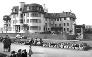
The donkeys have a long walk every day from their field just below the Abbey House, down the donkey path, along Church Street, over the bridge and down Pier Road to the sands.
Places (198)
Photos (856)
Memories (8167)
Books (2)
Maps (459)

