Places
36 places found.
Those places high-lighted have photos. All locations may have maps, books and memories.
- Shanklin, Isle of Wight
- Ventnor, Isle of Wight
- Ryde, Isle of Wight
- Cowes, Isle of Wight
- Sandown, Isle of Wight
- Port of Ness, Western Isles
- London, Greater London
- Cambridge, Cambridgeshire
- Dublin, Republic of Ireland
- Killarney, Republic of Ireland
- Douglas, Isle of Man
- Plymouth, Devon
- Newport, Isle of Wight
- Southwold, Suffolk
- Bristol, Avon
- Lowestoft, Suffolk
- Cromer, Norfolk
- Edinburgh, Lothian
- Maldon, Essex
- Clacton-On-Sea, Essex
- Norwich, Norfolk
- Felixstowe, Suffolk
- Hitchin, Hertfordshire
- Stevenage, Hertfordshire
- Colchester, Essex
- Nottingham, Nottinghamshire
- Bedford, Bedfordshire
- Bury St Edmunds, Suffolk
- Aldeburgh, Suffolk
- St Albans, Hertfordshire
- Hunstanton, Norfolk
- Chelmsford, Essex
- Bishop's Stortford, Hertfordshire
- Peterborough, Cambridgeshire
- Brentwood, Essex
- Glengarriff, Republic of Ireland
Photos
9,106 photos found. Showing results 12,121 to 9,106.
Maps
181,006 maps found.


Books
11 books found. Showing results 14,545 to 11.
Memories
29,054 memories found. Showing results 6,061 to 6,070.
The Old Ride
I was a day boy between 1966 and 1970. I was always in trouble and spent most of my meals on the punishment table. The ruling was tyranical, you had to eat everything on your plate and couldn't leave the table until you had ...Read more
A memory of Bradford-On-Avon in 1968 by
I Was Eight And Fishing And You Caught Me!
Surprisingly I remember a man setting up the tripod to take this, a short time before I had seen the same process under taken for the school photos. I wondered what he was photographing. I wasn't ...Read more
A memory of Godmanchester in 1955 by
Halford Family
My memories are the Halford family, James, Hannah Halford, and their children Michael, Beverley and Gaynot Halford, we lived at 34 Moorcroft, Plumley, my mum died in 1970, resting in Lower Peover Church. We grew up most of childhood ...Read more
A memory of Plumley by
Tracing Poeple
Does anybody have any information on the Cummings family? The head of the family was Herbie and his wife was Annie. They lived on the council estate at the bottom of the village.
A memory of Easington in 1960 by
Possible Slade Family In Photo Taken At Hatch Beauchamp Can You Identify People
My family roots are in Hatch Beauchamp from Samuel born c.1827 and Elizabeth [nee Pearce] SLADE. During their lives they lived in Hatch Beauchamp, North Curry, ...Read more
A memory of Hatch Beauchamp by
School Days At Stapleford Primary
I was born in the village in 1953 and went to the junior school from 1958 until 1969 when I then went to Sawston Village College, I had many a happy day at the schoo. I can remember my first ...Read more
A memory of Stapleford in 1958 by
This Is Hilton Street.
I was born at No 4 Hilton Street (in March 1955) which was the shop on the very corner at the end of the street nearest to the chimney. Darwen Paper Mill is the mill opposite the houses, with of course India Mill at the end.
A memory of Darwen in 1955
Childhood Memorys Of Nailsea 1960 S
I was brought up in Nailsea. My parents owned a toy and gift shop on Station Road rented from Bob Vance, later we moved to Noah's Ark Cottage. Built in 1666, it had all the original features intact, the stone ...Read more
A memory of Nailsea in 1960 by
I Remember {I Remember Pauldens Store On Oxford Road Burning Down I Was With My Gradma Nellie Flanagan And We Were Horrified I Am Not Sure Of The Exact Date But It Was In The 50@S
I remember Paulden's Store on Oxford Road burning down. I was with my gradma Nellie Flanagan and we were horrified. I am not sure of the exact date but it was in the 1950s.
A memory of Hulme by
Saw A Reference On Here To The Bowcock Family Of Hulme
My aunty Hilda was a Bowcock from Hulme before she married my Uncle Jimmy Flanagan. Wonder if she was related to the Bowcocks mentioned on this site. Sadly she has long since passed away but I am guessing she was a relative.
A memory of Hulme by
Your search returned a large number of results. Please try to refine your search further.
Captions
29,158 captions found. Showing results 14,545 to 14,568.

This photograph of the town shows the High Street, depicting an elegant mix of Georgian buildings and shop fronts.

On the left are the premises of the now defunct National Provincial Bank of England, and just opposite is a window cleaner's cart containing ladders.

Note the sign on the telegraph pole on the right - 'telegrams may be telephoned.' Upper Clatford lies at the confluence of the River Anton and the Pillhill brook.

We are looking down on the village from the site of a Roman camp. The old Roman road drops steeply down onto the green, via a bridge over the short river from Semer Water, two miles away.

Just four miles west of Scarborough travellers were tempted to stop for refreshments at the Derwent Cafe. The cafe is now in the back part of the building, while the front is a general store.

At the end of Main Street is the entrance to Sewerby Hall, now a fine museum officially opened in June 1936 by the Hull-born aviator Amy Johnson (1903-41).

St Ives Harbour, facing east and in the lee of the Island, is one of the more sheltered harbours on this rugged coastline.

Cyclists pedal along in comparative safety, and a lady is happy to stand in the middle of the road and ask a policeman for directions.

Little of the abbey church remains, but other buildings around the cloister are better preserved. This view shows the south transept (centre left), with the chapter house on the right.

The building next to the Grand Hotel, a victim of the Luftwaffe in the blitz, became the home of the Royal Western Yacht Club in 1880.

The cobble-edged wide Market Place of Kirkbymoorside, on the edge of the North York Moors, still holds its market every Wednesday, just as it has done since medieval times.

It is regrettable that all the trees have now gone in this view looking towards the Town Hall, but the flint walls and the house on the right survive.

On the left, the east pier reaches out across the harbour towards the railway station complex, with the long stone pier carrying the line continuing on towards the small lighthouse at its end.

The Dutch gables on the houses along both sides of this street are a good example of the influence that the many Dutch and Flemish immigrants to Norfolk from the 16th century onwards have had over local

This little group of shops was built in 1908, on the site of a former wheelwright and boat-building business.

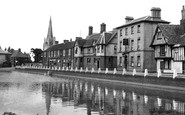
For those taking the waters in Edwardian times, there were plenty of hotels. The most expensive was the Clarendon, with rooms at 6s 6d, breakfast at 3s and dinner at 5s.

Despite the delays in completing the cut, it remained one of the most profitable of England's waterways, paying dividends up to 1947.

In the section of the park beyond Marlborough Road, Edward Davis erected this obelisk to the then Princess Victoria in early 1837 for Bath to commemorate the 'attainment of her majority'.

Back in the days when taking a picture involved a large and unwieldy camera and tripod, a photographer tended to attract a good deal of attention, but at least there appear to be plenty of people

This main street was once part of the Roman road which ran from London to Lewes in West Sussex. The legionaries paved it with ragstone eighteen feet wide and seven inches thick.

Barnwood stands on Ermin Street, which was built by the Romans to link the two important towns of Glevum (Gloucester) and Corinium (Cirencester), so the road we see in this picture

Newerne Street is Lydney's main shopping area; it has undergone a great deal of redevelopment since this photograph was taken.

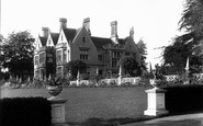
Between the house and the lake we can just see part of the Cremorne Gardens, on the west bank of the mere, which were presented to the townspeople by Lord Brownlow as recently as 1953

It was founded just over 100 years ago thanks to a bequest of £45,496 from a gentleman farmer named Thomas Harper Adams, who died in 1892.
Places (6814)
Photos (9106)
Memories (29054)
Books (11)
Maps (181006)

