Places
3 places found.
Those places high-lighted have photos. All locations may have maps, books and memories.
Photos
63 photos found. Showing results 1,301 to 63.
Maps
12 maps found.
Books
1 books found. Showing results 1,561 to 1.
Memories
7,565 memories found. Showing results 651 to 660.
Growing Up In Newton
I was born in the old cottage on the left, 175 High Street, in 1948, as June Glencross, my parents squatted there after the war, my dad became the local builder. In 1956 we moved up the road to the old congregational ...Read more
A memory of Newton-le-Willows in 1948 by
Good Times
I was born in Hopkinstown and lived in 58 Hopkinstown Road, I will never forget the place, I have been away for a long time but plan to go back soon.
A memory of Hopkinstown in 1950 by
1955 To 57
I spent approx 2 years in Bildeston attending the junior school, headmaster I think his name was Mr Kelk (not sure of spelling). I was fostered from the age of 8 to Bildeston for 2 years. Just before I was 10, I then went back home. I ...Read more
A memory of Bildeston by
Remembering
Hi I was born in Threshfield in 1954. My growing up years were done in Grassington. My Auntie Mary had the Black Horse back then and the chipshop was next door. I went to school in Grassington also and my best friend was Judith Easterby. If anyone knows me please contact me. Yvonne Booth (Dicken)
A memory of Grassington by
Moving To Whitefield
I moved to Whitefield from Birmingham just before my 5th birthday. We went to live on Hill Top Close. We lived at the last house and there was nothing but fields for miles. I went to school on the bus every morning as ...Read more
A memory of Whitefield in 1952 by
1950 1967
I was a 5 year old when we moved into the new housing estate in Northolt, we lived at 31 Rushdene Crescent. Then always it seamed that we had long hot summer holidays, playing in the woods, or in the sand pit (ex army firing range) or ...Read more
A memory of Northolt in 1950 by
Lindsey Cottage And The White House
In 1949 my mother and I moved to Bentworth when my mother became the Health Visitor for Alton. We first stayed at rooms in the White House which was diagonally across from the Dugdales in the Big house at ...Read more
A memory of Bentworth in 1949 by
Ffrith Beach
Oh, the days of endless sunshine, carefree explorations up to the hills above our beloved Ffrith! I was one of the crowd who walked the donkeys and ponies on Ffrith Beach for Mr Pulleine. We walked for MILES during those happy ...Read more
A memory of Prestatyn in 1960
East Barsham Manor 1929 Photograh
The 1929 photograph was taken when my stepfather's father, Douglas J Coleman owned it. His father, Edward J. Coleman, bought it in 1915, the year my stepfather was born. This is where he (Peter ...Read more
A memory of East Barsham by
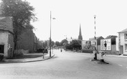
Chelmsford, Shops In The High Streeet, 1919.
This view is taken from outside the island where the current Lloyds Bank stands, and shows the view down the High Street. In the background can be seen the spire, which was the Wesleyan Church, and ...Read more
A memory of Chelmsford by
Captions
2,471 captions found. Showing results 1,561 to 1,584.

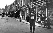
This picture gives us a brief glimpse into the daily life of some of Burnley's people. Notice the woman, right, with the umbrella near the bollard at the top of Saunder Bank.

Here we have a range of hotels for those who could afford the comfort. The Grand was almost brand-new, and the Royal was rebuilding.

To the right of the chapel there are two large chimneys, with others in the distance.

Yet another evocative photograph from the past. Right is the Southdown booking office, with No. 9 the Square accommodating A G Suthers run by electrician 'Cherry' Messam.

The weekly market which dates back centuries is held every Thursday.

This is the most central town in Norfolk. This view shows the varied façades of the buildings fronting the market place. The building next to the King's Arms Hotel on the right is a good example.

The shop extension filled with shoes and boots is now filled with all manner of things for pets. On the other side of the road was a garage, which is now the Job Centre and the Sue Ryder shop.

This marvellously detailed view of the High Street before it was transformed into a pedestrian precinct was taken from the first floor of the Cock Hotel.

The Stanhope Memorial stands in the middle of the space where the market is held twice a week.

However, the number of private cars was increasing all the time, partly thanks to the Coventry Motor Works, centrally situated on the Broadway and dealing with all motorists' needs.

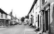
The High Street may look quiet and rural, but five years earlier this street was pounded with traffic day and night.

We are now on the Oxfordshire bank. This is a view looking east, with Nag's Head Island in the middle distance.

The thatched 17th-century King's Head pub still stands on the left, and the re-fronted Red Lion Hotel is still in the centre of the Bull Ring.

We are on the navigable and tidal River Arun. The church of St John the Evangelist has a shingled broach spire; flint and stone are used for walling and buildings.

The hotel façade has not changed, but Boots have moved further along the High Street and the Halifax Bank has replaced Boots.

The name 'Finkle' comes from a Viking word meaning 'angle' or 'corner', and this less than straight street has not changed its line since those times.

On the extreme left is Lloyds Bank, whilst next door is the Stand Up Inn, so called because of the lack of seating - this ensured that any lunchtime customers were not late back to their

We are travelling out of the city towards Manningham Park and on to Shipley and Bingley.

We have taken a 90-degree turn from F106013, and we face the opposite view of the corner of Chapel Lane and Three Tuns Lane.

This street scene has not changed very much except for the names of the occupants.

The modern architecture sits very uncomfortably with the earlier buildings – an example is the Fine Fare building, which now houses Super Drug.

On the third Tuesday in September, the Harpenden Statty Fair (Statute Fair) was held on the common close to the pond and the adjacent Triangle.

Protected from overwhelming traffic by the encirclement of the Upton by-pass to the west and the M53 motorway to the east, Upton has changed little since these views were taken.

The Widnes-Runcorn railway bridge is seen from the West Bank Docks, Widnes.
Places (3)
Photos (63)
Memories (7565)
Books (1)
Maps (12)

