Places
7 places found.
Those places high-lighted have photos. All locations may have maps, books and memories.
Photos
56 photos found. Showing results 241 to 56.
Maps
55 maps found.
Books
Sorry, no books were found that related to your search.
Memories
646 memories found. Showing results 121 to 130.
Two Sisters
About this time my sister would be 7 and I was 9. We used to swim in Sunbury outdoor pool. Never thought of cold or even fear, because one day we crossed weir as the bridge was down - how I was told off by mummy! We lived in Walton and ...Read more
A memory of Sunbury in 1952 by
Police Station
I have only just found this site. I was born in 1944 in Hitchin, Hertfordshire, my Mom was sent there as bombs were falling still in the London area and Woodford was still getting there fair share. We lived in an alleyway ...Read more
A memory of Woodford Bridge in 1947 by
Fishing In The River Weaver...
The scene of hours of fishing in the Weaver under the bridge..My uncle Pete gave me my first rod when I was about 8, it was a 2 part rod made of a tank aerial (I was told!), solid and heavy with no flexibility ...Read more
A memory of Hartford by
Lady Margaret Road
We moved to 108 Lady Margaret Road in 1969. I went to St. Anselms RC school in the Green and then later Southall Grammar (Villiers); my brothers William and Martin went to St. Marks (Hounslow) and Ealing Green then to Dormers. ...Read more
A memory of Heston in 1970 by
Photos Of The House I Grew Up In On Crown Road
My brother Don Quarterman sent me to this web site. What an amazing collection of photographs! So I have to talk about two that show the house we grew up in, Mulberry Cottage. The earlier one ...Read more
A memory of Wheatley in 1953 by
Pontypool Town Centre
I lived in Upper Bridge Street and remember a few of the shops in town, I think! On the corner of Upper Bridge Street and the Bell Pitch was Franketti's fish shop with an awesome Art Nouveau till and free chips if you took ...Read more
A memory of Pontypool in 1960 by
Growing Up With The Dinosaurs.
I lived in Thicket Grove which had the Thicket public house at the top. Crystal Palace Park was a very short walk away. During the school holidays we would spend our days in the park. Mum would pack us a picnic ...Read more
A memory of Crystal Palace in 1953 by
My Childhood Of Old Bracknell Farm
Hi Peter, I remember the Thompkins was it the baker or was that the Cheneys? Joe Smith was the newsagent who used to treat the kids to a summer outing by train every summer. We used to get a new florin and a ...Read more
A memory of Bracknell in 1949 by
Evacuation To Fonab Castle Sept.1939
Evacuation - September 3rd 1939 The government decided that mothers and children should be moved to the countryside away from areas at risk from bombing. On the 3rd, parents and children all gathered at their ...Read more
A memory of Pitlochry in 1930 by
Eccleshill & Greengates In The ''50s
My compliments, Francis. I grew up in Langdale Road, Ravenscliffe 1947-58. Your pictures brought lots of memories back: " the 2penny Rush" - first two rows at Greengates Flicks only cost 2 pennies; cycling along ...Read more
A memory of Greengates in 1949 by
Captions
334 captions found. Showing results 289 to 312.

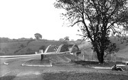
The bus in the distance has just passed Ford Bridge. Once called Stratford (the `street ford`), this was where the Roman road crossed the River Chelmer.

Just up river from the bridge and the castle, this would appear to be a view from Wintour`s Leap of the beginning of the great Horseshoe Bend which encompasses the peninsula of Lancaut.

In the new millennium, it is now time to update the town centre's image by developing high quality, long lasting Visionary Buildings and Open Spaces During the severe flooding in September

There are very few shops along the canal side now. However, there are a couple of pubs still in business, the Ship with the sailing ship pub sign and the Sun with a mounting block outside (centre).
There are very few shops along the canal side now. However, there are a couple of pubs still in business, the Ship with the sailing ship pub sign and the Sun with a mounting block outside (centre).

This view looks south down the High Street from near High Bridge. The 11th-century tower of St Mary le Wigford church peers out amid the later commercial architecture.

This view looks east from Bridge Street, past the Market House and along into Bell Hill.

The High Bridge timber-framed buildings had got into a deplorable state by the 20th century, and were extensively restored and rebuilt in 1900 by William Watkins, who also added the three dormer windows

There are roads along each bank and houses face the river, giving it a slightly Dutch feel. Indeed, there are some fine Georgian houses, particularly on the east side near the good parish church.

Even in the mid-fifties, Edenbridge retained some of its atmosphere as a small agricultural town, strung out along the Roman road which reached out across the Weald from Lewes to London.

Just above the left-hand end of the bridge in S177036 (page 70) and here in 72297 we can see buildings which in the 1920s housed Cooper & Hall, the engineers.
The High Bridge timber-framed buildings had got into a deplorable state by the 20th century, and were extensively restored and rebuilt in 1900 by William Watkins, who also added the three dormer windows

This picture postcard village is strung out along the road, with the River Darent running through it and under the 15th-century humpbacked bridge (seen here behind the horse and cart) alongside a ford

This view shows the Monnow Gate that stands on the bridge of the same name to the left.

The Old Quay Swing Bridge opens by pivoting on the pier on the left hand side of the canal.

The celebrated village of Cookham, a mile or so south of Bourne End, is seen here from the boatyard on the Buckinghamshire bank, although curiously until 1992 a strip of about 30 feet along

This view looks east along West Banks, with its numerous small bridges, to the mainly late Victorian artisan cottages (some are dated 1901).

This view looks along the towpath towards Park Street bridge. The Nestle's factory is just out of sight on the right. The boys are fishing from a miniature wharf which still survives.
Just on the left along Bridge Street was a borehole testing for the coal seam, and it is not surprising that when the lift shaft was being dug for the Argos store on the higher corner that coal should

Sandsend was just three miles along the sandy beach from Whitby.
Sandsend was just three miles along the sandy beach from Whitby.
Sandsend is just three miles along the sandy beach from Whitby.
There are roads along each bank and houses face the river, giving it a slightly Dutch feel. Indeed, there are some fine Georgian houses, particularly on the east side near the good parish church.
This picture postcard village is strung out along the road, with the River Darent running through it and under the 15th-century humpbacked bridge (seen here behind the horse and cart) alongside a ford
Places (7)
Photos (56)
Memories (646)
Books (0)
Maps (55)

