Places
26 places found.
Those places high-lighted have photos. All locations may have maps, books and memories.
- Cemmaes Road, Powys
- Six Road Ends, County Down
- Road Weedon, Northamptonshire
- Severn Road Bridge, Gloucestershire
- Roade, Northamptonshire
- Berkeley Road, Gloucestershire
- Harling Road, Norfolk
- Road Green, Devon
- Builth Road, Powys
- Cross Roads, Yorkshire
- Steele Road, Borders
- Cross Roads, Devon
- Four Roads, Dyfed
- Road Green, Norfolk
- Biggar Road, Strathclyde
- Clarbeston Road, Dyfed
- Five Roads, Dyfed
- Eccles Road, Norfolk
- Grampound Road, Cornwall
- Morchard Road, Devon
- Wood Road, Greater Manchester
- Four Roads, Isle of Man
- St Columb Road, Cornwall
- Clipiau, Gwynedd (near Cemmaes Road)
- New Road Side, Yorkshire (near Silsden)
- New Road Side, Yorkshire (near Cleckheaton)
Photos
14,329 photos found. Showing results 2,701 to 2,720.


Maps
476 maps found.
Books
5 books found. Showing results 3,241 to 5.
Memories
11,058 memories found. Showing results 1,351 to 1,360.
East Front Road In The Sixties
My Grandparents, George and Ella Ashford, had retired to Pagham in 1958. They lived at number 12 East Front Road. Their bungalow was very comfortable with a great view out over the channel. The original railway ...Read more
A memory of Pagham by
My Three Years At Reedham
I recall walking past the gate-house with my mother on a Tuesday afternoon in March 1950. I was to start my lustrous career there for a period of three years, leaving in March 1953. Starting there was an real shock to the ...Read more
A memory of Purley in 1950 by
Running On The Common 1980s
During the '80s I lived in Streathbourne Road, just a couple of houses in from the Common. Weather permitting I would run in the evenings. One dark evening in the late autumn I ventured onto the Common. ...Read more
A memory of Tooting Bec Common by
Harrison Gibbisons Fire
Though this picture is dated 1955, I think its actually later than this. The reason for this is that about 1960 the Harrison Gibbison shop had a big fire that not only destroyed that shop but also Selfridges next door. This ...Read more
A memory of Ilford in 1960 by
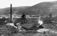
Afan Colliery
This is the old afan colliery in full swing until the late 60's early 70's. This picture was taken from the Bwlch Road looking over Jersey Road. The lone white building is the old vicarage.
A memory of Blaengwynfi in 1968 by
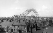
Building The Bridge
I was sat in my classroom at the parish school in church street and I had just put away my plastic counters after a hard maths lesson ,I was only 5 ( and 1+1 was very hard)my teachers name was mrs oats she was lovely and as I ...Read more
A memory of Runcorn in 1961 by
Mytchett Road
My aunt and uncle used to own a large old house in Mytchett Rd. It had a long driveway leading down to an orchard and fields, where my cousins and I would spend many happy hours. In one field was a large pond with a willow tree on ...Read more
A memory of Mytchett in 1957 by
The Howard Family Of Barnes And Hammersmith
My Great-Great-Grandad, Henry Howard, lived in the early 1800’s - a time of great rural depression - and so he left his Devon home to look for work in London with the result that several generations of my ...Read more
A memory of Barnes in 1870 by
Boyhood Memories Of Peperharrow Road.
It was the summer of 1946 and we used to go swimming in the river at a spot called "The Ginny" which was up the road a little (towards the camera) on the opposite side of the road to these houses. This part ...Read more
A memory of Godalming in 1946 by
Born Here In 1947
I was born around the corner from the photo, at 15 Eastcote Lane, just off the Northolt Road, in 1947 (born at home, too, not in a hospital!) Remember going to school on Northolt Road, maybe a quarter mile west of the ...Read more
A memory of South Harrow in 1954 by
Your search returned a large number of results. Please try to refine your search further.
Captions
5,036 captions found. Showing results 3,241 to 3,264.

We have moved further west to the junction with St Ives Road, looking east. The Bear Hotel on the left has an early 19th-century stucco front; further on are the Chapel Arches.

Reflecting the town's original location on that highway beloved of cyclists, the Great North Road, the sign to the rear of the memorial promises 'Cycles Stored and Repaired'.

On the opposite side of the road was the Onslow Arms inn, whose name honours the Onslow family.

On the right are some of the new detached houses which backed onto the railway at the start of Upper Mulgrave Road.

A workman digging a hole in the road attracts the attention of mothers who pause with their prams. The timber-framed building close to the bridge is known as the Old Siege House.

Further up the road is the Victorian parish church, which replaced one of 1791 which itself replaced the medieval one, apparently burned down in the Civil War.

East of Lincoln, Wragby is a market town on the Horncastle and Skegness road which is very busy at weekends and in summer.

It is regrettable that the Pavilion is clearly visible from London Road as one arrives from the south, and it may be that a tree screen could be considered helpful.

The picturesque village is situated on a minor east-west road, rising up from the reservoir past Sir James Pennethorne's hall, which took some twenty years to complete, the medieval parish church and

The village shop and post office in the distance beyond the children still functions, but the shop-like Gilling Club (to the left of the woman in the middle of the road) has become a house

Castle Road (part of the A360 to Amesbury) is on the right, and the Avon Valley is just out of the picture to the left.

This was such a tranquil place in 1906; but now it lies on the main Dales road from Hawes to Leyburn.

The parish church, St Michael's, with its fine octagonal tower, occupies the north side of the Market Place, which is effectively bisected by the through road to Frome.

The pavement, the flowerbed and some of the road represent the location of buildings demolished in 1938 that hid the old school and St John's Hospital buildings from public view.

Virtually all of the buildings in this photograph have been replaced; today the Orchards Shopping Centre is on the left, whilst on the opposite side of the road are currently Barclays Bank

Beeson's, on the left, is still flourishing in 1903 but was rebuit in the 1990s in approximate facsimile as offices named Talbot House, re-using the 'Talbot Road 1863' stone plaque street name.

The view shows the centre of Domesday Anstige, as the road drops down from the heights of Bradgate Park.

The Turkey Cock c1965 This village watering hole on the road to neighbouring Widford prided itself on being 'the world's most exclusive pub', as evidenced by the signs proclaiming 'No teenager

The Old Bank building, which stood at the junction of Chertsey Road, High Street and Broadway, failed to survive the post Second World War swathe of redevelopment which saw many of the town's Victorian

Stolid Victorian shops and houses stood here alongside the main A25 road linking Guildford and Dorking.

The Curzon Cinema, on the left, opened its doors for business in 1911 as the Cheam Road Cinema.

The 1821 chapel, the hipped pantile-roofed building further along the road, itself survives.

The first of the road traffic tunnels to be dug under the River Mersey, the Queensway Tunnel was opened by King George V and Queen Mary on 18 July 1934.

Positioned alongside the old course of the Great North Road, the unusual and impressive 'Bottle Lodges' at the entrance to Burghley Park must have been a familiar sight to travellers approaching Stamford
Places (26)
Photos (14329)
Memories (11058)
Books (5)
Maps (476)

