Places
36 places found.
Those places high-lighted have photos. All locations may have maps, books and memories.
- Bangor, County Down
- Newcastle, County Down
- Greyabbey, County Down
- Donaghadee, County Down
- Downpatrick, County Down
- Portaferry, County Down
- Dromore, County Down
- Downings, Republic of Ireland
- Hillsborough, County Down
- Killyleagh, County Down
- Ardglass, County Down
- Rostrevor, County Down
- Dundrum, County Down
- Newtownards, County Down
- Warrenpoint, County Down
- Ballygowan, County Down
- Ballywalter, County Down
- Ballyward, County Down
- Bishops Court, County Down
- Boardmills, County Down
- Culcavy, County Down
- Katesbridge, County Down
- Killough, County Down
- Millisle, County Down
- Portavogie, County Down
- Saul, County Down
- Seaforde, County Down
- The Diamond, County Down
- Audleystown, County Down
- Kearney, County Down
- Annaclone, County Down
- Ballyhalbert, County Down
- Ballymartin, County Down
- Clare, County Down
- Conlig, County Down
- Dollingstown, County Down
Photos
1,089 photos found. Showing results 681 to 700.


Maps
459 maps found.
Books
47 books found. Showing results 817 to 840.
Memories
8,147 memories found. Showing results 341 to 350.
Early Memories
One of my earliest memories was the Coronation. In Northfield Road there was a dairy that opened up its premises for a street party. We used to go to the railway bridge off Burgess Road to watch the steam trains. I had forgotten ...Read more
A memory of East Ham in 1953
Land Army Memories.
The white weatherboarded house was the farmhouse of the farm where my mother, Joyce Clark, worked along with another 3 girls in the Land Army during the Second World War. It was called Cogger's Farm. She was there whilst the ...Read more
A memory of Lamberhurst by
Fondest Memories Of Gt Oakley 1938 To 1961
That was when I was born along with a bunch of other kids who grew up with me and with whom I played during the WW2 years and eventually went to C of E school together. Mr Porter was a teacher there, ...Read more
A memory of Great Oakley by
My Banbury Grans Village
My grandmother's name was Amelia Gough and she lived in the second cottage on the right at the bottom of the green on the road to Mollington. Water was collected by bucket over the road from a tap in the vicarage wall. ...Read more
A memory of Warmington in 1940 by
Mum With Kids
The lady in the foreground looks very like my mum with me walking to her left and my sister in the pushchair. We lived locally and went to the beach all the time. It would be interesting to see that part enlarged so I could identify ...Read more
A memory of Newhaven in 1965 by
Victory Parade And The Sudden Downpour
What memories this picture brings back to life again!! I had just been discharged from the Fever Hospital having spent six weeks there with Scarlet Fever. Nothing was going to stop me from taking part in the ...Read more
A memory of Pitsea by
National Service
I know I was doing my bit for my country at the time, but Medmenham will always be in my memory because of the great friends I made at the RAF station. It was also a beautiful part of the country to be doing my service. I got to ...Read more
A memory of Medmenham in 1956 by
My Family
My father's family moved to Harwich in the early 1900's to cottages below Upper Dovercourt Church and lived there for many years. I was born in 1950 when my parents lived in Ramsey then we moved to Valley Road. I still have family in the ...Read more
A memory of Harwich by
Visiting Pontllyfni
I spent two wonderful summers in Pontllyfni in 1974 and 1976. I was a college student from the U.S., visiting Wales with a friend who had a cousin living there. The family owned a small inn just up the road from the beach. ...Read more
A memory of Pontllyfni in 1974 by
Greenham's The Butchers & Brewer's The Grocers
In 1954, as a 17 year old cashier bookkeeper, I started work for Mr Greenham, whose butcher's shop was near the top of Broad Street. Some years later (in 1958), I went to work at Brewer's, the ...Read more
A memory of Lyme Regis in 1954 by
Captions
2,258 captions found. Showing results 817 to 840.

This photograph appears to show a quiet village where nothing much happens apart from an amble down to the post office to buy a few stamps.

The High Street becomes Fore Street as it heads down towards the river Exe. The street today is a mass of shops and attractive buildings, none more so than Tuckers Hall.

Later, they fell victim both to progress and anti-pollution legislation, and were replaced by gas-fired and electric kilns.The last of the bottle kilns to be used commercially closed down in 1967

The summit at 1083 feet is at the head of West Down at the southern point of Cleeve Common.

This solidly-built Edwardian shop is still trading as the Post Office, despite some alteration; it stands on the way down to the former station site.

To the right, there is still a fish and chip shop by West Street, which runs down to the Minster.

The large, stone building down Quietways, on the right, was the vicarage.

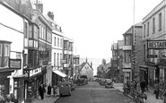
The railway is now behind the photographer, who is looking down High Street at the height of its Victorian expansion with the street dominated by tall telegraph poles.

The Belfast and County Down Railway used their Slieve Bearnagh trips to Portrush or Portaferry with cruises up Strangford Lough.

Further down on the right was the Phoenix, the scene of Hardy's poem 'The Dance at the Phoenix'.

Here we see a barge loaded down with hay, with the two horses taking a break as the photographer creates his picture.

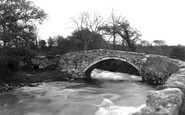
Stickle Ghyll, which flows down from Stickle Tarn, passes under the bridge in this photograph, which was taken looking towards the 2,403ft summit of Harrison Stickle, the highest of the pikes.

It was winded by hand by means of an endless chain which hung from a chainwheel at the rear of the cap down to the ground.

A pleasure steamer, the 'Queen of the Broads', crowded with tourists and well equipped with life belts, ploughs her way round the wide bend of the river Bure and down towards the sea.

Now all of that has changed, and so has Bridge Street, for it has virtually all been knocked down for redevelopment. On the left is now either cleared or a car park, and the road is much wider.

For centuries, lines of horses would lumber over this bridge weighed down with freight. Often, lead would be the main load.

The church of St Mary was burnt down in 1914 and rebuilt by W Fellowes Prynne. What remained of the old building was the brick west tower dating back to around 1635.

During the Protectorate in the 17th century, the cathedral was in danger of being pulled down.

This photograph, probably taken from the top of St Mary Woolnoth Church, shows the view west down Poultry which leads directly into Cheapside.

In 1796 the old tower was pulled down and a new one built, and in 1808 the main body of the church was demolished and rebuilt at a cost of £842.

As we look at this mundane street as it drops down towards Pinner Underground Station, under the railway bridge and on towards Harrow-on-the-Hill, there is little to herald the wonderful surprise of turning

The shop in the right foreground is now Mark Doel's butcher's shop; the modern library is a few doors further down towards the Angel, whose sign can be seen in the distance.

On the right is a tent and small wind shelters, while further along is a solitary bathing machine, which appears never to have been moved down to the sea.

Further down, on the pavement, is the town`s pump.
Places (198)
Photos (1089)
Memories (8147)
Books (47)
Maps (459)

