Places
Sorry, no places were found that related to your search.
Photos
Sorry, no photos were found that related to your search.
Maps
Sorry, no maps were found that related to your search.
Books
Sorry, no books were found that related to your search.
Memories
3,644 memories found. Showing results 381 to 390.
Growing Up In Woolton
My family from many generations back have liven in Woolton and Gateacre. I grew up in a house opposite the English Rose pub and went to Out Lane primary school. We spent our summer days playing in the orchard by Watergate ...Read more
A memory of Woolton by
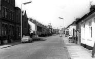
Durell Road, Martins Corner
What a place! If you're not born here, run for the hills! But I love it, I still see faces of long ago that do too, or why didn't we move away a long time ago!! My mum and dad were the best, I never got hit by them but ...Read more
A memory of Barking in 1970 by
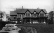
T Axel Convelescent Home
According to what I have found out, this home was run in my day by two ex service men, one of them being married. There was a German female cook who made the top of rice pudding with a sheet of toffee on the top.
A memory of Taxal
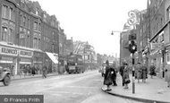
Victoria Road.
Where the advertising boards are, there was a barber shop run by a lovely man called Alf Bernadi. I would take my little brother to have his hair cut & sit and read him the Beano comics while we were waiting. I'm almost sure ...Read more
A memory of Aldershot in 1959 by
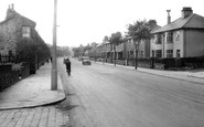
Stacksteads Boyhood.
My family moved from Haslingden to Newchurch Road in 1950 opposite the Farhome Tavern. As an eight year old I attended Western Junior School until 1953 leaving to attend Blackthorn Secondary Modern until June 1957 when our ...Read more
A memory of Stacksteads in 1950 by
Tin Tan Tommy
I moved to the hill as a child with my brother and sisters in the early 1950as to Dagnam Park Square. We had a lovely wood there to play in. Tin Tan Tommy was our best game, standing on the sand bin spying out the other kids and ...Read more
A memory of Harold Hill in 1956 by
A Yokels Tale
A Personal Recollection of growing up during the last days of the pedestrian era in rural England by Tom Thornton A Yokel's Tale My earliest recollection of my Thornton grandparents, Alice and Tom, dates back to my pre-school ...Read more
A memory of Owslebury in 1941 by
Childhod Memories.
I visited Eagle Hall as a child, my grandfather, Mr GB Edward, and his wife bought the Hall in a fairly run down condition. I have memories of horse riding around the grounds swimming in one of the lakes, and of how ...Read more
A memory of Pateley Bridge in 1965 by
Chingford Hatch
I remember the Manor pub, it used to have an air raid warning siren on the building. I remember hearing it once, testing it I think as the year was about 1956. I too remember the tea van which had an awning on it in the rain. As ...Read more
A memory of Chingford in 1956 by

Caerphilly
I used to live in Bartlett Street next to the bus station. My first job in Caerphilly was as a delivery driver for Harris & Ash DIY merchants, they were situated in a double fronted shop opposite the castle, although I came ...Read more
A memory of Caerphilly in 1966 by
Captions
1,151 captions found. Showing results 913 to 936.

The name of this lane, which runs north from the junction of High Street and Lewes Road, refers to Sackville College.

The next views are of the residential roads laid out to the east of Brighton Road.

Of interest here is the single-hold steam coaster, one of hundreds of such vessels in the 90ft to 140ft range, which were capable of carrying up to about 300 tons of cargo into the smallest of harbours

This canal was constructed in 1796; it runs for nearly forty miles through northern Hampshire.

At first it was suggested that the railway station should be built adjacent to St Martin's Church in 'The Lordship' (see picture 53332A on pages 48-49), now known as Meadow Bank Recreation Ground

The white-painted single-storey building in the middle of the row of shops originally had a thatched roof and was Irby's only shop, doubling also as the village post office.

This town is often over-run by pilgrims and tourists, but the local inhabitants still require basic essentials, even coal (left) and petrol for their vehicles (right).

This former slate-mining village lies below Cadair Idris, cupped in the Dysynni valley between Tal-y-Llyn and Tywyn.

The High Street runs parallel to the north wall of the Abbey precinct and has a good range of Georgian and early 19th-century two- and three-storey houses.

By 1821 the population of the parish was over 7,000. The Reverend James Dixon was the vicar and Matthew Spilling the local surgeon, while his wife Ann ran a ladies' boarding school.

This broad parade, named after Queen Victoria, runs along the East Cliff in front of Wellington Crescent and the lawns.

This stone, which marked the grave of a Viking warrior, was his resting spot for over 1,000 years: it is from the 10th century.

The Drapery runs parallel to the west side of the Market Place, and was once known as the Glovery. This view was taken from the south beside All Saints' Church.

This is the same scene as photograph No 37890 in the opposite direction, four years later, revealing the rich assortment of buildings and businesses which had developed along this stretch of the main

By the date this picture was taken, Doncaster had been a racing centre for nearly three hundred years and had been the home of the oldest classic race, the St Leger, since its first running in 1778

Here we see motorists in the village - they are probably touring the area. The 'burn' part of the name comes from the stream which runs through the village.

The abbey stands on the site of a Saxon nunnery set up by Domneva, and run by St Augustine's monks from Canterbury; it was destroyed in the ninth century by the invading Danes.

One of the first buildings that the visitor will meet is the picturesque 15th-century thatched Axe and Compasses public house (centre).

This stream, the Lode Pit Beck, flows off the moor into the Aire at Shipley. A former drovers' track took trade over the hills to Ilkley and Otley.

South of Ollerton is Rufford Country Park, run by the County Council.
The Fraternity of the Holy Cross built the two bridges, the causeway across Nag's Head Island, and then the long causeway that runs south for over a thousand yards across the flood plain to Culham

Nine Mile Ride runs east to west from south Easthampstead to south of the Arborfield Garrison, originally cutting through Windsor Forest; it is now developed with long lines of bungalows.

Lying in the north west of the county, Mildenhall boasts one of the most magnificent churches in the region.

Children pose near the small bridge over Downham Beck, a brook which runs through the heart of the village.
Places (0)
Photos (0)
Memories (3644)
Books (0)
Maps (0)

