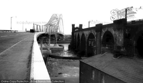
Widnes, Runcorn Widnes Bridge c.1961
Photo ref:
W97026


More about this scene
Below the bridges we can see the River Mersey, which was the former county boundary. At this point the river crossing narrows to form the Runcorn Gap, so that there was a ferry here from medieval times. Compared to the new road bridge (left) the railway bridge on the right seems so clumsy – its foundations had to be built under the water, and go down some 45 feet below the low-water mark.
Add to Album
You must be signed in to save to an album
Sign inShare This Photo
Buy a Print
Unframed, Mounted, Framed and Canvas prints in a range of sizes and styles.
View Sizes & Prices
A Selection of Memories from Widnes
For many years now, we've been inviting visitors to our website to add their own memories to share their experiences of life as it was, prompted by the photographs in our archive. Here are some from Widnes
Sparked a Memory for you?
If this has sparked a memory, why not share it here?







 Before
 After
After