Places
17 places found.
Those places high-lighted have photos. All locations may have maps, books and memories.
- Bridge End, Oxfordshire
- Bridge End, Lincolnshire
- Bridge End, Essex
- Bridge End, Bedfordshire
- Bridge End, Clwyd
- Bridge End, Warwickshire
- Bridge End, Surrey
- Bridge End, Durham (near Frosterley)
- Bridge End, Northumberland (near Hexham)
- Bridge End, Hereford & Worcester (near Tirley)
- Bridge End, Hereford & Worcester (near Bosbury)
- Bridge End, Shetland Islands
- Bridge End, Cumbria (near Carlisle)
- Bridge End, Northumberland (near Hexham)
- Bridge End, Devon (near Kingsbridge)
- Bridge End, Devon (near Sidmouth)
- West End, Yorkshire (near Pateley Bridge)
Photos
40 photos found. Showing results 121 to 40.
Maps
520 maps found.


Books
2 books found. Showing results 145 to 2.
Memories
1,928 memories found. Showing results 61 to 70.
Growing Up In Greenford In The 1960s And 1970s
Here are some random memories: Lists Bakeries on Greenford Broadway. Lovely aroma, tasty bread. The paper bags all used to have the slogan 'Good Flavour Always Finds Favour'. The covered market ...Read more
A memory of Greenford by
Cheadle In The Second World War
I think that we must have moved to Cheadle around 1938, because I was born in Newcastle under Lyme, but my younger sister was born in Cheadle in 1939. At that time we lived on Leek Road. We had various ...Read more
A memory of Cheadle in 1930 by
Bombing Raids In 1940
Bristol's premier shopping centre was turned into a wasteland of burned out buildings after major bombing raids in 1940, during the Second World War. Bridge Street Summary Bridge Street ran from High Street, rising up a ...Read more
A memory of Bristol by
Tales Of College Green
This shows College Green and its grand posh upmarket shops, at a time in the past when parking wasn't a problem. Many famous people lived round the Green over the years including Mary Robinson; actress and mistress of the ...Read more
A memory of Bristol by
The Dry Ponds
As a lad I can remember walking with `our gang` across from the High Street side of the ponds, under North Street bridge & walking out under the chain on the West Street end on the other side of the war memorial. We went there ...Read more
A memory of Carshalton in 1940 by
Aston Terrace
I was born in Aston Terrace in 1954 and remember running to the bridge to see the steam trains and also the big slag heap that my brothers used to slide down. I also remember the gas man that used to light the street gas lamps outside ...Read more
A memory of Aston in 1954
Machen Trethomas Bedwas 1960
Hello Diane, How are you?I was born and brought up in Machen, 1 Brynhyfryd Terrace. Moved to Trethomas after marriage, lived in Lower Glyn Gwyn (1954) .The Glue Pot you talk about was the Lewis's Hotel (pub), do you ...Read more
A memory of Machen by
Memories Of Traffic Control
I read the letter from someone who remembers the policeman in the top floor of a shop overlooking the Bridge at Christmas. Well that policeman was Gordon (Sandy) Lewis - a cheeky chappie, who gave everyone a smile when ...Read more
A memory of Walsall in 1963 by
Growing Up In Woodford
Growing up during war years and having to spend many nights in the Anderson shelter at bottom of garden. School was only half days for a while and when my brother started he had to go to neighbouring houses where ...Read more
A memory of Woodford Green in 1940 by
Lady Margaret Road
We moved to 108 Lady Margaret Road in 1969. I went to St. Anselms RC school in the Green and then later Southall Grammar (Villiers); my brothers William and Martin went to St. Marks (Hounslow) and Ealing Green then to Dormers. ...Read more
A memory of Heston in 1970 by
Captions
1,770 captions found. Showing results 145 to 168.

We can see a tower of Stephenson's 412ft-long tubular railway bridge in the centre of the picture. This structure was built on the line of the old L & NWR Railway in 1848.

De Vaux Place 1928 On the Salisbury side of Harnham Bridge, De Vaux Place leads to The Close - the Harnham Gate is at the far end of the wall.

Stevens's Boatyard on the east end of Nag's Head Island also incorporated the landing stage for the Crown and Thistle Hotel in Bridge Street, some hundred yards away from the river.

Its 15th- century gateway survives at the end of the short lane with St Nicholas's Church on the left, where monastic workers, market traders and travellers could worship.

A mile and a half north-east of Daventry, the Grand Junction (formerly the Grand Union) Canal cuts through the limestone ridge via the Braunston Tunnel.

The Swan Hotel acquired a multi-level car park to its rear (its first concession to the age of the motor car) and the erstwhile car showrooms at the northern end of Town Bridge were demolished and replaced

Here Frith's photographer was looking from the east end of Scott's 1864 bridge towards the ridge descending to the flatter land of Burcott and Berinsfield; the east part of the village

Built to link the Promenade to the attractions of Princes Park, the doubly-named bridge rests on two artificial islands in the Marine Lake.

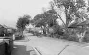
We are looking east towards the bridge over the beck. The village is only two miles from Richmond, but it retains its rural charm.

The High Street turns north, and it and the town end abruptly at the River Great Ouse, which flows through meadows liable to flooding.

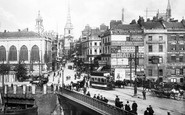
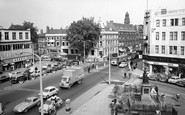
Several sets of traffic lights control the flow of vehicles now, and it is rare to find a queue such as this.

This is East Bridge, at the eastern end of East Street (far right), looking eastwards from the north bank of the River Asker.
We are looking east towards the bridge over the beck. The village is only two miles from Richmond, but it retains its rural charm.
This is East Bridge, at the eastern end of East Street (far right), looking eastwards from the north bank of the River Asker.

In the 1920s, Tom Richmond's West End Boating Stage offered rowing, Canadian-style skiffs and punts. A motor boat plied between here and Collingham Bridge.

The village of Muker, set toward the western end of the dale, dates back to 1274. After a chapel of ease was built here in 1580, the delightfully named Corpse Way gradually fell into disuse.

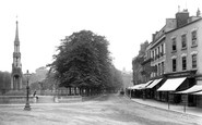
We are looking at West Bank and the Victoria Promenade. This area had been regarded as a holiday resort, and had been known as Wood-end 150 years before.
The village of Muker, set toward the western end of the dale, dates back to 1274. After a chapel of ease was built here in 1580, the delightfully named Corpse Way gradually fell into disuse.

Originally the first of the Cinque Ports, its Saxon harbour had silted up by the late 14th century, ending its role as the chief place of embarkation for the Continent and as England's premier naval
Originally the first of the Cinque Ports, its Saxon harbour had silted up by the late 14th century, ending its role as the chief place of embarkation for the Continent and as England's premier naval

The name of the village had an 'e' on the end until the railway company put up their sign spelt 'Gisburn', and the 'e' was forgotten. Here we see the main street.

The bridge itself fell into disrepair; in 1931 it was closed to vehicular traffic, although people could continue to walk across it if they paid their penny.

East Bridge, at the eastern end of East Street (left), was built by J and T Gale in 1784 and has been widened.

These views show each end of the bridge - two were taken in 1890.
Places (17)
Photos (40)
Memories (1928)
Books (2)
Maps (520)

