Places
17 places found.
Those places high-lighted have photos. All locations may have maps, books and memories.
- Bridge End, Oxfordshire
- Bridge End, Lincolnshire
- Bridge End, Essex
- Bridge End, Bedfordshire
- Bridge End, Clwyd
- Bridge End, Warwickshire
- Bridge End, Surrey
- Bridge End, Durham (near Frosterley)
- Bridge End, Northumberland (near Hexham)
- Bridge End, Hereford & Worcester (near Tirley)
- Bridge End, Hereford & Worcester (near Bosbury)
- Bridge End, Shetland Islands
- Bridge End, Cumbria (near Carlisle)
- Bridge End, Northumberland (near Hexham)
- Bridge End, Devon (near Kingsbridge)
- Bridge End, Devon (near Sidmouth)
- West End, Yorkshire (near Pateley Bridge)
Photos
40 photos found. Showing results 301 to 40.
Maps
520 maps found.


Books
2 books found. Showing results 361 to 2.
Memories
1,925 memories found. Showing results 151 to 160.
Early Years At Medge
I spent my first seven years at Medge Hall, and have fond memories of growing up with my brother Phillip, and baby sister Sheryl. We lived in Crook-a-Moor cottages (the 2nd house from the bridge) until around 1970. My ...Read more
A memory of Medge Hall in 1967 by
Horfield Old Boys
Does any one remember me? My name is Robert Cox. I lived at 47 Sheridan Road right next to the lane that went down to the tip (now built on). I went to Upper Horfield School and I still remember my first day at the school in ...Read more
A memory of Horfield in 1967 by
Things We Did As Kids
I remember playing in the park, opposite my house in Waun Fawr. Thats as far as I was allowed to go until I learnt how to fool my parents, then it was up to the Blue Lake or the Waun-y-pound usually as we were skipping ...Read more
A memory of Rassau in 1967 by
Scary
Who remembers running along the two boards inside the bridge and jumping between the gaps. Scary or what, or did you not live dangerously like me and Tom Eastlake?
A memory of Ashington in 1967 by
Will It Be Open?
My family moved from Bermondsey, where we shared my grandad's house, to Enfield, where Mum and Dad had managed to buy their own house (for £2,000) in 1960. It was some years before Dad could afford driving lessons and then a car. We ...Read more
A memory of London in 1966 by
Wonderful Memories Growing Up In Bassaleg
I lived in Bassaleg from the age of 3, (1955), when Church Crescent and surrounding area was being developed. I lived in Church Crescent with my family until I left for Manchester in 1976. I went to the ...Read more
A memory of Bassaleg in 1966 by
Market Days
I remember the various market stalls well, and the market cafe where you could be a greasy bacon cob, and a well stewed tea from the giant tea pot ! I used to buy a bundle of nylon stockings from a stall on the town hall corner. There ...Read more
A memory of Worksop in 1966 by
Hanging Over
I remember being hung over this bridge by my ankles. Not one of my better moments and I'm sure if the two lads that did it read this, they will know who they are without me having to mention their names! We had some happy times together, our gang.Those were the days.
A memory of Great Haywood in 1966 by
Born And Bred
I was born in Great Bridge when it was a thriving centre. One could get absolutely anything there, from wet fish, tailored suits to model aeroplanes! I attended Tipton Grammar School, from 1962 to 67- which I hated. I remember a ...Read more
A memory of Tipton in 1966
Speed
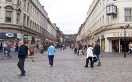
In relation to Reform Street and the city square on Friday/Saturday nights. We boys and our latest girlfriends (only if you had a car) used to meet and have a drag race either up Reform Street and back or a race from city square out under the ...Read more
A memory of Dundee in 1966 by
Captions
1,770 captions found. Showing results 361 to 384.

The bridge was constructed to give road access to the railway station built on the St Martin's side of the river in 1846; it was designed in the same Gothic Revival architectural style, and the parapet

Tilford is situated where the south branch of the River Wey meets the main River Wey, each branch crossed by a medieval bridge.

The Whitchurch Tollbridge Company was established in the 18th century: a distinctive Victorian bridge of lattice ironwork spans the Thames between Whitchurch and Pangbourne, one of only two remaining toll

The 'longest and fairest' bridge in Cornwall crosses the upper part of the Camel estuary, seen here at high tide.
The Fraternity of the Holy Cross built the two bridges, the causeway across Nag's Head Island, and then the long causeway that runs south for over a thousand yards across the flood plain to Culham

Cock Bridge takes Whalley Road across the River Calder (now much cleaner than it used to be) and links Great Harwood and Whalley.

High Sweden Bridge is a picturesque packhorse bridge over the Scandale Beck between High Pike and Snarker Pike (there is a Low Sweden Bridge lower down the valley).
Here we see St John's College Old Bridge, originally conceived by Wren, but brought into being in 1712 by Robert Grumbold.

The bridge was built by the Bishop of Salisbury around 1240 to facilitate trade between the new city and the south: the Cathedral spire can be seen in the background.

Having Avenham Park in the background does enhance the pleasure of a walk over the bridge. Avenham Tower can be seen in the trees to the right, and the paths lead away to Frenchwood.

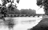
The seven-arched bridge is made from sandstone. It was designed by John Gwynne, a founder member of the Royal Academy, and constructed in 1771.
High Sweden Bridge is a picturesque packhorse bridge over the Scandale Beck between High Pike and Snarker Pike (there is a Low Sweden Bridge further down the valley).

Stopham Bridge has long been considered one of the finest and most striking of medieval bridges in the country. Dating back to 1309 and rebuilt in 1403, the bridge is now preserved.

The bridge was not always as level, strong and wide as this.

The halfpenny toll on the original Blackfriars Bridge caused riots, and in 1780 angry protesters burned down the toll-house.After a succession of expensive repairs a replacement was suggested, and

This bridge, like the one at Bewdley, was designed by Thomas Telford; it replaced an old ferry and ford. It is a single-span iron bridge.

This was the latest of many wooden bridges to span the River Stour at this point on the main route from Essex (right) into Suffolk.
High Sweden Bridge is a picturesque packhorse bridge over the Scandale Beck between High Pike and Snarker Pike (there is a Low Sweden Bridge lower down the valley).

Teddington was earlier called Todynton and Tuddington.

In 1852 a suspension bridge was built over the Dee to link the suburb of Queen's Park with the Groves on the north side of the river. In the distance can be seen the mills and the Old Dee Bridge.
 c.1965, Warrington")
Known locally as 'The Cantilever', this high level fixed bridge provides a welcome escape route when the Knutsford and London Road swing bridges are closed.

Having Avenham Park in the background does enhance the pleasure of a walk over the bridge. Avenham Tower can be seen in the trees to the right, and the paths lead away to Frenchwood.

Thomas Telford's stately bridge over the Severn was completed in 1801, a delightful mixture of stone and cast iron.

The Bridge House Hotel, seen to the left of the bridge, claimed that it was the only top class hotel in Eton. It was demolished in 1964 and a new restaurant has taken its place.
Places (17)
Photos (40)
Memories (1925)
Books (2)
Maps (520)

