Places
Sorry, no places were found that related to your search.
Photos
134 photos found. Showing results 581 to 134.
Maps
896 maps found.


Books
3 books found. Showing results 697 to 3.
Memories
540 memories found. Showing results 291 to 300.
Lower Broughton
I remember so well every Saturday going with my Mum down Lower Broughton Rd to do the shopping. We used to live on Elton Street which was across from Lower Broughton Road at one end. My Grandparents lived on Edward Street. There ...Read more
A memory of Salford in 1961 by
Lovely Memories Of Godstone
My Mum and Gran came to Godstone with me as a baby, we moved from Croydon because of the Second World War. My granddad, Alfred Sreatfield, now dead, had helped to build 13 Salisbury Road. I was christened at St ...Read more
A memory of Godstone in 1944 by
Lovely Days
Like many others I also spent summer holidays in Birchington with my Grandfather at 96, Park Avenue. I remember that the Icecream Parlour had a fairly large wooden parrot outside. We were friends with the children opposite at 111, ...Read more
A memory of Birchington by
Lovely Stoke Fleming
We stayed at a clifftop house called Mill Meadow. Once we parked the car behind the wooden double gates, there was a pine-tree lined steep hill that led to the house and then to cliffs. I remember that pine smell when we ...Read more
A memory of Stoke Fleming in 1967 by
Lost Village Of East Holywell
I was born in East Holywell in 1946 and lived at 24 North Row. By then there were only 2 rows of houses left. We lived with my grandmother, Eva Barnfather, who had been there since the turn of the century. Like ...Read more
A memory of East Holywell in 1950 by
Lost At Sea
I spent many of my younger years in the 60s at Ladram bay . One particular afternoonI took out a small Dingey with a Dutch friend and we did not arrive back until dark Only to see many lights on the beach we jumped out of the Dingey and ...Read more
A memory of Ladram Bay by
Looking Westwards, Towards Thorpe Hall Boulevard Junction With The Esplanade.
In 2014, across the road there are tennis courts, and from Google Earth it looks like a thriving Sports Centre. If there were tennis courts on that site in 1963, hardly ...Read more
A memory of Thorpe Bay by
Looking Westwards, Towards Thorpe Hall Boulevard Junction With The Esplanade.
In 2014, across the road there are tennis courts, and from Google Earth it looks like a thriving Sports Centre. If there were tennis courts on that site in 1963, hardly ...Read more
A memory of Thorpe Bay by
Looking For Jean Laverick Maiden Name
Does anyone know of Jean Laverick and her two sisters (Margaret and Anne) who lived in Holystone, Whitley Bay in the late 1940s? We were the NZ family who lived down the road and we played and went to ...Read more
A memory of Holystone in 1949 by
Long Summer Holidays In The 50's.
My grandparents had bought No 64, Castle Drive (now 156) in the mid 30's. After the war ended they moved down to the Bay until they passed away in the 1980's. Each summer school holidays meant I had 4 glorious ...Read more
A memory of Pevensey Bay in 1956 by
Captions
870 captions found. Showing results 697 to 720.

The church, which dates from 1840, lies to the south of the castle motte, and close to the busy A50 bypass.

The village overlooks the often windswept Rhosili Bay on the western edge of the Gower Peninsula. Tradition has it that the village is named after St Fili, who was possibly a son of St Cenydd.

Apart from the demolition of the late 18th-century house, in the centre, little has changed visually.
The village overlooks the often windswept Rhosili Bay on the western edge of the Gower Peninsula. Tradition has it that the village is named after St Fili, who was possibly a son of St Cenydd.

Many of the Morecambe Bay boats had names suggesting that they were bigger vessels, such as the 'Queen Mary' in the foreground -but she predated the Cunarder.

This view, from Parson's Hill between the deep tree-filled Hawk Combe and the A39, looks across the small town below to Hurlstone Point.

Note the first-floor bay window on the right.

This row of diminutive, white cottages provided accommodation for the Coastguards maintaining a watch along this busy stretch of the Kent coastline with its treacherous offshore sandbanks.

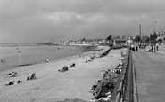
This is a very popular view of the town, showing the three bays separated by rock outcrops. The pier was built on one of these outcrops in 1865, only to be damaged in a storm the following year.

It was the early use of bathing machines that made Weymouth such a popular resort for sea bathing.The larger machines ran down into the water on rails and consisted of a number of cubicles.

This view looking towards town captures well the flavour of interwar development along the Tring Road itself.

Lancaster's beautiful canal, with its magnificent sea views of Morecambe Bay, was originally the vision of the factory owners of the locality, who were eager to connect their mills with the national canal

The Church of St Andrew is special. In the centre is the original church of about 960, which consisted of a nave and chancel with choir stalls and an 1880 organ. The church extends in all directions.

Of the fine climate of Colwyn Bay there can be no doubt whatsoever. Flowers bloom here until well on towards Christmas, and are out again in some profusion in February.

North Street was mainly residential in the early 20th century, with some splendid houses, including thatched cottages. They became derelict in the 1920s and were demolished in 1933.

Gregory Gregory, a bachelor, was probably responsible for as much of the design as his architects, Anthony Salvin and later William Burn, as it rose slowly throughout the 1830s and 1840s.

This former slate-mining village lies below Cadair Idris, cupped in the Dysynni valley between Tal-y-Llyn and Tywyn.
The town of Oban is only a little more than 200 years old. It owes its origins to when a fishing station was established here by the government Fishery Board in 1786.

Little has changed here: the cannon has gone, and the buildings between the gatehouses now have dormers.

The basic fabric of the church can be no later than the end of the Early English period, around 1300. The elegant five-bay north and south arcades are witness to this date.

This view looks southwards across Lyme Bay from the main path through Langmoor Gardens, which were given to the town by James Moly of Langmoor Manor, Charmouth.

A steamer, with a party of sightseers on board, has just left the quay heading down river. The women cluster at the stern under parasols. A little further along on the left is Cleopatra’s Needle.
A steamer, with a party of sightseers on board, has just left the quay heading down river. The women cluster at the stern under parasols.

This is a detail of the chalet zone which sprang up behind the 1897-built Esplanade (right), between the waterworks and the Salt House on Pitfield Marsh (left).
Places (0)
Photos (134)
Memories (540)
Books (3)
Maps (896)

