Places
26 places found.
Those places high-lighted have photos. All locations may have maps, books and memories.
- Cemmaes Road, Powys
- Six Road Ends, County Down
- Road Weedon, Northamptonshire
- Severn Road Bridge, Gloucestershire
- Roade, Northamptonshire
- Berkeley Road, Gloucestershire
- Harling Road, Norfolk
- Road Green, Devon
- Builth Road, Powys
- Cross Roads, Yorkshire
- Steele Road, Borders
- Cross Roads, Devon
- Four Roads, Dyfed
- Road Green, Norfolk
- Biggar Road, Strathclyde
- Clarbeston Road, Dyfed
- Five Roads, Dyfed
- Eccles Road, Norfolk
- Grampound Road, Cornwall
- Morchard Road, Devon
- Wood Road, Greater Manchester
- Four Roads, Isle of Man
- St Columb Road, Cornwall
- Clipiau, Gwynedd (near Cemmaes Road)
- New Road Side, Yorkshire (near Silsden)
- New Road Side, Yorkshire (near Cleckheaton)
Photos
14,329 photos found. Showing results 3,201 to 3,220.


Maps
476 maps found.
Books
5 books found. Showing results 3,841 to 5.
Memories
11,058 memories found. Showing results 1,601 to 1,610.
About 1940
Around about 1940 I was evacuated to Huntingdon, my age was about 5 or 6 years. I remember I stayed with a little old lady and I think she had one son who came home on leave while I was there. Her house was attached to a church or ...Read more
A memory of Huntingdon by
Stiperstones Poem
THE STIPERSTONES T’was long ago the Ludlow people vexed the Devil very sore He vowed to stone their homes and steeples until they were no more On Cranberries Hill he then collected his apron full of rocks and stones With ...Read more
A memory of Stiperstones by
Durell Road, Martins Corner
What a place! If you're not born here, run for the hills! But I love it, I still see faces of long ago that do too, or why didn't we move away a long time ago!! My mum and dad were the best, I never got hit by them but ...Read more
A memory of Barking in 1970 by
Our Street
Our Street was named Aston Street at the back of the Kings Arms pub in Rochdale Road. It was an amazing little street with a tripe shop and pies at the top of the street, a garage next door which housed Johnny Raffo's Ice Cream Vans, ...Read more
A memory of Collyhurst in 1949 by
Lt Spencer Baker Died At Passchendaele 1917
Spencer Baker was my grandfather's cousin. He grew up at Forest Farm, Chelwood Gate, son of Spencer snr and Susan Baker (née Lindfield). Spencer was a building contractor and at the age of 29, in ...Read more
A memory of Chelwood Gate by
Northolt Memories
I was born at Perivale hospital in 1964 and grew up in Carr Road. I am one of the Tweedy family that Toni mentioned .....Hi Toni (keep in touch). I lived there with my parents Dora and Andrew, both now 81 years young.... and ...Read more
A memory of Northolt by
The Bus.
Can anyone remember the blue bus that used to come up New Road on to the main parade of the shops, down Bedfont Lane and into Feltham over the railway a few times a day? The driver was Keith, he wore glasses, I would like to know what his surname was.
A memory of Bedfont by
Personal Memories
My father was born in Alexandra Street in 1921 in the house owned by my great aunt Miss Ida Thomas who was a school mistress, my grandparents lived in Letchworth Road and my father's sister, Kathleen Jones, who was also a ...Read more
A memory of Ebbw Vale in 1958 by
Born In Lower Bedfords Road
I was born in Lower Bedfords Road and as a young child I can remember cattle coming down the road to go in one of the fields in Bedfords Park. My mum used to shoo them out of the garden with a tea towel. I ...Read more
A memory of Havering-atte-Bower in 1960 by
Cherished Memories
I can remember taking part in the Easter Parades, hundreds of children would walk or ride on the beautifully decorated floats, we would walks round Tupton on Ankerbold Road, Station Road on towards the Royal Oak up Ashover ...Read more
A memory of Old Tupton by
Your search returned a large number of results. Please try to refine your search further.
Captions
5,036 captions found. Showing results 3,841 to 3,864.

The cliff path, landscaped between stone walls, became Isle of Wight Road.

Seen in the centre of the photograph, but also marginalized, are the houses alongside the old Hereford Road and the steam of the Hereford to Abergavenny train.

This picture looks towards the castellated Victorian pile of Kingsgate Castle, with the white houses of Kingsgate Bay Road on the right.The largest of these is Holland House, built for Lord Holland

The off-licence on the corner of Lackford Road and Station Parade no longer sells Watney`s ales, and currently remains empty with a chartered architect`s name by the door.

Climbing up from Dulverton the road crosses typical sheep-grazed Exmoor moorland, bright with yellow gorse flowers and heather, before descending into Winsford in the upper Exe valley.

Ashtead stands beside the Rye, a tributary of the Mole, and judging by the signs for the tea gardens and a 'cyclist`s rest', passing trade on the Leatherhead to Epsom road was much sought-after

The road through the village follows the route of the Guildford to Arundel turnpike, completed in 1809. Medieval glass was also made near here in Sidney Wood.

Gawcott, a mile and a half south-west of Buckingham, lies at the head of a stream (flowing north into the River Ouse) whose course runs along the right-hand side of this road.

This view looks northwards along Middle Street (otherwise known as Chapel Street) in the centre of the village towards a 17th- century thatched cottage on the corner with Grove Road (centre

This was agreed, and so Castle Bridge was built, the castle grounds were extended and the old road below the castle walls was closed.

replace the original one, which was demolished along with several other buildings in order to create space for the erection of St George's Congregational church, which stands a little further along Neston Road

Many Fylde inns were named 'Horns', presumably harking back to the days when herds of deer roamed here. Some inns of that name sported splendid antlers as inn signs, as at Goosnargh.

The dusty roads were regularly sprayed with water in the summer to protect walking pedestrians. Sometime after this picture was taken, the property was condemned and partly rebuilt using local flint.

In this village, just off the Knaresborough to York road, stands the ancient church of St John the Baptist, a thousand years old.

This is the Colsterworth Road, and the lane to the left is Lord's Lane - but which Lord it does not state.

For a very built-up area, Dudley has always had a number of green, open spaces, including the Civic Gardens, situated between Priory Road and The Broadway, opposite the Council House.

Bossington, at the foot of Bossington Hill and on a loop road from the A39, merges with the hamlet of Lynch; it is a pretty village, with whitewashed sandstone rubble houses.

The buildings are shaped here to follow the curve of the road. The first shop on the right is now a florist. Morgans, 'Complete House Furnishers', has become the Alamo restaurant and bar.

Lee Lane (left) at its junction with Dorchester Road, has a stone commemorating the escape of King Charles II after being defeated at the Battle of Worcester.

The road sign points down South Street which is almost invisible between the public building and the shops. Colmer`s Hill (right of centre) forms the distant skyline.

Broadly speaking, the valley along Broad Street and Berkhamstead Road was for artisans and the working classes, the areas to east and west were middle class.

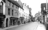
The lines of parked vehicles on both sides of the road tend to detract from the architectural riches of the fine Tudor, Georgian and Victorian buildings that adorn this spacious street; they are evidence

The pretty village of Kemsing, on the Pilgrims' Way, boasts St Edith's Well, which is just by the walled war memorial at this road junction.

It made the corner for Somerset Avenue, a name which with others like Tennyson Avenue, Southwell Road and Holborn Street, might have brought a touch of the supreme Brighton.
Places (26)
Photos (14329)
Memories (11058)
Books (5)
Maps (476)

