Places
5 places found.
Those places high-lighted have photos. All locations may have maps, books and memories.
Photos
9,649 photos found. Showing results 821 to 840.


Maps
18 maps found.
Books
13 books found. Showing results 985 to 13.
Memories
4,612 memories found. Showing results 411 to 420.
Thanks For The Memories
My goodness this brings back memories! I grew up in Irby and we lived in Oaklea Road from the late 40’s to the late 60’s – I’m now a true blue Aussie having lived in Queensland since the mid 70’s but about to revisit Irby in ...Read more
A memory of Irby by
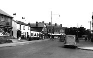
Boat Road, Barnton What Happened To The Houses?
Hello. I've just been looking at a picture of the canal and houses at Boat Road, Barnton. The photo was taken in the very early '50's and I was thinking what a lovely-looking 'canal village' it looked ...Read more
A memory of Barnton in 1953 by
Childhood Days
I was evacuated to Reepham from London, when the war was going on. I lived in the high street with a Mrs Tonn, and a Mr & Mrs Mason on their farm. The days of freshly made butter and milk! Farm animals as pets! I ...Read more
A memory of Reepham in 1940 by
Cook Family
As a child I visited my grandmother at Ivy Cottage where my mother was born in 1910. The Cook family and the Faircloths were the backbone of the village. Granny Cook lived in the house next door to Ivy Cottage. It was an ...Read more
A memory of Crockleford Heath in 1953 by
The Taplin Family
Hello, my Great-Grandmother worked in Blockley silk mill. Her name was Emma Taplin, then she went on to marry a West. Her family lived in Paxford and her father worked on the Blockley railway. I only live down the road from ...Read more
A memory of Blockley in 1880 by
Memories Of Caldecott
I was born in Caldecotte on 26,09,58, a great little village. I came from a family of 5 children, times were hard moneywise, but we always got by. We used to grow all our veg and kept chickens and ducks for meat. Dad was ...Read more
A memory of Caldecott in 1967 by
Stubbington 1956 1968
Thank you Lorraine for the many memories you brought back. I lived in Queens Crescent from when I was born in 1956 until I moved to Australia in 1968. I also remember the bakery on the corner of the lane by the school ...Read more
A memory of Stubbington in 1962 by
Honeymoon
Alas my wife passed away in 2005 but my memories are still very vivid re St Columb Minor, maybe someone reading this will know where I am talking about, our honeymoon was spent in a cottage next to the village pub, Mr & Mrs ...Read more
A memory of St Columb Minor in 1963 by
My Youth
I lived in Tamar Drive and went to the local school, my senior school was Lennards Comprehensive. My best mates were Jenny Cutler, Shirley Jassec, Pat Madder. We spent alot of time roaming the streets, I remember the fair coming to town ...Read more
A memory of Aveley in 1960 by
My Memory Is Of Foodieash
I lived in Foodieash from the age of 3 to 17 and remember it as a peaceful little village, there was no electric, the loo was down the back garden, but they were happy days. I remember going to Foodie farm every ...Read more
A memory of Blebocraigs in 1940 by
Captions
5,016 captions found. Showing results 985 to 1,008.

Just outside the village of Weston Rhyn there is an unusual folly - a romanticised Stonehenge. It was erected in the 19th century by Thomas Barnes.

Taken from the eastern end of the village, above Burbitt Lane. This view looks north-eastwards to St Martin's Parish Church (right), and the distinctive 599-feet profile of Shipton Hill (centre).

This view looks south-east across the Mawddach estuary saltings towards the village, which lies on the south shore. The great bulk of Cadair Idris rises behind it.

Sixty years earlier the village had five inns and taverns, all of which took in paying guests; the Crown & Anchor, the Jolly Sailor, the Red Lion, The Ship, and the White Swan.

Finely situated on the brow of a hill to the north-east of the village, the hydro offered guests the usual water treatments and dietary regimes.

The Cliffe Hotel was a very popular hotel in Victorian days.

The village's name comes not from some gruesome event in its past, but probably from the Old English word 'sclotre', meaning a muddy place.

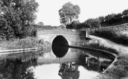
To the east of the village, the canalised river was heavily used for carrying stone, and waggon tipplers for loading up the boats can still be seen.

Lying about ten miles east of Hawes, Aysgarth is famous for a series of waterfalls on the River Ure, the upper of which can still be viewed from a 16th-century single-arch bridge.

Here we see the heart of the famous Cornish fishing village at its quaintest, and most deserted.

Nearby is the former village lock-up, built in 1830, and moved to its present position from its original site in the village street.
Lying about ten miles east of Hawes, Aysgarth is famous for a series of waterfalls on the River Ure, the upper of which can still be viewed from a 16th-century single arched bridge.

This view from the banks of the River Great Ouse looks towards the village, with the tower mill in the distance.

Instow is on the Torridge, opposite Appledore. Apart from a reinforced sea wall, this view of Marine Parade is little changed today. Here, visitors await the ferry for Appledore.

The excellent quality of the buildings at Marnhull shows that this part of the Blackmore Vale was wealthy from agriculture.

Fernhurst lies due north of Midhurst in rolling, wooded border country near the Surrey town of Haslemere.

This view shows Curbar and Baslow Edges in the background, with the houses of the village filling the dale in the foreground.

We are looking towards Colne with the road up to the Heath on the left. The thatched cottage on the left was until recently home to the village carpenter and funeral director.

This scene, with Lieutenant Colonel Tebbutt's 19th-century barograph under the shelter in front of the village shop has hardly changed.

Beyond the houses on the right- hand side of the road is the village recreation ground complete with its new Millennium village hall, a welcome amenity for the residents of Scaynes Hill.

One of the few thatched buildings in the area, the Duke's Head is no longer a public house.

The about-turn view of the last picture, this shows the unmistakable path beaten across The Green to the Queen's Head.

This charming Devon fishing village lies alongside the broad waters of the Torridge River, which swings left just beyond the point to join the Taw and the open sea.

7 miles from Clitheroe on the banks of the River Hodder amidst moorland, Slaidburn is a popular village with walkers and cyclists. The view from the bank shows the 15th-century church of St Andrew.
Places (5)
Photos (9649)
Memories (4612)
Books (13)
Maps (18)

